7. Masterplan
Wider linkages
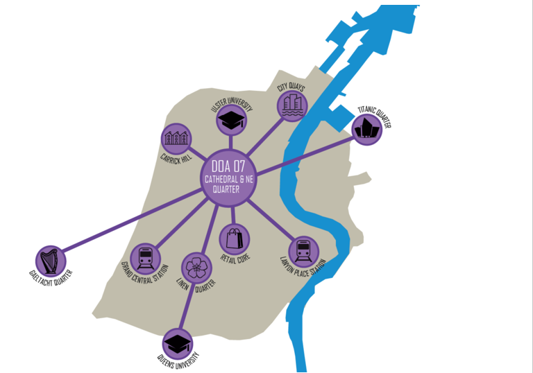
DOA_07 Cathedral and North East Quarter benefits from its central location within the city centre being located just north of the city centre retail core and Linen Quarter and adjacent to Ulster University’s city campus. To the north west, the area is a short walk from the established residential neighbourhood of Carrick Hill and Shankill Road beyond, while a short walk to the north east lies City Quays an office-led regeneration project located along Belfast’s iconic waterfront.
Further afield, the DOA is within walking distance of the recently constructed Belfast Transport Hub (Grand Central Station) in addition to Lanyon Place Station. Frequent glider services ensure that the DOA is a short trip to Queen’s University along the edge of the city centre to the south and Titanic Quarter to the east. Future pedestrian and cycle bridge connections across the River Lagan will improve connectivity to the expanding Titanic Quarter to the east.
Location of DOA_07 Cathedral and North East Quarter
This diagram shows the location of Cathedral and North East Quarter in relation to the residential community of Carrick Hill, Ulster University, City Quays and Titanic Quarter, as well as the Retail Core, Linen Quarter, Grand Central Station, Lanyon Place Station and further afield to Queen's University and the Gaeltacht Quarter.
Heritage and vacancy
This DOA includes a wide range of listed and non-listed heritage assets. While the jewel in the crown is undoubtedly St Anne’s Cathedral along Donegall Street, other key examples include the Assembly Rooms and Merchant Hotel on Waring Street alongside a collection of buildings on Rosemary Street including the Masonic Hall, First Presbyterian Church and Central Hall. While the Art Deco style North Street Arcade is also listed, the 2004 fire and subsequent deterioration of the building has unfortunately left the two entrances along North Street and Donegall Street as the only salvageable elements.
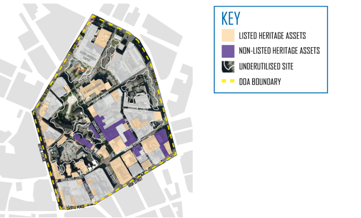
This historic part of the city centre also contains several sizeable, underutilised sites scattered across the study area. These include a number of surface car parks and when considered alongside the two poorly designed public spaces (Writers' Square and Buoys Park) and buildings which are either in a poor state of repair or of poor architectural quality, the extent of land that present future development opportunities becomes immediately apparent.
While the potential exists in developing those larger underutilised sites, opportunities are also presented via the re-purposing of those non-listed heritage assets which are for the most part located in the south east quadrant of the DOA. While active uses would be promoted at ground floor level, these non-listed heritage assets could be re-purposed as much sought after residential accommodation at upper floor levels.
DOA_07 Cathedral and North East Quarter underutilised sites
This plan illustrates the spread of underutilised sites (largely surface car parks) across the DOA area including lands west of North Street, lands between North Street and Donegall Street including Writers' Square) and lands to the north and north east at Buoys Park, along the Dunbar Link and along the eastern edge of Academy Street. The plan shows listed assets in cream blocks and non-listed assets in purple blocks.
Strengthened connections
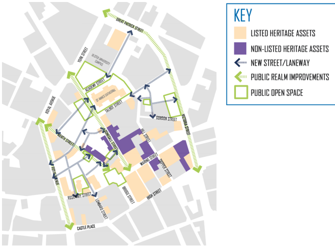
One of the primary placemaking principles for DOA_07, is the promotion of a heritage-led approach to redevelopment that seeks to restore and revitalise the plentiful historic building stock that exists across the area. The aim is to achieve this in a way that not only showcases the rich diversity of heritage assets, but in a manner that also reconnects the fragmented urban fabric to achieve a permeable network of new streets and laneways. These newly formed connections will complement and extend existing streets and laneways and echo the historic planform and grain that once existed.
Alongside the reintroduction of these historic connections is the realisation of a series of legible and interlinked public spaces. These range from the more civic and formal spaces adjacent to and opposite St Anne's Cathedral (Donegall Street), Ulster University (York Street), Assembly Rooms (Donegall Street, North Street, Bridge Street) and First Presbyterian Church (Rosemary Street), to more intimate spaces found centrally within urban blocks and along laneways.
A key consideration in deciding the alignment of new streets and spaces is the opportunity they present to enhance the setting of listed assets. For example, new connections off North Street provide framed axial views of St Anne's Cathedral with the newly formed and animated Writers' Square providing a degree of relief opposite.
DOA_01 Sailortown, Greater Clarendon and City Quarter proposed permeable network of streets and spaces
This plan illustrates how a permeable network of streets and spaces could strengthen connections across the area.
Reknit and activate
The next key move is to establish a series of new urban blocks that align the network of new streets, laneways and public spaces and reknit the urban fabric. Where these are standalone, they will take the form of perimeter blocks with a degree of private space provided centrally. In other locations these new blocks will, together with existing adjacent buildings, form completed perimeter blocks.
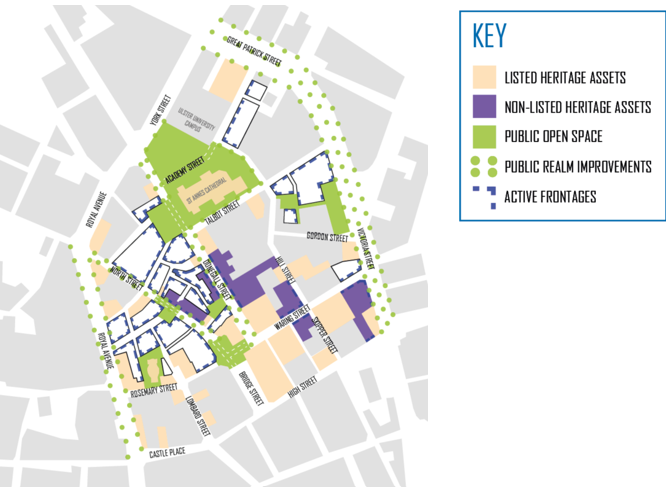
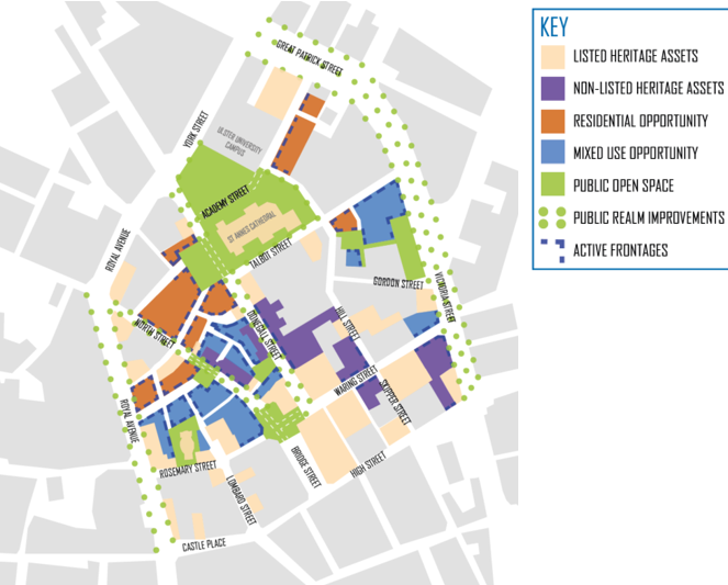
Active uses at ground floor locations of particular blocks (dotted blue lines on plan) will not only help to provide additional animation at street level but will help to forge a hierarchy of streets and laneways that will assist in creating a more legible urban environment while enhancing the evening and night-time economy. Where blocks front directly onto public spaces or primary streets, every effort should be made to ensure active uses are promoted at ground floor level.
Further consideration has been given to the configuration of the linked public spaces. The setting of St Anne's Cathedral has been enhanced by way of a holistic approach being applied to the series of open spaces surrounding, adjacent to and opposite the listed asset. This approach will allow for a degree of traffic calming along both Donegall Street and Academy Street, while the new Ulster University campus will help to activate and animate its northern edge.
DOA_07 Cathedral and North East Quarter proposed development blocks
This plan illustrates how new development blocks could be formed within the network of streets and spaces. Active edges of blocks have been identified alongside those streets which would benefit from public realm improvements
Vision and masterplan
This area borders the City Core character area. This is reflected in the general spread of uses across the DOA with mixed use opportunities proposed along its southern and eastern extents. These are complemented by a range of residential opportunity sites proposed more centrally and to the north concentrating around a newly formed Writers Square and Cathedral Gardens, both of which help to supplement amenity space requirements.
The Innovation District character area of the City Centre Concept Diagram places emphasis on the promotion of lively, mixed-use innovation uses. As the DOA_07 Vision illustrates, a Creative and Innovation corridor links the Assembly Rooms and civic space to the Ulster University campus to the north. This corridor comprises a range of smaller plots within the North Street, Donegall Street ‘wedge’, including a re-imagined North Street Arcade, and will cater for a diverse range of creative uses along an extended network of laneways.
DOA_07 Cathedral and North East Quarter alloted uses to development blocks
This plan allots uses to development blocks with mixed use sites largely across the southern half of the area (closer to the retail core) with residential sites closer to the north around the public open spaces associated with Buoys Park, Writers' Square and the enhanced setting of St Anne's Cathedral.
Key initiatives
The range of proposals within the Concept Plan respond to a unique opportunity to regenerate this historic part of Belfast with a series of residential and vibrant mixed use development proposals, alongside a network of high-quality public spaces and public realm initiatives. Located centrally within the DOA, the lower section of North Street contains an eclectic mix of building styles, heights and traditional materials. Buildings of note include the listed Assembly Rooms (former Northern Bank) at the junction of North Street and Donegall Street and the neighbouring listed Braddell building.
The Concept Plan seeks to realise a vision through the promotion of a heritage-led approach comprising a range of residential and mixed-use opportunities focussed around a central creative and innovation corridor. In line with this vision, this Concept Plan promotes a number of permeable street and laneway connections alongside a series of new urban blocks, as a nod to the dense urban form and network of street and laneway connections that were historically synonymous with this area.
The most notable connection is a re-imagined North Street arcade, a route which rediscovers a once thriving Art Deco shopping arcade that connected North Street to Donegall Street and was subject to an arson attack in 2004. A new laneway is also proposed along the southern boundary of the Braddell Building, to create an intimate pedestrian route from North Street to Donegall Street. Finally, a series of new permeable laneways connecting Talbot Street, Hill Street and Gordon Street with Great Patrick Street, would allow for new development opportunities around an intimate central space.
Proposals seek to deliver active frontages at ground floor level across the area through the provision of uses such as retail, restaurant and café at strategic locations. The aim of these uses is to provide activity, animation and increased footfall along key routes and along the edges of public open spaces, while improving passive surveillance and perceptions of safety. A mix of predominantly residential and office uses are proposed on upper floors alongside a range of community floorspace.
A key aspiration is the formulation of a Landscape and Public Realm Strategy based on a hierarchy of streets and public spaces, comprising civic spaces and squares, primary streets, secondary streets and laneways and entries. A series of shared public spaces are included within the Concept Plan including new spaces at Bridge Street and Writers' Square, with the latter reorganised and defined by new active frontages to improve activity, extend usage and enhance the setting of St Anne’s Cathedral. Public improvement works are also advocated along North Street, Donegall Street and Talbot Street.
New and improved connections are proposed linking North Street to Writers' Square, Upper Lombard Street and Donegall Street as well as connecting Rosemary Street to Upper Lombard Street. A key initiative within the Concept Plan is the transformation of Cathedral Gardens into a world class public space for people to gather, relax and play. This transformed space adjacent to St Anne’s Cathedral would include an urban forest, multi-use events space, public art and a range of play features for children.

