7. Masterplan
Wider linkages
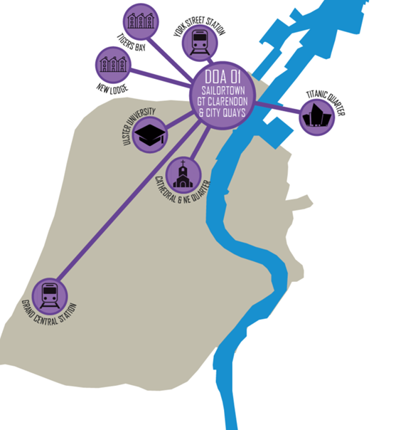
DOA_01 Sailortown, Greater Clarendon and City Quays area is located along the northern edge of the city centre and is defined by the River Lagan along its eastern edge. The area's strategic gateway location means it is in close proximity to Ulster University’s city campus, in addition to the expanding waterfront development opportunities within City Quays and Donegall Quay, in close proximity with the pedestrian and cycle connection across the River Lagan and weir to East Belfast and Titanic Quarter.
The area benefits from being on the doorstep of the recently refurbished York Street Railway Station and close to a number of established north Belfast neighbourhoods including New Lodge and Tiger's Bay. Due south, the area is within walking distance of the thriving Cathedral and North east Quarter and the many services, food and beverage options this growing area presents.
Graphic illustrating location of DOA_01 Sailortown, Greater Clarendon and City Quays
This plan illustrates location of Sailortown, Greater Clarendon and City Quays in relation to York Street Station, Titanic Quarter, Ulster University, Cathedral Quarter, Grand Central Station and the residential communities of New Lodge and Tiger's Bay.
Heritage and vacancy
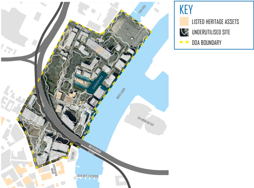
This DOA includes a number of listed assets (coloured cream) which are located centrally along either side of Corporation Square as well as adjacent to Clarendon Dock. The listed assets along Corporation Square includes the Belfast Harbour Office, the Sinclair Seaman’s Presbyterian Church to the west and 5-7 Corporation Square diagonally opposite. Moving further north, listed assets include the Pump House at Clarendon Dock and St Joseph’s Church on Princes Dock Street.
In a similar vein to other DOAs, this area along the northern edge of the city centre contains several large, underutilised sites which vary in size. At the lower end of the DOA these include a number of surface car parks immediately south and north of the M3 flyover/Railway along Corporation Street, Tomb Street and Corporation Square. More centrally large swathes of surface car parks and vacant sites flank either side of Corporation Street while the largest of the surface car parks occupies the NE corner of the area adjacent to York Dock.
This wide range of underutilised sites presents the opportunity to repair the urban fabric with new street facing buildings that include contemporary city centre accommodation along a network of new north to south and east to west connections while enhancing the area's heritage assets.
DOA_01 Sailortown, Greater Clarendon and City Quays under utilised sites
This plan illustrates the spread of under utilised sites (largely surface car parks) across the DOA area including lands south of the M3 flyover, lands either side of Corporation Street and lands to the north east along the river.
Rediscover the grid
This area once comprised a comprehensive series of tight-knit streets which for the most part were laid out in a grid-iron pattern. On a north-south axis, primary routes such as York Street, Corporation Street and North Queen Street connected the railway terminus and communities in the north of the city with the city centre.
On an east-west basis, the myriad of parallel streets which included the primary routes of Great Patrick Street, Great George’s Street, Henry Street and Earl Street, provided direct connections between Sailortown (Belfast’s first waterfront village) and the industries associated with the River Lagan. The area of Sailortown quickly became known as an area where dockers and immigrant families settled while seeking work in the thriving shipyards and docks.
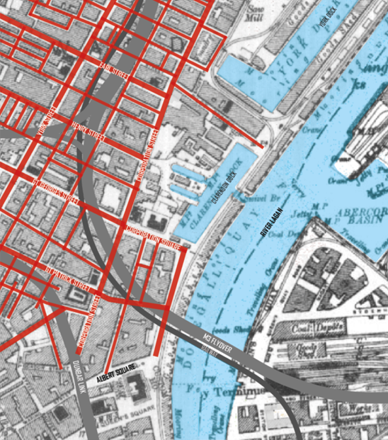
In the late 1960s, urban redevelopment projects which included the Belfast Urban Motorway (highlighted M3 Flyover and Dunbar Link on adjacent plan), was a contributing factor that led to the demolition of much of Sailortown and the displacement of its residents. The opportunity now exists to rediscover this lost grid-iron street pattern and use it as a basis to inform a legible network of new streets for new development opportunities.
Historic plan of Sailortown
The plan shows the tight network of streets across Sailortown. The M3 flyover and railway line are overlaid on top to illustrate the devastating effect these pieces of infrastructure had on the urban form.
Extend the grid
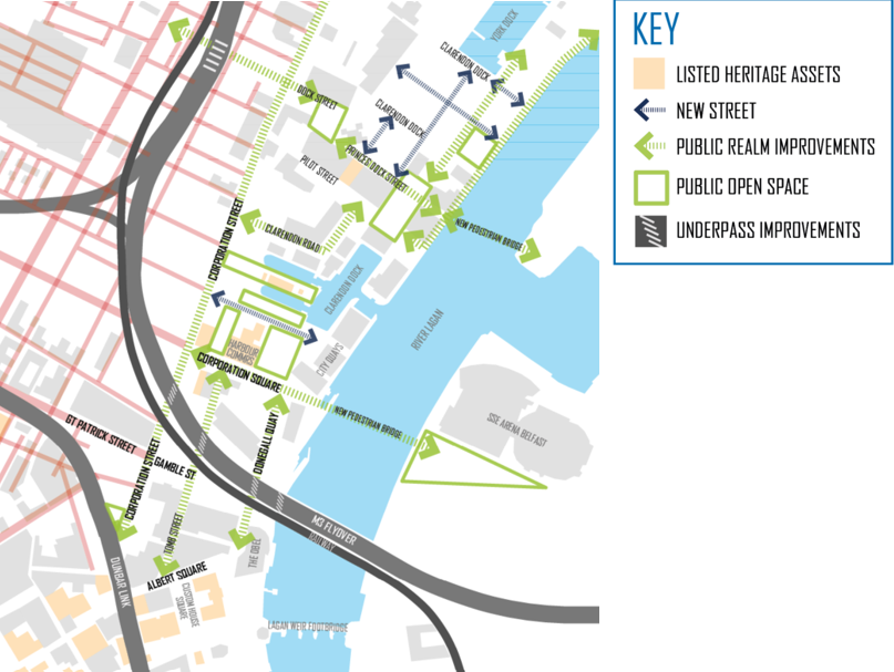
Extending the historic grid across the study area allows those lost E-W connections to be rediscovered to enable communities to both visually and physically reconnect to the river’s edge. These connections can then be extended further east through the realisation of a pedestrian and cycle bridge linking the area across the River Lagan to Titanic Quarter.
Peppered along this permeable series of new streets, a range of green spaces are envisaged. Notable green areas include a series of interconnected space towards the northern end of the DOA along Dock Street, Princes Dock Street and the waterfront. However, the jewel in the crown is undoubtedly the large central public space which encapsulates the listed Pump House and wider setting of Clarendon Dock, which then connects seamlessly to the recently completed City Quays Gardens adjacent to the listed Harbour Office.
DOA_01 Sailortown, Greater Clarendon and City Quays proposed street network
This plan illustrates how a new network of streets and spaces could be informed by the historic street pattern.
Form new edges
This new network of streets and spaces is then defined by a series of urban blocks with an emphasis placed on Corporation Street as the main north to south spine route through the area. New urban blocks along either side of Corporation Street provide this key route with a sense of enclosure that has long been eroded and along with it increased animation and activity. While consideration will need to be given to the alignment of any future York Street Interchange proposal, the masterplan proposes that adequate depth is retained along the western side of Corporation Street to enable a new active, development edge to be formed.
Blocks have been sensitively placed along Corporation Street to frame but not encroach on the setting of the listed Pump House and wider Clarendon Dock. Separation distances between blocks provide a degree of shelter and backdrop to central Clarendon Dock green space, with direct axial views to the listed Pump House maintained off Corporation Street.
The north west corner of the site leans itself to a traditional grid iron street layout that echoes the historic planform that once existed in Sailortown. This series of perimeter blocks maximises the amount of activity that can be achieved along new streets with blocks in this location centring around a new waterfront green.
DOA_01 Sailortown, Greater Clarendon and City Quays proposed new development blocks
The plan illustrates how new development blocks could be formed within the network of streets and spaces. Active edges of blocks have been identified alongside those streets which would benefit from public realm improvements.
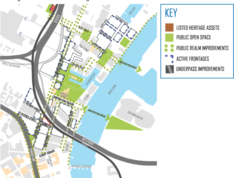
Vision and masterplan
This area falls within the Waterfront District character area. This is reflected in the general layout and spread of uses across the DOA where opportunities have been taken to extend the city centre east to better activate the River Lagan and animate the riverfront.
Mixed use sites are for the most part located towards the southern end of the DOA, however the key thrust of this masterplan is the injection of much needed city centre residential accommodation along both existing and new streets. Subject to detailed assessment, the potential exists to achieve more sustainable medium/high densities at particular locations, where a degree of height could be considered.
Two pedestrian bridges are suggested in line with the city centre concept to forge stronger connections between communities, businesses and tourist destinations either side of the river. Public realm improvements are also proposed along those streets that connect to the bridges and in the case of the northern bridge, extend to ease movement to York Street train station.
DOA_01 Sailortown, Greater Clarendon and City Quays alloted uses to development blocks
The plan allots uses to development blocks. Mixed use sites are largely south of the M3 flyover and residential sites north of the flyover. A key public space is proposed centrally to enhance the setting of the listed pump house and dock with taller opportunities identified at particular development blocks.
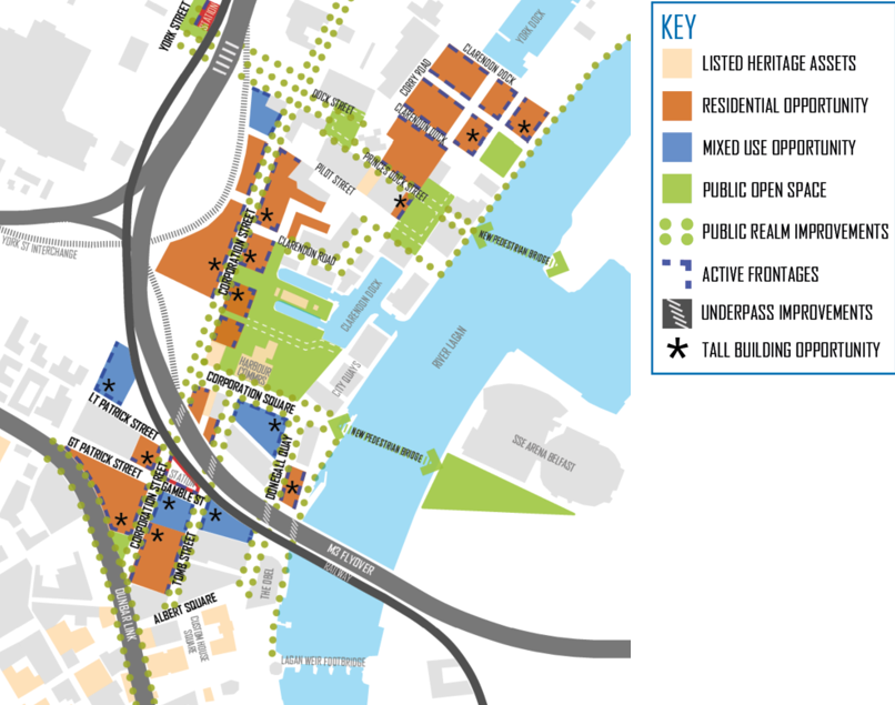
Key initiatives
The proposed scale, height and massing of any new build should be mindful of surrounding context, particularly towards the north of the area. Particular attention should be paid to the impact of new development on the setting of listed assets, including those around Corporation Square where opportunities can be taken to reference the area’s industrial past in new buildings through the articulation of façades and choice of material palettes.
New development fronting Dunbar Link, Corporation Street and Tomb Street should seek to contribute to boulevard treatment along these routes. Active frontages should be provided alongside high-quality public realm and landscape works with continuous pedestrian footpaths and cycle lanes. As an integral element of these works, temporary and permanent solutions should be explored to repurpose lands beneath the M3 flyover to ensure a more animated and safer environment at these underpass locations.
The masterplan allots a degree of hierarchy to other key routes where bespoke public realm improvements are advocated. Corporation Square plays an important factor in this regard, not only in the role it plays enhancing a number of the areas listed assets, but also its adjacency to a potential pedestrian bridge linking City Quays to Titanic Quarter (SSE Arena). In a similar vein, a second key route highlighted for public realm improvements is Princes Dock Street with its potential to link east to a future pedestrian bridge linking Sailortown to Titanic Quarter and westwards to the recently upgraded York Street Train Station. A final key connection is Clarendon Road which would link the new bridge south to a large central open area associated with Clarendon Dock.
Opportunities for taller buildings at strategic locations including sites either side of the M3 flyover (Dunbar Link, Tomb Street and Corporation Street), along Corporation Street to form new animated edges to this spine route as well as along the waterfront. New active edges should be formed either side of Corporation Street, with accommodation made for any future York Street Interchange alignment to the west.
Higher densities are encouraged on sites south of the M3 flyover, where the potential exists for taller buildings (subject to detailed assessment). Medium density housing opportunities should be considered for sites along Corporation Street north of the M3 flyover. Where residential uses are proposed at GF level, steps should be taken to protect amenity levels including defensive planting or recessed frontages.
Other strategic moves to improve wider connectivity is the realisation of a future rail halt at Gamble Street and the opportunity to secure a new footbridge across the River Lagan connecting Sailortown with Titanic Quarter. In relation to this aspect, two possible routes have been shown on the Concept Plan, the first to the north a crossing at Princes Dock Street with the second linking into the heart of City Quays and Corporation Square.
The York Street interchange remains a key strategic project affecting the western portion of this area. The Concept Plan advocates that emphasis be placed on raising the overall quality of the urban environment with a view to securing enhanced permeability to reduce the severance and physical barriers to pedestrian and cycle movement that the legacy of road infrastructure has had on the area.
