Published: December 2018 - January 2019
The Inner North West Framework has been prepared on behalf of Belfast City Council to provide proposals for the area as a part of the wider strategic development of the city. The masterplan seeks to provide a framework to help shape emerging opportunities and ensure a more comprehensive approach to development of both public and private sector owned land.
Feilden Clegg Bradley Studios (FCBS) was appointed in December 2016 as Masterplanner and Urban Designer to lead a team of Consultants (JUNO – planning; Systra – transport; The Paul Hogarth Company - landscape) with an in-depth knowledge of Belfast and regeneration issues and challenges. The design team worked in collaboration with the Belfast City Council to produce a masterplan for the Inner North West (INW) that seeks to guide future development in this area and help deliver the aims of the Belfast Agenda and City Centre Regeneration and Investment Strategy.
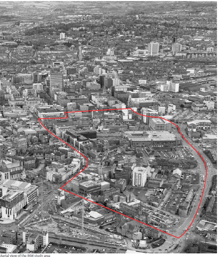
Aerial view of the Inner North West study area
Table of Contents
Introduction
1. The Inner North West in Context
1.1 Surrounding Context
1.2 The Area
1.3 Historic Context
1.4 Emerging Context
1.5 Planning Context
1.6 Socio-economic Context
1.7 Environmental Context
2. The Inner North West Analysis
2.1 Heritage - Existing Assets
2.2 Underdeveloped Sites and Public Ownership
2.3 Existing Challenges
2.4 Millfield and Carrick Hill Road
3.1 City Centre Mixed Neighbourhood
3.2 Masterplan Objectives
4. The INW Urban Design Principles
4.1 Create a Network of Open Spaces
4.2 Improve North South Connections
4.3 Improve East West Connections
4.4 Heritage to Inform the Masterplan
4.5 Identify the Key Opportunity Sites
4.6 Mixed Uses to Support City Centre Living
4.7 Create Density for Population Growth
4.8 Create a Strong Street Hierarchy and Active Frontages
4.9 Provide Appropriate Public Parking
4.10 Support Public Transport
5.1 Street Typologies
5.2 Building Typologies
6. Character Areas and Streets
6.1 Queen Street
6.2 Castle Street and King Street
6.3 Bank Square
6.4 Smithfield Market
6.5 CastleCourt
6.6 North Street
6.7 North Street - Public Space
6.8 Union Street - Public Space
6.9 Donegall Street
6.10 Carrick Hill / Millfield
7.1 Delivery
8.1 Case Study: Distillery District, Toronto
8.2 Case Study: Temple Bar, Dublin
8.3 Case Study: Northern Quarter, Manchester
Introduction
The City Centre Regeneration and Investment Strategy (2015) and The Belfast Agenda (2017) collectively set out an ambitious vision for the future development of the city centre. This vision provides a strategic context for the city’s regeneration activity for the next 10-15 years and identifies the range of opportunities presented by the city’s largescale developments, such as Ulster University, the Transport Hub at Weavers Cross, Royal Exchange and the ongoing development of the Titanic Quarter. These projects and others will catalyse growth and employment across Belfast in the years ahead.
The City Centre Regeneration and Investment Strategy (CCRIS) identifies five Special Action Areas (SAA) where there is a pressing need for change and where detailed development frameworks and/ or masterplans should be developed to facilitate growth. This document examines the ‘Inner West’ SAA along with parts of the Inner North. The area encompasses part of Belfast’s retail core and sits adjacent to Ulster University, the Cathedral Quarter, and residential neighbourhoods to the north and west.
Belfast City Council has established a new vision for the city in the Belfast Agenda document which promotes four priorities: ‘Growing the Economy’, ‘Living Here’, ‘City Development’ and, ‘Working and Learning’. The INW has all the relevant attributes to contribute to these priorities and the city’s vision and wider ambitions.
The Inner North West is currently underdeveloped and in need of significant investment to address long-term dereliction in the area. This document seeks to for provide coherent development across the many vacant and underutilised sites. At the same time, development of the INW needs to be completed mindful of wider linkages with other parts of the city centre and adjacent residential neighbourhoods.
The INW Masterplan therefore proposes a new city centre neighbourhood that incorporates a mix of uses, including residential, commercial, retail and leisure all integrated through a strong and cohesive public realm. The masterplan seeks to:
- provide a coherent quarter in the city centre’s urban fabric connected to the surrounding residential neighbourhoods and city quarters
- invigorate the historically vibrant economy of the Inner North West area
- promote city centre living, with its social and environmental benefits
- celebrate the identity of this part of the city and its rich and layered history
- take into consideration the heritage of the area and the historic urban grain
- promote sustainable development and habitat creation
- deliver the ambitions of the Belfast Agenda
The approach to the regeneration of the INW must be both considered and flexible in order to maximise the opportunity of the various potential land uses without undermining the existing businesses which have grown in the area over the years. The specific location of new homes, shops, workspaces and amenities will be decided as proposals come forward and as developers engage with the statutory planning process. The public sector will play its part through investment of its own, such as public realm schemes, and by bringing forward its own land holdings for development.
Notes on the redline:
The masterplan area represents a key area of Belfast’s inner urban core which is reasonably consistent in scale, use and character. Within this boundary there are a large number of underdeveloped sites which require investment. This is driven by adjacent investments in Ulster University’s Belfast city campus, student housing, and the need for both office and residential development. By considering this area holistically, the council seeks to promote the development of a high-quality and interconnected built environment which will stimulate investment, growth, wellbeing and broad opportunities for the city and region. While this document focuses on the area within the defined boundary, the broader agenda is to foster interconnection with surrounding residential neighbourhoods and a prosperous, shared city future.


1. The Inner North West in Context
1.1 Surrounding Context
The INW is located to the north west of City Hall and acts as the threshold to residential neighbourhoods and the city core, including Brown Square, Lower Shankill, Divis and Carrick Hill. The INW is also located at the convergence of four different types of land uses:
- Residential to the west and north
- Retail to the east including the vibrant Royal Avenue and Cathedral Quarter
- Education to the north with the emerging new student housing catalysed by the new Ulster University, and the MET college to the west
- Mixed use to the south, including the improved transport hub at Great Victoria Street Station, and office/commercial space in the Linen Quarter
With this strategic location, shared history and current uses, the INW has the potential to stitch together these parts of the city, including adjacent neighbourhoods. The developed INW will contribute to a cohesive, interconnected and coherent Belfast city centre.

1.2 The Area
The layout and character of the INW is clearly defined by the three historic key routes including Donegall Street,
North Street and Castle Street. These streets, lined by civic buildings and shops, create a civic identity and memorable approach to the city centre. The INW covers 17.2 hectares or 42.4 acres and is bounded by:
- to the west by Carrick Hill and Millfield Road, which creates a physical and challenging barrier for the local residential neighbourhoods;
- to the east by a series of historic and listed buildings which define the Royal Avenue;
- to the north, Donegall Street announces the entrance to the city centre; and
- to the south, Castle Street, also a key route to the city centre, offers transport links with the taxi terminal and bus stops on Queen Street
North Street splits the area into two parts and delineates two different types of urban fabric. The Union Street/ Library Street area has a tighter grain characterised by historic buildings, terraced houses and industrial buildings while the Smithfield area is characterised by larger urban blocks with some remaining finer grain retail
and residential buildings. To the south of CastleCourt, the area consists of smaller scale development around
Bank Square and then large format buildings to the south towards City Hall.
CastleCourt creates a significant physical barrier between the north and south of the INW which currently prevents these two areas from creating a cohesive environment.
The topography of the area is relatively uniform except for a sharp change of level towards Carrick Hill where the landscape slopes up to meet the main road, creating a raised edge of approximately 2.5m surrounding the site to the west.

1.3 Historic Context
The study area is located at the historic convergence of connection between the west (Castle, Shankill, North Street) and the north (Donegall Street), and creates a pivotal point in the city’s geometry. Within the Inner North West, many of the historic streets remain, providing permeability and connectivity.
Throughout the 19th century the area changed rapidly to suit the needs of the growing city and its population. The market, however, remained consistent in the area. The area was historically a vibrant quarter animated by a dense network of houses, shops, workshops and markets. Records show a diverse range of industries and cultural activities, with and evocative street names such as Mill Street, Pipe Lane, Pepper Hill Steps, Duffin’s Court and Goose Lane that recall the diversity of activity in the area, and previous uses and personalities that once lived and worked here.
The late 20th century has seen a lack of development, large-scale demolition and the expansion of significant road networks which have had a negative impact on the area, its urban fabric, and the connectivity between the city centre and surrounding residential neighbourhoods.
")
1.4 Emerging Context
The Greater Belfast Development for Ulster University, creating a new destination to the north of the study area, will contribute to the regeneration of this part of the city and generate footfall on Royal Avenue and throughout the INW. Recent years have already seen significant investment in Purpose Built and Managed Student Accommodation on the back of Ulster University’s move.
Similarly, other large-scale projects including the Transport Hub, Royal Exchange, and the Clarendon Masterplan will result in increased population and economic activity in the INW. The redevelopment of the Belfast Telegraph building, the future extension of the Central Library, and Streets Ahead Phase 3 will be beneficial assets to the regeneration of the Donegall Street and Library Street area.
Projects such as the Belfast Rapid Transit (BRT) Phase 1, the Belfast Bicycle Network and the Belfast Car Parking Strategy will offer a valuable contribution to the area’s connectivity and will reduce the impact of private car use, thereby facilitating the delivery of an enhanced public realm and street network for the INW.
")
Red: Ulster University Dark Blue: Potential Development Sites. Light Blue: Streets Ahead Phase 3
1.5 Planning Context
The Inner North West Masterplan supports and complements existing planning policies that apply to the city and help shape its future development. The main statutory planning policies and non-statutory documents that are relevant to the Masterplan are outlined below.
Statutory Planning Documents
Strategic Planning Policy Statement (SPPS) for Northern Ireland The Strategic Planning Policy Statement (SPPS), published in September 2015, sets out regional planning policies for securing the orderly and consistent development of land across Northern Ireland. The SPPS outlines strategic planning guidance for a wide range of subject matters and this forms the basis for the formulation of detailed operational policies by Councils in their Local Development Plans (LDP).
Planning Policy Statements
In conjunction with the SPPS much of the current operational planning policy for Belfast is set out in a series of regional Planning Policy Statements (PPSs) on particular aspects of land-use planning. The PPSs remain extant policy for the Council until the adoption of the Plan Strategy in the LDP. At that stage, policies in PPSs will cease to have effect and shall no longer be material considerations in determining planning applications within the council area.
Area Plans
The Belfast Urban Area Plan (BUAP) 2001, adopted in 1989, is the current development plan for the area. Its successor the Belfast Metropolitan Area Plan (BMAP) 2015 was adopted in 2014 but currently has draft status due to a legal challenge in 2017. While the BUAP remains the statutory development plan for the area, the up-to-date and comprehensive contents of draft BMAP are still material considerations when making planning decisions. The Belfast Local Development Plan 2035 will eventually supersede these earlier Plans. Its preparation is currently at draft Plan Strategy stage, the contents of which are material considerations for decision-making.
Supplementary Planning Guidance
The principles and qualities of stewardship and good design detailed in the 2014 Living Places guide provides strategic guidance and should be read alongside other policies and guides to promote positive place-making.
The draft Developer Contributions Framework sets out the council’s approach to securing Developer Contributions as part of the planning application process. These are used to mitigate or manage the impacts of new development and may be used to ensure that development is supported by appropriate infrastructure.
Non-Statutory Documents:
In addition to the Council’s City Centre Regeneration and Investment Strategy 2015, the Inner North West area was identified for regeneration in the following central government documents:
- BT1 Gateway Site Development Proposal (2016)
- Belfast City Centre Westside regeneration Masterplan (2009)
- Northside Urban Village Regeneration Framework (2009)
- Belfast City Centre North West Quarter Masterplan (2005)
Development Management
Development proposals within the Masterplan area will be assessed in accordance with the Local Development Plan and all other material considerations. At present the Inner North West Masterplan is a non-statutory document. However, following the adoption of the LDP Plan Strategy, the Council will be in a position to review the INW Masterplan with a view to bringing it forward as a form of Supplementary Planning Guidance (SPG). In order for it to have more weight as a SPG document the Council would have to take it through a formal process involving consultation. Following this, the principles or spatial elements of the Masterplan could then be considered to provide a more detailed articulation of LDP policy.
Strategic Developments
A number of large-scale development proposals are likely to impact on the INW such as the creation of the Transport Hub, the former Royal Exchange regeneration scheme, York Street Interchange and the out-workings of the Greater Clarendon Masterplan. The INW Masterplan takes cognisance of these initiatives and the council will continue to work with stakeholders to ensure that maximum benefits for the wider public are realised from the schemes.
Development within the area may require new infrastructure if the impact of development is to be appropriately managed. The forthcoming Belfast Infrastructure Plan will identify the infrastructure required to drive physical and social regeneration so that an accessible, inclusive and sustainable environment for residents and visitors can be promoted, in line with the Belfast Agenda and LDP.
1.6 Socio-Economic Context
The INW is partially located in both the Central and the New Lodge Wards. There are approximately 368 households within the INW area with an estimated population of 867 persons. Additionally, there are approximately 2,921 people living in the surrounding city centre neighbourhoods located to the north and west of the area, as well as a growing population in the Cathedral Quarter.
There are about 400 businesses located in the INW area, with a wide range of independent traders in goods and services. In addition to the Smithfield & Union Trader’s Association, there are two Business Improvement Districts (Destination CQ and BID One) that each cover a part of the INW. The mixed nature of the locality is further demonstrated by the numerous cultural, arts and businesses located here. Diversity of uses is a historic characteristic of the area and the masterplan seeks to re-affirm this profile by supporting a series of sustainable, mixed-used developments.
1.7 Environmental Context
The environmental context for the Masterplan relates to the protection and sustainable development of both the natural environment and the built/historic environment. The Masterplan was subject to Habitats Regulation Assessment (HRA) and Strategic Environmental Assessment (SEA), the key environmental findings of which include:
- Safeguarding against any deterioration in water quality in the River Lagan and Belfast Lough in order to protect bird species, marine life and areas of special scientific interest. To this end the Masterplan recognises the importance of phasing growth in accordance with wastewater treatment capacity and of incorporating Sustainable Urban Drainage systems (SUDs) within new development.
- Encouraging new development for this area to respect listed buildings and their settings, and to have regard to the archaeology, historic urban grain and local identity of the area.
- Controlling the potential of on-site and adjacent off-site sources of contamination to pose an unacceptable risk to groundwater, surface water and future site users.
- Promoting the modal shift from use of the car to active travel and use of public transport in order to prevent against adverse impact on air quality and noise levels.
Added to the above, the Masterplan also recognises the need for new development to reduce emissions by use of renewables (solar panels, biomass, CHP) and energy efficient design in the construction of buildings.
2. The INW Analysis
2.1 Heritage - Existing Assets
Historic and listed buildings pepper the INW. Some of these derive their value as singular noteworthy structures, while others are part of a valuable cluster. The listed buildings tend to be concentrated along Royal Avenue, while other buildings with architectural or social value are located at key corners and routes throughout the INW. These elements should be retained and integrated into future development so they can connect the developing city to its rich and varied history. This plan supports the retention and reuse of high quality buildings and advocates that excellent design must be at the forefront of adaptive reuse. Coupled with this, care must be taken to ensure that future development takes into account and respects the settings of historic buildings.
A significant section of the masterplan sits within the City Centre Conservation area and is adjacent to the Cathedral Conservation area.
")

2.2 Underdeveloped Sites and Public Ownership
The extent of vacant land and empty or dilapidated buildings in the northern part of the INW has led to a fragmented and often bleak area with residents and pedestrians feeling less safe as a result. Most of the western fringe of the INW area is dominated by surface and multi-storey car parks, thereby accentuating the severance between the city and the neighbourhoods on the other side of Carrick Hill / Millfield Road.
Addressing dereliction through the redevelopment of these underused buildings and sites should be seen as key to the successful regeneration of the area. It will bring density back to this part of the city, reinstate the historic urban grain, contribute to the public realm improvement, and create active frontages, destinations, employment and homes.
Many of the sites are within public ownership and adjacent to lands within private ownership. Effective and viable development leading to a high quality built environment may be supported by site consolidation and rationalised site assembly.
")

2.3 Existing Challenges
One area of concern facing the INW is its connectivity, the impact of dominant road infrastructure and infill developments have left a somewhat disjointed environment. Creating greater permeability across the INW and its surroundings will be essential to successful redevelopment. This will be achieved through the creation of a diversity of land uses and densities, supported by coherent and attractive streetscapes to provide a welcoming legible environment connecting the city as a whole and through the creation of new connections where the opportunity to do so exists.
Another challenge is the need for an improved public realm, pedestrian-friendly routes and green infrastructure along Carrick Hill and Millfield Road. This is made more acute by lack of planting, cycle and pedestrian routes. The current character, vacant sites, lack of residents and poor natural surveillance increases the likelihood of anti-social behaviour.
Many vacant sites have remained undeveloped over the last 20 years and the patchwork of land ownership challenges the capacity of the area to reach its full potential. Coordination between private and public initiatives will be required and in some instances supported by strategic land assembly.
")

2.4 Linkages to Adjacent Neighbourhoods
The current character of this highway infrastructure creates a physical barrier between the city centre and the surrounding neighbourhoods. One of the main priorities of the masterplan is to improve the eastwest linkages.
Improved linkages will invite people to travel to and from the city core in a safe pedestrian and cycling -friendly environment.
Public realm, varied green landscape, hard and soft landscaping, crossings, bus stops, signalised junctions and active frontages are inadequate or lacking, which all contribute to the current negative character.
")

3. Vision and Objectives
3.1 City Centre Mixed Neighbourhood Vision
The INW will be transformed to create a vibrant place to live, work, shop and relax across a series of mixed-use, shared neighbourhoods.
The existing heritage and community assets alongside new investment including commercial, residential and higher education developments will produce a welcoming quarter embodied by creativity, innovation, quality design, culture and well-being in the heart of the city centre.
The vision for the INW regeneration has taken inspiration from emerging quarters of other mercantile and harbour cities from around the world. Some notable examples include:
- UK (Manchester: the Northern Quarter; London: Hackney Wick);
- Europe (Dublin, Republic of Ireland: Temple Bar; Tallinn, Estonia: The Rotermann Quarter); and
- Internationally (Toronto, Canada: the Distillery District).
These thriving case studies have created successful and sustainable places focused on urban living and working. They all seek to retain and restore historic buildings, regenerate abandoned/open building plots, vacant and undeveloped sites, and deliver new development where people can live, work, create, innovate, study, shop and enjoy the city centre.
The Northern Quarter in Manchester has, for example, seen a positive dialogue between the city council and the existing community of local businesses and residents. This new district has delivered not only an international destination for the city centre but also a growing and flourishing neighbourhood.
Inspired by these examples, the INW can, in a context that is rapidly changing and with the support of strong civic leadership and private investment, become a unique and distinctive place in the city centre: Belfast’s first city centre mixed neighbourhood. These precedents also demonstrated that to achieve this goal within a rapidly changing context, investment, leadership and genuine stakeholder engagement are critical components to successful delivery.

3.2 Masterplan Objectives
Heritage and natural environment
To reuse and integrate the existing heritage and respect the natural environment.
Homes
To deliver a variety of residential accommodation or tenures.
Work spaces
To provide high quality and distinctive work and employment spaces.
Retail
To support city centre retail activity.
Leisure and culture
To improve and support the existing offer and create links to new and existing creative and cultural activity.
Well-being
To promote sustainable communities, quality urban design and help create a welcoming and attractive place for everyone.
Public realm
To provide a high quality public realm to create green, walkable and cyclable spaces.
Transport
To upgrade and manage the transport and parking facilities and promote active and sustainable transport.
4. INW Design Principles and Illustrative Masterplan
")
This table shows the information previously displayed as a venn diagram.
| Inner North West | |||
|---|---|---|---|
| People | Location | Cultural Richness | Economy |
| Public realm | |||
| Transport | |||
| Heritage | |||
| Culture and leisure | |||
| Retail | |||
| Workspace | |||
| Homes | Homes | ||
| Well-being | Well-being | ||
4.1 Create a Network of Open Spaces
In addition to establishing a clear hierarchy of routes that prioritise connectivity for pedestrians and cyclists through and throughout the quarter, the masterplan provides new public squares and enhances other open spaces in response to the lack of open space in the city centre. This will build on the character of the existing Bank Square and reinforce the identity of the masterplan area. Their location, scale and character of these spaces will be carefully considered in order to complement the nature of the surrounding area and provide a variety of scale and types of public space.
Key principles
- Improve existing public spaces
- Identify strategic locations to introduce new public spaces
- Create a network of connected open spaces, including green spaces
- Identify and enhance the existing and historic street network
- Include sun path diagrams and noise considerations in new developments
- All open spaces should reflect the Shared Space Principles and a secure by design approach
- Provide active uses onto open spaces at ground floor
")

4.2 Improve North South Connections
The masterplan seeks to reduce severance by improving and reinforcing the north-south permeability and connectivity of the INW. Central to this is the need to address the key junctions at Millfield and Carrick Hill roads. Ambitious engineering solutions which will require traffic modelling and thoughtful design, will be required to create positive spaces to encourage walking and cycling.
Key principles
- Transform both sides of Carrick Hill/Millfield Road into an urban boulevard with green planting and reduced road widths where possible
- Improve and increase pedestrian and cycle crossings and junctions
- Ensure design of junctions maximises efficient movement of public transport
- Create a pedestrian/cyclist friendly environment (connected and aligned with the DfI’s cycling strategy)
- Provide active frontages along the boulevard
- Identify and articulate a central spine through the area that connects the sequence of existing and new open spaces
- Introduce a route through CastleCourt that supports north-south pedestrian movement and connects the retail hub to the city’s streets
- Improve the public realm along College Avenue and create visual and physical connections south to the Transport Hub
- Improve the public realm and active frontages along the north-south spine
")

4.3 Improve East West Connections
The masterplan contributes to the improvement of the east-west permeability through the area, linking the neighbourhoods to the west with the city centre. Although the focus is on the three main junctions that link to the surrounding city centre neighbourhoods there are a number of smaller streets that also connect to the area. For example, the owners of CastleCourt will be encouraged to review their service yard requirements, especially on Berry Street where relocating the service yard would reopen the street and considerably improve east-west permeability.
Key principles
- Create visual and physical connections across Carrick Hill/Millfield Road
- Create visual and physical connections across Royal Avenue
- Relocate Berry Street service yard in order to reopen the east/west connection
- Improve strategic junctions to make them more pedestrian/cyclist friendly
- Through high quality design public realm, define and enhance the character of streets
- Provide a range of uses and active frontages onto key routes


4.4 Heritage to Inform the Masterplan
The INW masterplan urban grain and public realm are informed by the remaining historic buildings and take advantage of their key location to reinforce the character and amenity of the area. Sensitive design will be required to ensure the harmonious integration of new development with the historic fabric. Significant areas of the INW’s southern extent sit within the City Centre Conservation Area while the northern extent is adjacent to the Cathedral Conservation Area. The associated Design Guides should be referenced and the core attributes of the conservation areas enhanced through future development.
Key principles
- Retain and enhance the listed and historic buildings
- Understand their surrounding context and their role within and outside of the masterplan
- Reuse historic buildings to reactivate the street while maintaining architectural heritage and high quality design
- Encourage a variety of uses, such as housing, leisure, community and cultural facilities
- Encourage proposals that acknowledge the industrial heritage of the area
")

4.5 Identify the Key Opportunity Sites
The development of underutilised sites (including surface car parks) is key to the regeneration of the area. Development should strengthen the character and permeability of the historic street pattern.
The area plan below illustrates the footprint of potential development sites. Within the INW there are a number of publicly-owned sites and the forthcoming Strategic Sites Assessment will prioritise these opportunities. The Local Development Plan is underway and the Local Policies Plan will determine the location of mixed tenure housing. Further development/regeneration opportunities exist on the upper storeys of existing buildings where there is a high rate of vacancy.
- Identify opportunity and underutilised sites
- Re-use/retrofit vacant and redundant buildings where possible to meet sustainability objectives
- Define and reinstate the existing street network with the appropriate built form
- Activate the streets and public realm with front doors, lobbies, shop and other active frontages
- Identify the key street corners of the area in order to provide the appropriate scale and character to contribute to the legibility of the masterplan
- Release surface level car parking and make better use of multi-storey cark parking
- Public sector landowners to collaborate to ensure sites move forward in a strategic, holistic fashion
- Mixed tenure housing to be introduced, with a focus on long-term sustainability and wellbeing
")

4.6 Mixed Uses to Support City Centre Living
The masterplan seeks to capitalise on INW’s land use diversity and flexibility in order to support population growth in the city. New and existing city centre residents will require enhanced amenities and services to support city centre living. Significant growth in the Purpose Built and Managed Student Accommodation (PBMSA) sector with a number of developments within and adjacent to the masterplan will impact on the area will increase footfall and attract services. Whilst PBMSA supports regeneration, other housing tenures need to come forward to create a balanced housing provision.
Key principles
- Provide uses that complement existing traders and support new and existing local independent businesses
- Retain at least 60 per cent of the units along Royal Avenue/Primary Retail Frontage for retail use
- Maximise the retail use along Castle Street and the east-west connections as part of the Primary Retail Core
- Provide a mix of leisure and retail
- Retain and enhance the market use
- Deliver flexible work, innovation and cultural space
- Introduce mixed tenure housing through a range of types of residential development, with mixed uses at ground floor and above commercial units on the ground floor
- Introduce public and shared open spaces to support a high quality public realm
- Introduce meanwhile uses on vacant land to create active street frontages, help animate the city or night-time economy and accommodate seasonal events
")

Key
- Trolley, fork and knife icons: Retail, food & beverage
- Orange house icon: Residential
- Green suitcase icon: Workspace
- Blue house icon: Student residences
- Red area: Open Spaces
- Purple line: Retail Core
4.7 Create Density for Population Growth
The masterplan aims to deliver densification in support of the projected population growth of 66,000 new residents targeted by the Belfast Agenda. In order to support the growth aspirations for the city, the Local Development Plan will allocate sufficient land to accommodate 31,600 new housing units by 2035. In line with the Strategic Planning Policy Statement’s Sequential Approach and Regional Development Strategy, the highest housing densities will be located in the city centre and will accommodate density while maintaining a high quality residential provision and built environment. Analysis for the future infrastructure requirements to support the growth aspirations in Belfast is underway and will inform the LDP.
The proposed density will correlate with the specific areas of the INW and will be in line with the LDP housing and urban design policies. The objective is to maintain the area’s historic building stock and character while attracting development to support the Belfast Agenda and Belfast City Centre Regeneration and Investment Strategy.
Key principles
- Deliver mixed tenure residential accommodation and different types of housing to support a diverse population
- Respect the conservation area and heights along Royal Avenue
- Provide appropriate amenities and services to support a residential population
- Site-specific discussions regarding heights, density and massing to take place in context of planning process, in line with the LDP
- Ensure high-quality design that contributes positively to the legibility of the city and long distance orientation
- Deliver a variety of heights to create an interesting street profile and city skyline
")

Key
- Purple: Areas sensitive to historic building heights
- Red line: City Centre Conservation Area
- Blue line: Cathedral Conservation Area
4.8 Create a Strong Street Hierarchy and Active Frontages
The INW sits within a wider hierarchy of streets and public spaces. The scale of different streets and the experience of transitioning from one to another is an integral part of the city’s character. The street hierarchy strategy forms the baseline for the following active frontage strategy: primary or key routes, frontages will be occupied by uses that provide activity and generate visual interest. This principle especially applies to Royal Avenue, the key INW routes (Donegall Street, North Street, Castle Street), and the ground floors defining the public spaces and key corners. In instances where inactive frontages are unavoidable, they will be minimised and carefully integrated into the architecture and elevation. It is important, therefore, that the planning and design of public realm for the INW is taken forward in this context, and that through appropriate design and material use effective transitions are established between streets. Further detail on street types is provided in Section 5.
Key principles
- Establish a strong street hierarchy that informs key frontages
- Tree planting to enhance street structure, provide visual amenity and habitat
- Active frontages to be maximised on primary routes, public spaces or key corners
- Inactive frontages will be treated with high quality detailing and materials
- Create and maintain interesting and active street frontages that enhance the identity and character of the area
")

4.9 Provide Appropriate Public Parking
The masterplan seeks to reduce the impact of surface car parks for the overall benefit of the urban fabric, the public realm and population density. In line with the Car Parking Strategy, the plan seeks to offer sufficient, high quality and appropriately located parking which supports economic development and regeneration within the city while balancing the requirements of residents, businesses, commuters and visitors.
Key principles
- Integrate car parking in the new building types through use of underground car parks
- Improve the appearance of the multi-storey car parks
- Maximise the use of existing multi-storey car parks through use of technology, signage and information
")

4.10 Support Public Transport
The INW masterplan takes advantage of the existing and the future public transport network to promote sustainable transport modes. The east-west Glider service skirts the INW and in the coming year, there are plans for a north-south route. With the Belfast Bike Share scheme and supporting Network Strategy, the Department for Infrastructure’s Bicycle Strategy seeks to transform cycling in Northern Ireland over the next 25 years. Its three-pillar approach will build a comprehensive bicycle network, support people who choose to cycle and promote the bicycle as a mode of transport for everyday journeys. The INW masterplan seeks to support the delivery of the Bicycling Strategy and increase cycling levels amongst the resident population.
Key principles
- To encourage the use of bicycle as a transport mode in the city and support the Belfast Bike Share Network Strategy
- Facilitate the use of public transport over car usage
- Provide a safe and high quality public realm around bus stops to promote active travel
- Introduce a two-way bus only street at the lower end of Castle Street
- Improve Carrick Hill/Millfield Road, the public realm and junctions
- Rebalance the proportion of road space for cars by investing in pedestrian and cycle routes
- Encourage travel plans to incorporate sustainable travel modes
")

Urban Design Principles Summary
Below are the key urban design principles proposed for the INW masterplan:
- Enhance the historic street network and permeability
- Create a network of open spaces
- Improve north south connections
- Improve east west connections
- Improve Carrick Hill/Millfield Road: public realm and junctions
- Create a pedestrian/cyclist friendly environment
- Maximise actives frontages on key corners, routes and places
- Integrate and reuse historic buildings
- Introduce mixed tenure housing
- Promote mixed use development to encourage the urban economy and city centre living
- Introduce landmark gateway buildings at arrival points into the city centre to improve legibility of the city and long distance orientation
- Deliver increased density appropriate to location and quality of the built environment
- Integrate car parking into building forms without creating dead street frontages
- Integrate and promote sustainable transport modes
")
5. Street and Building Types
5.1 Street Types
5.1.1 A hierarchy of street types
A hierarchy of five street types is proposed to ensure that the INW is developed in a manner that integrates well with its surrounding context, while providing a high quality streetscape. Aligned to the previous design principles, this section provides detail for the street types along with a typical cross-section and imagery to convey the design approach. Each of the street types would need to accommodate existing bus shelters and street furniture. Accordingly, any such transport-related infrastructure would need to be of a scale appropriate to the street type.
| Street types | ||
|---|---|---|
 |
 |
 |
| 01. Central Belfast has a strong hierarchy of streets and public spaces | 02. Historic plans reveal that hierarchies have evolved over time | 03. A clear and consistent design approach will help ensure hierarchies reinforce sense of place, character and identity. |
5.1.2 Principal Civic Streets
The Principal Civic Street of Belfast is Donegall Place, which extends north from City Hall to become Royal Avenue. This is the city’s primary retail location and its ‘front door’ where civic gatherings and events of city and regional importance take place. The design of the public realm, as established by the Streets Ahead project, should be suitably grand in scale and of the highest possible quality of design and specification.
")
Design Principles
- Grandness of scale (space, hard and soft elements)
- Flexibility for civic usage
- Distinctiveness of city significance
| Design principles for streets, fixtures and fittings | ||
|---|---|---|
 |
 |
 |
| 01. The scale of Principal Civic Streets should feel generous and uncluttered | 02. Where vehicular access is necessary, it should not detract from overall quality | 03. Whether traditional or contemporary in design, fixtures and fitting must convey the civic importance placed upon the space. |
5.1.3 Arterial Routes
There are a number of key routes (Donegall Street, North Street, Castle Street and Wellington place) that connect to the wider Arterial Routes across the city. They are the principal points of connection between the centre and populated areas of the city to the north, east, south and west and are effectively the high streets of the city. Consequently, the high streets are very important cultural and symbolic corridors in Belfast and must be given careful design attention. As movement corridors connecting the city, these streets must strike a careful balance between pedestrian, cycle and vehicular space.
")
Design Principles
- Civic presence underlining high street role
- Balanced provision of pedestrian, cyclists, public transport and vehicular space
- Strong connectivity beyond the city centre
| Design principles for building settings, small spaces and materials | ||
|---|---|---|
 |
 |
 |
| 01. The setting of civic buildings requires appropriate design of the public realm. | 02. Opportunities exist for small spaces to be created along the high street. | 03. Detailed design and materials should reflect the civic status of these streets. |
5.1.4 Transport Corridor
Encircling much of the city centre is the Millfield Road, Carrick Hill Road and Frederick Street vehicular transport corridor. Due to its location in the city centre, the INW must however also be considered as a series of streets (rather than vehicular routes) where pedestrian movement and quality of environment are not compromised by vehicular dominance.
In the context of the proposed street hierarchy, the transport corridors must allow the arterial high streets that cross them to do so effectively, reducing the barrier effect they currently cause.
")
Design Principles
- Design quality that complements functional requirements
- Emphasis on quality pedestrian crossings
- Strong landscape structure
- Integration of sustainable urban drainage
| Design principles for pedestrian crossings, landscape structure and urban drainage | ||
|---|---|---|
 |
 |
 |
| 01. These large streets, often with weak building frontage, should have a strong landscape structure of semi-mature trees. | 02. Major crossing points should be spacious and celebrated as gateways to the City. | 03. As arrival points to the city centre, design quality and choice will make a statement. |
5.1.5 Secondary City Streets
The name secondary should not deflect from the important role played by these city streets, such as Queen Street, Union Street and Winetavern Street. They provide access to parts of the city and function as public spaces. As the city centre moves away from car dominance, the opportunity must be taken to ensure these streets provide good quality pedestrian environment, spill out space from adjacent buildings, and support street trees.
")
Design Principles
- Pedestrian priority of space
- Flexibility to allow for street activation and animation
- Softening of space through soft landscaping where appropriate
- Building mounted lighting as part of a decluttered street
- Use of materials sympathetic with the red brick of vernacular buildings
| Design principles for pedestrian space and soft landscaping | ||
|---|---|---|
 |
 |
 |
| 01. Pedestrian space should be decluttered, safe and attractive | 02. Provision for bicycles is particularly key on these less trafficked street. | 03. Where space permits, city streets provide an opportunity to introduce vegetation. |
5.1.6 Lanes and Entries
Belfast’s narrow lanes and entries are an intrinsic part of the city’s character and identity. While a much cherished part of the nearby retail core and Cathedral Quarter, many of these small streets elsewhere in the city are at risk of being lost to development or reduced to service roads.
A wonderful opportunity exists to transform these unique spaces, such as College Court, Fountain Lane and McKibben’s Court, into high quality pedestrian environments, full of character and charm. Interpretation of their history and an attention to design detail will be essential parts of this process.
")
Design Principles
- Pedestrian priority in these spaces
- Quality design appropriate to scale and experience
- Design informed by and reflects history and culture of space
- Introduction of uses that promote passive surveillance
| Design principles for lanes and entries | ||
|---|---|---|
 |
 |
 |
| 01. Belfast has some fine lanes and entries that demonstrate good design principles. | 02. As people scaled places, the detailed design of these streets is critical. | 03. Material variation and textures can help to subtly organise narrow spaces. |
Illustrative Masterplan
The plan view of the developed INW illustrates the integration of building footprint, public open spaces and connecting roads, streets and lanes. The building forms complement the historic city grain and provide for internal private amenity space to create high quality environments for residential and workplace buildings typical of the 21st century.
Public open spaces are evenly distributed across the INW to allow for an intensification of building development while supporting a high quality built environment. Existing historic fabric is retained wherever possible while promoting development of the INW.
")
5.2 Building Types
Within the INW there is the opportunity to provide a range of new building types that will assist in delivering a vibrant and sustainable city centre neighbourhood.
These building types can provide car parking in basements or under landscaped podiums (refer to Diagram 01 on following page). Ground floors, however, will be designed to promote flexibility, allowing different types of uses and delivering active frontages.
Residential typologies will provide communal as well as private amenity spaces for residents. The height, massing and orientation of these blocks will need to be carefully considered in order to address their immediate context, avoid overshadowed public places and maximise daylight and sunlight in the courtyards. Internal courtyards above podiums can provide communal amenity space that promotes interaction and space for children to play in urban residential development.
Each of the building typologies will complement the type of street or public space they address and will contribute to the character of the urban living environment that the masterplan seeks to deliver. The detail of the local context must be assessed in determining the appropriateness of any one particular architectural proposal.
The three typologies included in this chapter should not be seen as prescriptive but as illustrative diagrams showing ways in which the design principles listed above could be delivered.
5.2.1 Homes
The illustrative section-diagram below shows one way of designing new homes above active ground floors which could include a market, retail units or other services (such as GPs or nursery). An increased population has implications for storage collections including waste and recycling and this, along with noise, will need to be managed via appropriate design. Sustainability is a key feature of the INW and development should focus on reducing the impact of construction, embodied energy and carbon savings. Investments in robust and high performance building fabric should be the starting point for building design, which is then complemented by active renewable systems such as photovoltaics. Habitat creation and biodiversity can also be championed through the use of bio-diverse roofs and tree planting. All development should be designed in line with the Shared Space Principles. The key design principles are:
- Active frontages at ground floor to avoid living spaces at street level in busy urban environments
- Car parking integrated under podiums
- Communal and private amenity space provided for the residents designed to avoid continuous overshadowing
- Large balconies or terraces for the apartments/houses
- Limiting north facing apartments to provide good levels of natural daylight and sunlight
- Dedicated provision for cycle storage
- High quality design and materials
- Mixed and tenure-blind housing
- A building fabric first approach complimented by renewables technologies to reduce energy use
- Habitat creation
Diagram 01: .")
Key
- Market
- Landscaped podium
- Private roof terrace
- Landscaped public realm
- Duplex
- Resident carparking
- Bike store
- CastleCourt
5.2.2 Historic Buildings
The second illustrative section-diagram shows one type of approach to designing a new development (residential in this case) around an historic building. The key design principles are:
- Prioritise existing buildings by promoting conservation and adaptive re-use
- Sympathetic massing which references the historic buildings
- Active frontages at ground floor
- Maisonettes at ground floor on secondary or tertiary routes
- Creative re-use of the existing building
- Shared and private amenity space for the residents
- Large balconies or terraces for the apartments
- Good level of natural daylight and sunlight in homes
- Height and massing distributed in order to maximise sunlight in the courtyard
Diagram 02:  around an historic building.")
Key
- Retail
- Landscaped courtyard
- Green roof
- Workspace
- Roof terrace
5.2.3 Workplaces
This third illustrative section-diagram shows one approach to designing workspaces. The key design principles are:
- Active frontages at ground floor
- Flexible ground floor units able to accommodate lobbies, retail units or other uses
- Deliver high quality working environment
- Car park integrated into the basement
- Dedicated provision for cycle storage
- Provide a range of floorplate sizes to give a varied workplace offer
- Use of high quality design and materials throughout
Diagram 03: 
Key
- Retail
- Landscaped courtyard
- Green roof
- Workspace
- Roof terrace
- Office carparking
- Bike store
6. Character Areas and Streets
6.1 Queen Street
Rejuvenate a key north-south city centre route
") Queen Street is within the city centre Conservation Area and was the focus of public realm improvement works that included new footpaths and street lighting. The street has ground floor retail along much of its frontage, with a range of architectural styles and qualities, including heritage buildings. The street, with good solar orientation has excellent potential, however, there is currently an overall lack of cohesion, little greenery and pedestrian activity feels marginalised.
Queen Street is within the city centre Conservation Area and was the focus of public realm improvement works that included new footpaths and street lighting. The street has ground floor retail along much of its frontage, with a range of architectural styles and qualities, including heritage buildings. The street, with good solar orientation has excellent potential, however, there is currently an overall lack of cohesion, little greenery and pedestrian activity feels marginalised.
There is a significant opportunity to promote substantive improvements to Queen Street, which will capitalise on increased footfall between the new Ulster University Campus and the Transport Hub. The public realm can be improved to facilitate an increasingly high-profile role that the street can play. The streetscape design should incorporate a segregated cycleway, using high quality materials and detailing. Private car use should be reduced with vehicular activity limited in the INW. Wider footways would facilitate increased footfall and provide space for cafes, restaurants and shops to occupy the pavement edge with tables and seating. Incorporation of large semi-mature trees, floral displays and shop front improvement will play an important part in changing the character of the street. Along with the retention of the Caithness paving, continued use of the ‘Streets Ahead’ lighting columns will provide cohesion with the surrounding area.
The development of a new entry connecting to Fountain Street will increase the permeability of the area, creating opportunities for increasingly diverse uses. This builds on the distinctive and successful use of entries in other parts of Belfast.
| Examples of how Belfast entries are used | |
|---|---|
 |
 |
| High quality public square | Entries’ active frontages |
 |
 |
| Entries/ artistic interventions | Entries’ creative use of lighting |
6.2 Castle Street and King Street
A local high street and city centre gateway
")
Castle Street is a major attractor in the city centre and a key point where people are drawn into the INW. The street benefits from high footfall but it will be important to overcome the street’s current challenges so it can realise its full potential and act as a vibrant link between the northern and southern areas of the INW.
Given the recent fire at the Bank Buildings, a critical issue will be how Castle Street and the surrounding area should function in the shorter and longer term in the context of the wider city centre and how the incident can act as a catalyst for a longer term sustainable regeneration of this area. Currently, movement in the area is restricted but in order to enhance the current position much will depend on the legibility of the regeneration initiatives in the longterm that will be brought forward in the area.
The height datum along Castle Street should take its cue from the historic buildings at the eastern end of the street. However, it should be recognised that this height increase should not be monolithic or create an uncomfortable imbalance with the south side of the street. New, medium-rise buildings, will step down towards the north and the finer grain of Bank Square. A new addition could be considered around the south and east perimeter of the Tannery multi-storey car park, which would provide active frontages. This would encompass the western portion of King Street, in turn, improving its legibility as a street.
It is anticipated that retail will continue to be an important use class along Castle Street with mixed-use development incorporated in the areas to the north of Castle Street, while office development is likely to the south.
| Castle Street retail frontage | ||
|---|---|---|
 |
 |
 |
| Upgrade the existing retail frontage | Upgrade King Street | Retail frontage |
6.3 Bank Square
A somewhat hidden, yet well-connected, public ‘outdoor room’
")
Building on the aspirations of the council and the recent public realm works delivered by DfC in Bank Square and Castle Street, there is an opportunity for this important and well-used square to provide a public space and leisure or retail offer that would both contrast with and complement that of CastleCourt and Royal Avenue. Located within the city centre Conservation Area, the passages and routes through and adjacent to Bank Square will be retained and improved. The introduction of new buildings should ensure consistent frontages which would then to frame the square and provide a diverse mix of uses housed within listed, existing and new buildings.
The new buildings should respect the heights and context of adjacent buildings and provide high quality design proposals. On the south side of the square new buildings should limit overshadowing. Narrow passages should feel welcoming and safe. These passages can act to both frame views and provide a mechanism to step down building scale towards the open space and their heritage buildings. Chapel Lane provides a good example of this relationship. Bank Square provides the opportunity to offer space for entertainment and cultural uses to include market-type activity and events.
The finer grain of the existing buildings and the form of new buildings has the potential to accommodate independent food and beverage units at ground floor alongside cultural and creative workspaces. Residential development above ground floor would provide passive surveillance and 24 hour activity.
Practical issues in relation to bin storage and parking enforcement will need to be addressed in order for the square to function to its full potential.
| Examples of pedestrian spaces in other cities | |
|---|---|
 |
 |
| Food and beverage create ambiance | Open space for multiple activities |
 |
 |
| Outdoor furniture and games | Space where people enjoy and relax |
6.4 Smithfield Market
A place of confluence and meeting central to Inner North West Belfast
")
Located along the proposed north-south spine, this area can be one of the most active places within INW, attracting shoppers to CastleCourt and independent retail. People will be drawn into the area from Royal Avenue via both North Street and through the shopping centre itself. This area can support a reinvigorated and redeveloped marketplace that could also serve as a key public space. A mixture of uses would surround a re-configured Smithfield Market, building on the history of the location, so that it once again becomes a vibrant, accessible and active heart to the INW. A range of amenities and services will support the needs of the residential community, including assessment of a resident’s car parking scheme.
This area has the potential to support a high level of new development with the existing market re-housed in a more appropriate building. A building of increased density could be considered at the edge of a new public square, acting as a marker and contribute to the varied character of the area. Through sensitive redevelopment that responds to the historical morphology, laneways should be re-introduced that reflect the grain of the area.
Development of a higher density may also be appropriate at the junctions of North Street and Carrick Hill/Millfield Road acting as visual cues that announce the approach to the city centre while contributing positively to its legibility.
| Examples of open and enclosed spaces in other cities | |
|---|---|
 |
 |
| Large open space for activities | Architectural market building |
 |
 |
| Market under shelter | Architectural landmark building |
6.5 CastleCourt
CastleCourt: An opportunity to carve a new shopping street connection through the existing mall to Smithfield Square
")
A new public space at Smithfield Square will be a meeting point for potential retail, food and beverage, residential, office and hotel uses. This mix will result in an area that feels vibrant and safe around-the-clock. The ground floor of all buildings fronting the square will be occupied by uses that promote public interaction, ranging from community to commercial spaces.
- CastleCourt
There is the opportunity to make the inward looking shopping centre more accessible and open to its surrounding context. The existing structure could be adapted based on the model of other recent arcade shopping centres in the UK. This would form a new north-south connection to improve permeability north-south, greatly improving links through the INW. There is the potential to reorganise consider the existing servicing regimes and create new routes and entrances around the Royal Avenue and eastern end of the shopping centre.
- Berry Street
The east-west route running alongside the southern elevation of CastleCourt is currently blocked by an existing service yard. If re-opened, Berry Street would become an important east-west link for the local community and therefore would contribute to the improvement of the area’s connectivity and permeability. Its current service lane character will need to be transformed to create a safe, active and attractive route.
| Examples of outdoor and indoor development at CastleCourt | |
|---|---|
 |
 |
| New/upgraded shopping street CastleCourt | Interesting open space |
 |
 |
| Upgrade shopping centre | Landscape variation |
6.6 North Street
Reinvention of the oldest and longest radial street straddling commerce and creativity
")
North Street is probably the street in the INW that has suffered the most significant loss of historic buildings and therefore much of its character. However, two large buildings on North Street (156-164 and 166-174) were recently listed as a result of Building Preservation Notices being served by council in 2017.
The street is now bordered by a number of vacant sites, surface car parks and buildings of varied architectural character. There is a clear need to redefine this key radial route, reinstating its historic mixed-use character by accommodating retail at ground floor and re-establishing the form of the urban block.
The remaining listed and historic buildings should be carefully integrated into new developments. The listed Bank of Ireland building is often referred to as an urban sculpture and is a significant piece of the city’s historic fabric, and as such, will require sensitive re-use and a coherent approach to re-forming the adjacent street frontage along North Street.
Development of a higher density may also be appropriate at the junctions of North Street and Carrick Hill/Millfield Road acting as visual cues that announce the approach to the city centre while contributing positively to its legibility.
| Examples of integrating listed buildings into new developments | |
|---|---|
 |
 |
| New type of retail connected to culture | Integrate existing heritage and retail |
 |
 |
| Support local retailers | Integrate and reuse existing heritage |
6.7 North Street - Public Space
Creating a culture-related “outdoor room” in the city centre
")
This sector of INW can become the hub for leisure and cultural use. The Streets Ahead initiative recognises the contribution to civic life and the public realm this area can make. Further west, a new public space along the proposed north-south spine, will be part of the series of new public spaces and become an ‘outdoor room’ for cultural activities.
The area provides the opportunity to create a balance between the area’s historic legacy and new development. As a significant piece of the city’s historic fabric, the listed Bank of Ireland building will require sensitive re-use and a coherent approach to re-forming the adjacent street frontage along North Street.
The space can provide a destination at the junction of Royal Avenue and North Street drawing people into the INW and creating alternative routes through to Ulster University and towards Donegall Street.
| Examples of leisure and cultural uses | |
|---|---|
 |
 |
| Enclosed Outdoor room | Car free Outdoor space |
 |
 |
| Intimate cultural activities | Flexible outdoor furniture |
6.8 Union Street - Public Space
Open space to cater for the regeneration of the area
")
To the south of Donegall Street, a new city quarter will emerge to create a vibrant place to live, work, shop and relax. The Ulster University campus, new investment, student housing and the area’s existing character will produce a reinvigorated neighbourhood characterised by creativity, innovation, culture and wellbeing. This vibrant new quarter, with a thriving night-time economy, will attract visitors and tourists and become a new destination in the city centre in its own right.
New open space will complete the network of public spaces in the INW area. If proposals are brought forward for residential-type of uses it is important there is the provision of well-designed public space. Union Street provides opportunity for such a space within the context of the wider development in the area. The density, massing and height of new buildings will respond to the existing context and contribute positively to the cityscape and to the legibility of the masterplan area.
| Examples of outdoor and indoor spaces in a new city quarter | |
|---|---|
 |
 |
| High-quality public realm | Indoor - Outdoor |
 |
 |
| Coworking / Creative industries | Shared lobby/groundfloor spaces activate the space |
6.9 Donegall Street
A street rich in history and diversity
")
Donegall Street is one of the more architecturally characterful streets that has already started to embody activities linked to the Ulster University related to culture, creativity, leisure and innovation. In comparison to the other radial streets (North Street and Castle Street) it is the one with the greatest number of intact historic buildings and clearly fit for retention and re-use.
Donegall Street already supports a fairly high level of retail and food offerings including uses related to the evening economy. This offer should be encouraged to remain and new buildings will incorporate generous ground floor heights to allow for flexibility in use.
The retention of the existing buildings along the street means that a fairly consistent height datum is already established. It is only at either end of the street that height and mass may increase. The redeveloped Belfast Telegraph building, now known as ‘The Sixth’, at the corner of North Street/Donegall Street and Royal Avenue steps up in height in acknowledgment of the height of Ulster University on the north side of Donegall Street.
Development of higher densities at the junction of Donegall Street and Carrick Hill provides visual cues that announce the approach to the city centre while contributing positively to its legibility.
| Examples of development at North Street, Donegall Street and Royal Avenue | |
|---|---|
 |
 |
| Reuse and integration historic buildings | Student facilities in close proximity of Ulster University |
 |
 |
| Ulster University on Donegall Street | Flourishing evening economy |
6.10 Carrick Hill / Millfield
")
The Carrick Hill / Millfield highway infrastructure is one of the major challenges to address in the INW area. It requires an improved pedestrian and cycle environment, including upgraded crossings and the creation of active frontages. This main north-south route should be reimagined as a tree planted boulevard accommodating pedestrians and cycle use.
The carriageway should be reviewed and options to reduce its width explored. An increase of the pavement width on both sides of the road would allow integrated cycle lanes, soft landscaping, buffer zones, sustainable urban drainage and soft edges.
The ground floor frontages of the new developments should accommodate lobbies, retail and community facilities. This offer of uses would generate active frontages (especially at the key corners e.g. North St and Millfield) and destinations and promote footfall. This approach avoids the appearance and reality of development turning its back to the neighbourhoods to the north and west.
The new development should provide some height alongside the ‘boulevard’ in order to address the scale of the highway infrastructure and reduce the car dominance of this area. This height needs to be carefully considered to allow it to be appropriately located. This will create a varied character and height along the main route and prevent a perceived wall of uniform scale.
| Examples of development at Carrick Hill and Millfield | |
|---|---|
 |
 |
| Office building with transparent lobby | More space for pedestrians / cyclists |
 |
 |
| Upgraded crossings for pedestrians | Upgraded crossings for pedestrians |
7. Making it happen
7.1 Delivery
Development in the Inner North West will be driven by a combination of the public sector masterplanning and investment and private sector investment. This document is intended to encourage and facilitate that investment, thereby creating an inclusive high quality mixed-use neighbourhood.
Private sector investment is essential but there remains a significant role for the public sector in helping to deliver regeneration in this part of the city, particularly given the extent of publicly-owned land.
The masterplan has been produced in consultation with the Department for Communities (DfC) and the Department for Infrastructure (DfI) with a view towards collaboration in delivering the masterplan’s vision.
To help realise the ambitions in this masterplan, Belfast City Council will:
- Work with DfC and the private sector to review their land holdings within the Inner North West, and consider which sites may be brought forward for development.
- Support DfC and DfI to bring forward additional public realm improvements where funding permits, including at the junctions and pedestrian crossing points along Millfield and Carrick Hill.
- Incorporate improvements to public transport in and around the Inner North West within the forthcoming Infrastructure Study and as part of the potential Belfast Region City Deal.
- Use this masterplan to inform the drafting of the Local Development Plan and the various policies within. This document will also provide the basis for the Local Plan Policy for this area.
- Utilise this document to inform discussions with developers as they come forward for proposals in the Inner North West.
- Engage with private sector landowners in the Inner North West to understand potential barriers to development coming forward and how these might be addressed.
- Bring forward the development of the Belfast Telegraph building via its joint-venture partnership, Bel Tel LLP.
- Draw upon the wide range of business support and economic regeneration initiatives being delivered by the council and other bodies.
- Explore opportunities for meanwhile or interim uses within the Inner North West, in consultation with landowners.
- To bring forward cohesive regeneration initiatives for Castle Street and the surrounding area within the context of the wider city to address the shorter and longer term impacts of the Bank Buildings fire. The initiatives should bring forward regeneration proposals to improve land use and encourage development, to address the physical environment, economic development and connectivity issues across the Castle Street area, and promote and build capacity for a sustainable programme of events within the area.
8. Appendices
- 8.1 Case Study: Distillery District, Toronto

- 8.2 Case Study: Temple Bar, Dublin

- 8.3 Case Study: Northern Quarter, Manchester

For further information, contact:
City Centre Development Team
Chief Executive’s Department
Belfast City Council
c/o Cecil Ward Building
4-10 Linenhall Street
Belfast
BT2 8BP
Call: 028 90270 288
Email: invest@belfastcity.gov.uk