Published: May 2022
Contents
Tables
- Table 1: Thresholds above which a Detailed Transport Assessment may be required
- Table 2: Chapters/checklist of elements common to most Travel Plans
- Table 3: Measures that may be required as part of a Travel Plan
- Table 4: Key stages in securing a Travel Plan for new development
Figures
- Figure 1: Sustainable Transport Hierarchy
- Figure 2: Local Development Plan – Policy Context
- Figure 3: Calvert Park Avenue, Shoreditch, London
- Figure 4: Dynamic kinetic envelope of cyclists
- Figure 5: Illustrating the result of desire lines
- Figure 6: Route Connectivity
- Figure 7: Sheffield stands
- Figure 8: Covered cycle parking
- Figure 9: Belfast Green and Blue Infrastructure Strategic Network
- Figure 10: Belfast Cycling Network 2021 – Proposed Primary Network
- Figure 11: Derbyshire Street Pocket Park, Bethnal Green, London
- Figure 12: Car parking border treatment
- Figure 13: Securing Travel Plans through the Planning process
1 Introduction
1.1.1 This Supplementary Planning Guidance (SPG) provides additional advice and guidance specific to transport. It is intended for use by developers, the public and by planning officers in the assessment of planning proposals for development within Belfast.
1.1.2 SPG represents non-statutory planning guidance that supports, clarifies and/or illustrates by example policies included within the current planning policy framework, including development plans and regional planning guidance. The information set out in this SPG should therefore be read in conjunction with the existing planning policy framework, most notably the Strategic Planning Policy Statement (SPPS) for Northern Ireland and the Belfast Local Development Plan (LDP).
Figure 1: Sustainable Transport Hierarchy (Energy Saving Trust).
![]()
1.1.3 The successful integration of transport and land use is essential to achieving the objective of furthering sustainable development. Planning has a vital role for improving connectivity and promoting more sustainable patterns of travel. The appropriate placement of development can remove or reduce the need for travel and where a journey is required that this is as short as possible – the successful application of these basic concepts has the potential to make a significant contribution to the reduction of transport-related emissions and the wider Net Zero ambition.
1.1.4 A key objective of the Local Development Plan is to focus development in accessible locations where most journeys can be undertaken by walking, wheeling, cycling or using public transport. Development proposals will be assessed on how the location and design of development can change travel patterns, improve accessibility by sustainable modes of transport and reduce reliance on the private car.
1.1.5 Dominance of the car has become a defining feature of many urban places, rarely contributing positively to their overall quality. The increasing number of vehicles on our roads has a negative environmental impact through emissions and economic impact through congestion, however it is acknowledged that car use will likely remain a necessary mode of transport for some, including those with a mobility impairment.
Sustainable Transport Hierarchy
1.1.6 In seeking to address the climate emergency and the carbon impact of travel and transport in particular, it will be necessary to promote an approach which preferably eliminates, or at least minimises the need to travel – Substituting trips, either removing the need for them completely such as through the use of digital communication or through shortening the required journey. If this is not possible the emphasis should then change to consider how modal shift can be achieved whereby the movement of people and goods rather than private vehicles is prioritised.
1.1.7 Delivering successful modal shift requires the prioritisation of sustainable transport by firstly ensuring provision for walking, wheeling and cycling. For longer journeys and where motorised travel cannot be avoided the use of public transport will be encouraged in the first instance followed by the use of taxis and shared transport. Only then should provision for the use of private cars be considered (see Figure 1).
1.1.8 It is important to ensure that the needs of the most vulnerable road users and the most sustainable forms of travel are fully considered and adequately provided for in all development schemes with the first element of this being the selection of an accessible location that minimises the need to travel. The objective of this sustainable transport approach is not necessarily to give priority to pedestrians and cyclists at every location and with this in mind it should also be noted that people who walk, wheel and cycle are not a homogeneous group and consideration will need to be given as to how a wide range of needs can be addressed and accommodated.
2 Policy Context
2.1 Regional Planning Policy and Guidance
Regional Development Strategy (RDS) 2035
2.1.1 The RDS provides regional guidance under the three sustainable development themes of Economy, Society and Environment. Policy RG1 seeks to ensure adequate supply of land to facilitate sustainable economic growth and emphasises the importance of larger urban centres and regional gateways taking advantage of their locations on the regional transport network. RG2 aspires to deliver a balanced approached to transport infrastructure facilitated by a new approach to regional transportation, including improved connectivity and more efficient use of road space and railways, improved social inclusion and better access to towns and cities.
2.1.2 RG9 endeavours to reduce our carbon footprint and facilitate mitigation and adaptation to climate change whilst improving air quality. Mitigation measures promoted include designing neighbourhoods to increase opportunities for walking, cycling, or public transport, adaptation of the existing transport network to facilitate a modal shift away from private vehicles and use of more energy efficient forms of traffic, such as electric vehicles. SFG4 seeks to manage the movement of people and goods within the Belfast Metropolitan Urban Area (BMUA), including measures to reduce congestion, particularly in Belfast, improvements to public transport providing an affordable and convenient alternative to the private car and integrated land use and transportation.
Ensuring a Sustainable Transport Future: A New Approach to Regional Transportation (ESTF)
2.1.3 ESTF, published April 2012 was developed to complement the RDS. The document sets out the Policy Prioritisation Framework which is an objective-led decision-making tool that allows for transport schemes / programmes to be assessed by taking a broad view on how they contribute to specific policy objectives. The aim is to link strategic transportation interventions to the Programme for Government (PfG), based on qualitative and quantitative evidence.
Strategic Planning Policy Statement (SPPS) for Northern Ireland (2015)
2.1.4 The aim of the SPPS regarding transportation is to secure improved integration with land-use planning, consistent with the RDS and ESTF and to facilitate safe and efficient access, movement, and parking.
2.1.5 The successful integration of transport and land use is fundamental to the objective of furthering sustainable development. Planning has a vital contributing role for improving connectivity and promoting more sustainable patterns of transport and travel.
2.1.6 The SPPS states that LDPs should also identify opportunities for mixed-use development. It is important that such development is sustainable, and major mixed- use sites should therefore be identified in locations that are well served by public transport, accessible by walking, wheeling, and cycling, have adequate infrastructure and where development can be properly integrated, in terms of land use and design, with surrounding areas.
2.2 Existing Guidance
2.2.1 Creating Places: Achieving Quality in Residential Developments describes the contributions to quality and sustainability that developers in Northern Ireland will be expected to make through the design of new residential developments.
2.2.2 The Department for Transport’s (DfT) Manual for Streets explains how to design, construct, adopt and maintain new and existing residential streets. The manual provides guidance about design, construction, adoption, and maintenance.
2.3 Local Planning Policy
Plan Strategy (PS)
2.3.1 The Plan Strategy is the strategic policy framework for the plan area across a range of topics. It sets out the vision for Belfast as well as the objectives and strategic policies required to deliver that vision. It also includes a suite of topic-based operational policies.
2.3.2 In relation to Transport, the PS seeks to facilitate growth as efficiently and sustainably as possible. The policies seek to redress the balance away from car use, and single occupancy car use, in particular, and provide for increased accessibility to and within the city. The PS will reduce the need to travel through encouraging city centre living and the facilitation of transport initiatives that encourage active travel and the use of public transport. The PS aims to protect routes to enhance the existing and future transport network and facilitate a modal shift away from single occupancy car use.
Figure 2: Local Development Plan – Policy Context
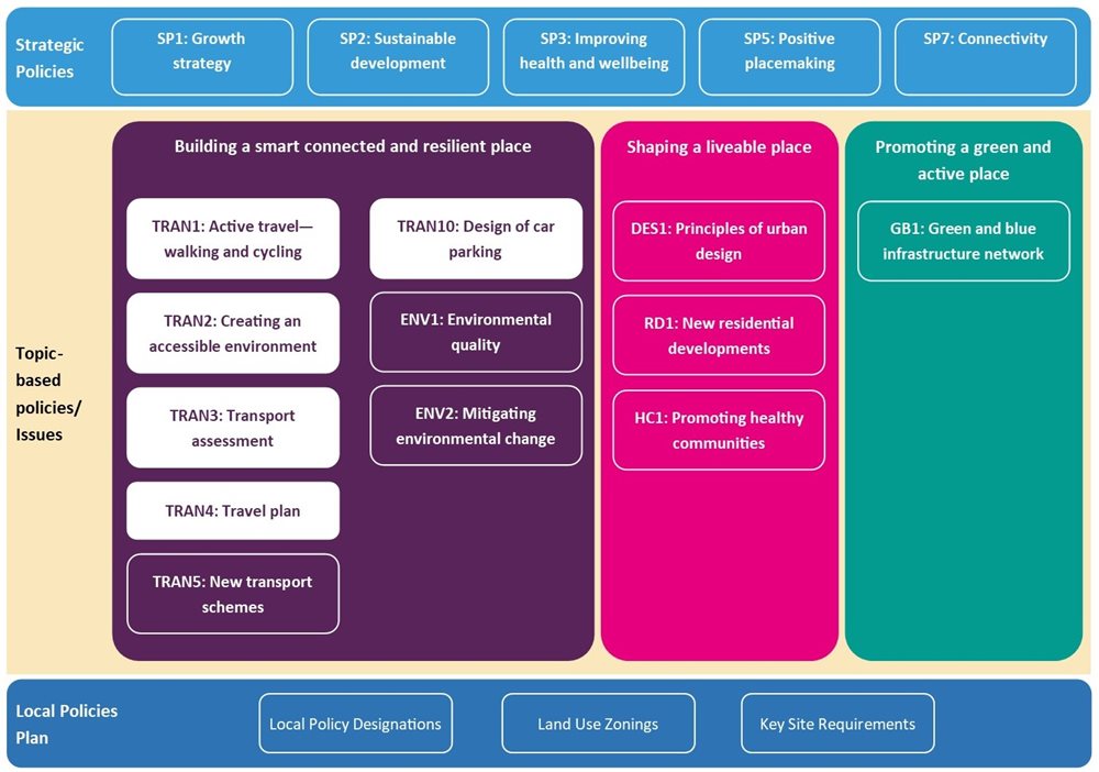
2.3.3 While this guidance seeks to supplement PS policies TRAN 1: Active travel – walking and cycling, TRAN 2: Creating an accessible environment, TRAN 3: Transport assessments, TRAN 4: Travel plan, and TRAN 10: Design of car parking, there may also be other relevant and/or related policies within the Plan Strategy which will require consideration from a transportation perspective (see Figure 2).
Local Policies Plan (LPP)
2.3.4 The LPP sets out the local policies, including site-specific proposals, designations and land use zonings relevant to the development and use of land in Belfast which are required to deliver the council’s vision, objectives, and strategic policies, as set out in the Plan Strategy.
2.3.5 The LPP also sets out Key Site Requirements (KSRs) for certain zoned sites, which in some cases may include specific guidance in relation to provision for transport, permeability and access through active travel and public transport.
3 Issues
3.1 Policy TRAN 1: Active Travel – walking and cycling
3.1.1 Policy TRAN 1 of the Plan Strategy outlines the importance of active travel and includes walking, wheeling and cycling. This guidance highlights important considerations to assist in identifying any physical measures that can enhance sustainable travel choices of the future occupants of a development and the connectivity of that development to its surroundings. The policy states that planning permission will be granted for new development where it takes account of the needs of pedestrians, wheelers and cyclists ensuring that it creates a safe and convenient environment, and where provision is made for supporting infrastructure including cycle parking and that it links to existing or proposed networks and public transport.
3.1.2 The following sections consider the specific requirements for policy TRAN 1 and set out what is required to satisfy policy. Good active travel routes should achieve the core design outcomes as identified in DfT’s technical guidance on Local Walking and Cycling Infrastructure Plans. These requirements are set out in DfT’s Local Transport Note LTN 1/20 and subsequently DfI’s Belfast Cycling Network 2021 which are being coherent; direct; safe; comfortable; and attractive.
3.1.3 Walking, wheeling, and cycling as modes of transport can deliver significant physical and mental health benefits, reduce congestion and noise, improve air quality and are low carbon and low-cost forms of travel. Although there are many similarities in terms of needs of active travellers, they are distinct modes of transport with important differences. In some circumstances pedestrians and cyclists can share the same space safely and effectively. However, most active travel users would prefer to have their own dedicated spaces so that both groups can travel at their own speed and without concerns over conflict with other users. This issue of dedicated spaces is especially important for disabled people. This user need is reflected in LTN 1/20 and Belfast Cycling Network 2021 stating that cycles must be treated as vehicles and not as pedestrians. On urban streets, cyclists should be physically separated from pedestrians and should not share space with pedestrians.
Policy TRAN1 - Active Travel - Walking & Cycling
a. Safe and convenient walking and cycle access;
3.1.4 All new developments should be designed to enhance user accessibility to buildings and surrounding land uses, active travel opportunities and public transport networks. Safe and convenient access to and from developments is important for all users, particularly those choosing to travel by foot or bicycle. Therefore access routes and public spaces should be attractive, comfortable, and appropriately proportioned to provide a safe environment (both actual and perceived). Similarly, access routes and public spaces which are direct and straightforward to navigate are more convenient for users of those environments than those which are poorly designed and lack coherence.
Safe walking and cycling access
3.1.5 Safety is essential for pedestrians, both in the form of preventing physical harm through collisions with vehicles and cyclists and minimising threats to personal safety. Safety is improved by separating pedestrian routes from fast vehicle routes and/or by reducing vehicle speeds and flows to a level of minimal risk. Fears over personal safety can be a major barrier to walking.
3.1.6 Cycles should be treated as vehicles and not as pedestrians. On urban streets, cyclists should be physically separated from pedestrians. Where cycle routes cross pavements, a physically segregated track should always be provided. At crossings and junctions, cyclists should not share the space used by pedestrians but should be provided with a separate parallel route. Cyclists should be physically separated and protected from high volume motor traffic, both at junctions and on the stretches of road between them. The need for cyclists to come into proximity and conflict with motor traffic should be removed, particularly at junctions, where most collisions occur.
Natural surveillance
3.1.7 Streets and paths should provide natural surveillance from adjacent buildings. Cycle and pedestrian routes should be overlooked by buildings with active frontages, providing natural surveillance, improved safety, and perceived safety as this can give a strong sense of security for users. Buildings with dead frontages at street level reduce the feeling of security deterring people from walking and will not be acceptable. Pedestrian routes should have clear exit and entrance points.
Surfaces and Gradients
3.1.8 Surfaces should be hard, smooth, level, durable, permeable and safe in all weathers. Smooth surfaces with minimal stopping and starting, without the need to ascend or descend steep gradients and which present few conflicts with other users create safe, comfortable conditions that are more conducive to walking, wheeling, and cycling.
3.1.9 Sections of rising or falling route create specific challenges, particularly for cyclists. Ascending even short uphill gradients considerably increases the discomfort for cyclists. It is particularly difficult for people using adapted cycles, which tend to be heavier and offer limited ability for short-term increases in power. The Design Manual for Roads and Bridges (DMRB) provides further guidance on slip resistant surfaces.
3.1.10 As a general principle development schemes should be designed to work with natural inclines and topographies to avoid the need for steep gradient and major engineering interventions. Selecting the best routes through a development should avoid excessive ascents or descents. The maximum desirable gradient depends on length. People are better able to tackle short steep gradients, but even relatively gentle gradients can become difficult if they are sustained.
Footway Proportions
3.1.11 A suitable footway width is important to allow pedestrians to travel safely and comfortably at their chosen speed and in groups, such as when walking with younger children. Creating Places advises that where possible, pedestrian routes should have a clear unobstructed minimum width of 2m. Some routes will require greater width than the minimum 2m due to the number of pedestrians that habitually use the route and/or the main category of user. Whilst the preference is for separated footways and cycleways, integrated approaches can be more common at commercial nodes where the distinction is maybe less obvious. In such circumstances cycle speeds are likely to be lower which can allow for greater integration.
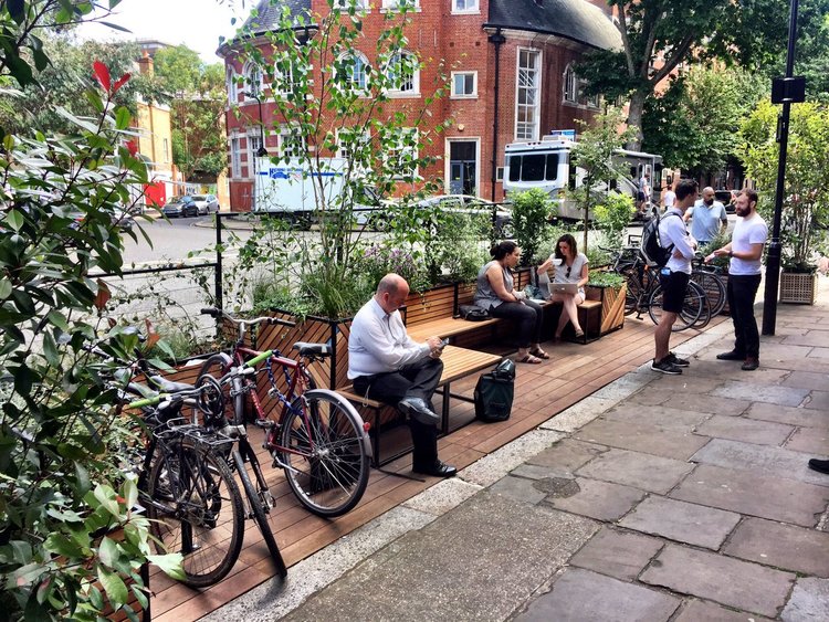
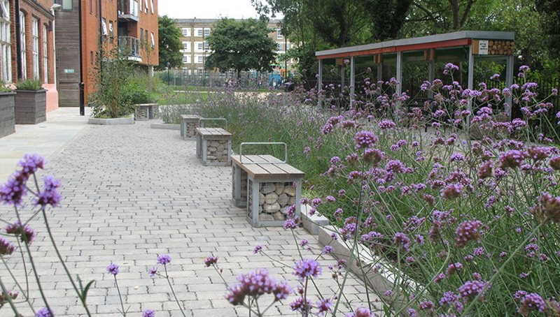
Figure 3: Calvert Avenue Parklet, Shoreditch, London (Meristem Design)
Cycleway Proportions
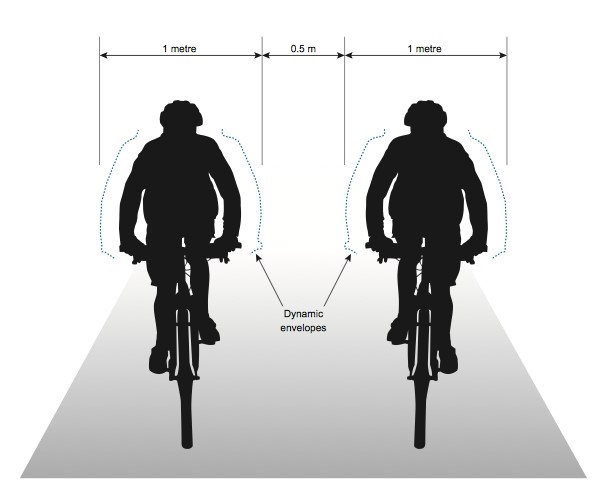
3.1.12 Typical conventional cycles for adults are around 1.8m in length and 0.65m in width. For an adult cyclist, 0.8m is the typical static width. There is evidence that using narrow (below 1.5m) cycle lanes on roads can place cyclists in greater danger as this can lead to closer overtaking by drivers. The space required to cycle is normally more than the minimum of 2m and should take the following into account:
- there is enough space so that cyclists feel they have the space to move comfortably;
- the position, height, width, and profile of any continuous or intermittent physical barriers around pedal height, such as full-height kerb segregation;
- objects with a vertical profile need a wider clearance than rounded or sloping objects, and the risk of clipping a pedal is greater for higher kerbs;
- any physical barriers at handle-bar height or above, typically walls, guardrail, sign or signal poles and lampposts;
- the width of adjacent traffic lane(s) or, how close vehicles will come to encroaching on the cycling facility;
- the speed and width/type of vehicles moving alongside the cyclists; and
- the geometry of the lane or track.
Figure 4: Dynamic kinetic envelope of cyclists (LTN 1/20: Cycle Infrastructure Design, Department for Transport)
Convenient
3.1.13 Consideration of opportunities to improve infrastructure and other provision designed to prioritise walking, cycling and the use of public transport should be provided for all developments. Taking a holistic, connected network approach which recognises the importance of nodes, links and areas that benefit walking, wheeling, and cycling can enable convenient access to services and facilities.
3.1.14 In line with the Sustainable Transport Hierarchy (see Figure 1) the design of all new developments should ensure that walking, wheeling and cycling are integral to development and not an afterthought. Active travel is the main mode of transport for many people, especially in urban areas, so facilitating and encouraging ‘end to end’ mutli-modal sustainable journeys is key to reducing car usage and enhancing accessibility for everyone. For larger schemes developers should show how their development will link with public transport interchanges and not just a local bus stop. The Chartered Institution of Highways and Transportation’s (CIHT) Buses in Urban Environments provides further useful guidance on this issue.
3.1.15 Routes should be planned and designed to allow people to reach their day-to-day destinations easily, along routes that connect, are simple to navigate and are of a consistently high quality, easily negotiated by people with visual impairments or wheelchair users, as well as people unable to walk easily. People with prams or pushchairs should also benefit from improvements to pedestrian and cycling facilities. Any severance of key pedestrian or cycling routes by busy roads or other obstacles such as railways, waterways and sharp changes in level must be reduced or overcome through appropriate and sympathetic schemes. Proposals should explain any specific issues which might affect access to the development for disabled people. Manual for Streets provides good practice examples of how this can be achieved.
Direct
3.1.16 Direct access routes and public spaces which are direct are more convenient for all users. Pedestrians, for example, are moving under their own efforts and require routes and networks which are direct and follow natural desire lines (see Figure 5). Many housing developments have adopted convoluted and impermeable layouts, often from a desire to control traffic speeds. It is important that new developments should incorporate direct routes for people on foot. Layouts involving cul-de-sacs should be avoided. When cul-de-sacs do feature in layouts active travel links are essential to provide permeability. Careful design is needed to ensure that these do not encourage anti-social behaviour or crime.
![]()
3.1.17 Routes for cyclists must also seek to clearly and obviously provide the most direct and convenient route from origin to destination.
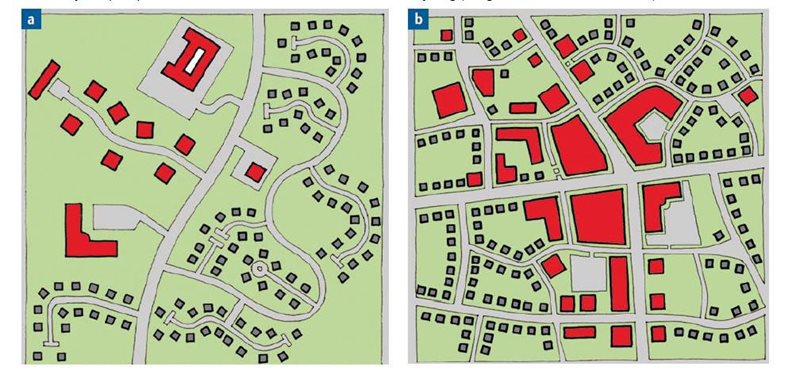
Figure 6: Route connectivity – In typical post-WW2 developments (a) the main roads are often the only through routes. In more historic areas (b) there may be parallel routes that could be made suitable for cycling (Manual for Streets and LTN 1/20, Department for Transport)
3.1.18 To make cycling preferable to driving, routes for cyclists must be at least as direct – and preferably more direct – than those available for private motor vehicles. An indirect designated route for cyclists may result in some of them choosing the more direct, faster route, even if it is unsuitable for cycling. A route through a complex junction must be clear to all users.
Policy TRAN1 - Active Travel - Walking & Cycling
b. Safe, convenient, and secure cycle parking …
3.1.19 As more of the population rely on cycling as their main form of commuting and getting about the city, it is important to ensure that infrastructure needed to support cyclists is safe and located at appropriate locations. This section considers the safety, convenience and security of cycle parking and includes the level of provision that developers will be expected to provide. The availability of appropriate cycle parking facilities at either end of a trip has a significant influence on the decision to travel by bicycle. The absence of such facilities, and the consequent risk of vandalism and theft can undermine investment in the overall network infrastructure.
3.1.20 Cycle parking is therefore integral to any cycle network, and can precede other dedicated cycle infrastructure, to address the cycle parking needs from the outset. Cycle parking is also a key part of providing integration with public transport allowing cycling to act as a feeder service to public transport routes. The availability of secure cycle parking at home, at the end of a trip or at an interchange point has a significant influence on cycle use.
Quantity of Cycle Parking
3.1.21 The quantity and type of cycle parking that is appropriate differs between locations and therefore consideration of the different needs of each setting is important. The amount of cycle parking which should be provided for different types of development is set out in DfI’s Parking Standards guidance. Predominantly, cycle parking should be sited as close as possible to the destination or main access of buildings to afford protection from the weather and security. Additional cycle parking should be provided in pedestrianised areas or areas of parking restraint that is sufficient to meet current demand and satisfy future requirements without cluttering the streetscape or affecting the space available for walking, wheeling, and cycling routes.
3.1.22 Where there is evidence of latent demand for cycle parking, for example cycles secured to street signage or furniture, monitoring by periodic survey can be a valuable tool in identifying where existing provision should be extended or new provision provided. Instances where demand is close to the supply of available spaces may indicate suppressed demand. Where this is the case, increased provision of cycle parking should be considered. If existing provision is already high (over 50 spaces provided), capacity should be increased by at least 20 per cent.
Types of Cycle Parking
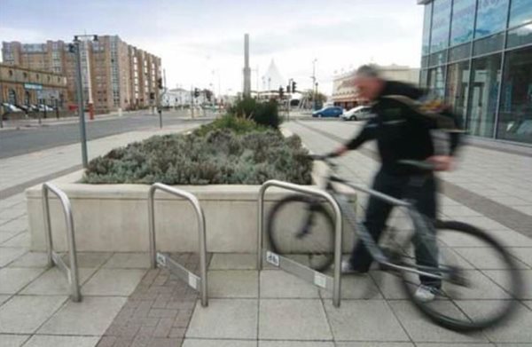
3.1.23 Just as the location, layout and quantity of cycle parking should be considered in the context of its use, so should the type of the cycle parking equipment. A correctly proportioned stand provides support to the front and rear wheels, and just below the saddle. The preferred and most common form of cycle parking is a tubular steel metal stand anchored into the ground at two points. Often referred to as a “Sheffield stand” these allow for both the frame and wheels to be secured (see Figure 7). Stands that support the cycle by gripping the wheels alone are not an acceptable parking solution.
Figure 7: Sheffield stands – setting with natural surveillance, accessible and integrated into street furniture
3.1.24 Unsecured open stands do not provide sufficient security where cycles are to be parked overnight, for long periods of time, or in locations that are poorly overlooked where there is a higher risk of theft and vandalism. Where there is a requirement for overnight or long-term parking the provision of well-lit secure lockers, compounds, and supervised parking would be preferable. The Police Service of Northern Ireland’s Architectural Liaison Service can advise on placement of cycle parking and the use of lockers on a site-by-site basis.
Cycle Parking Design and Layout
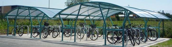
3.1.25 Cycle parking facilities should be located as close as possible to the entrance of the establishment they are intended to serve and must not obstruct routes or entrances. To maximise convenience and security, the use of transparent panels can provide an alternative to materials that would otherwise shield users and bikes from view (see Figure 8).
3.1.26 It is not acceptable to locate cycle parking in dark recesses or at the rear of car parks as these areas tend to be less secure and often underused. Cycle parking should be placed carefully in relation to their surroundings, and where possible, in areas overlooked by occupiers of buildings or in clear view of pedestrians. The appearance of cycle stands may be enhanced by incorporating them into wider environmental improvement schemes. Routes to parking should be surfaced, easily identifiable and incorporate dropped kerbs.
3.1.27 Cycle parking should, as a minimum, be large enough to accommodate the dimensions of a typical adult-size cycle. Cycle parking provision should consider all types of cycle vehicle and all types of cycle user. Increased space provision may be required in locations where large cycles or cycles with goods baskets or child seats are expected to park frequently. In all cases the location of cycle parking should ensure that parked cycles will not obstruct nearby walking, wheeling and cycling routes. Providing insufficient space is likely to result in the cycling parking being frustrating to use with subsequent lower use.
3.1.28 There are many ways of arranging cycle parking but in all cases the following should be considered:
- Security – Cycle parking must allow users to secure their cycle with a variety of lock types;
- Lighting – Essential for personal security and for parking after dark;
- Weather protection – Can the cycle parking be covered? This is important for commuters and overnight parking;
- Obstruction – The needs and space requirements of other users, particularly blind and partially sighted pedestrians must be considered, and parked cycles should not obstruct these routes. Visual aids such as high visibility markings on the first and last stand in a row or contrasting colour/texture paving may be used to delineate cycle parking areas;
- Potential to integrate with existing street furniture, signing or planting; Located on level ground or, if this cannot be achieved, perpendicular to the slope to avoid cycles rolling down the slope; and
- Located in obvious, clean, maintained and overlooked areas to deter vandalism/theft, and to make users feel safe and welcome.
Policy TRAN1 - Active Travel - Walking & Cycling
c. Links to existing or programmed networks and public transport services where they adjoin the development site
3.1.29 Provision for walking, wheeling and cycling is frequently fragmented and of varying quality. There is a need to ensure that provision is integrated and coherent, and where opportunities arise through development opportunities, that a holistic approach is taken to consider the whole route and improve cycling and walking provision. It is also vital that new developments fit into the existing urban areas and are coherent to ensure good links and accessibility with their surroundings. All new developments should connect to existing and programmed networks and public transport services adjoining the development site to enhance access to services and facilities and create opportunities for active travel. It will therefore be necessary in the development of site proposals to consider the city’s existing and proposed green and blue infrastructure and cycle networks to establish infrastructure connections for active travel.
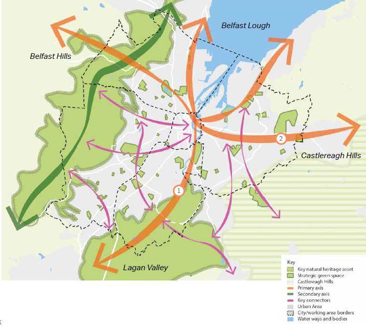
3.1.30 The green and blue strategic framework shown in Figure 9 illustrates the spatial vision for the future of green and blue infrastructure in Belfast. The existing green and blue network and strategic connections offer opportunities for the expansion of our safe pedestrian and cycle network. As part of this framework we will also support new and enhanced green and blue spaces in the city centre and improve overall connectivity across the network.
Figure 9: Belfast Green and Blue Infrastructure Strategic Network (Belfast City Council)
3.1.31 Greenways provide safe pedestrian and cycle routes across the city. The routes are intended to extend the network to connect with open spaces across the city and out to the surrounding countryside where they can link to the broader Northern Ireland greenways and cycle network. The existing network is already proving to be a success with the Lagan Tow Path attracting an estimated 1 million visitors per annum, demonstrating the economic potential of green and blue infrastructure. The extension and enhancement of this network will support a greater uptake of active transport modes and reduced reliance on cars, which will improve the health and wellbeing of us all through improved fitness and air quality.
Figure 10: Belfast Cycling Network 2021 – Proposed Primary Network (Department for Infrastructure)
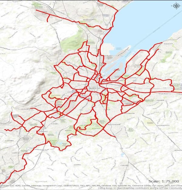
3.1.32 Section 76 agreements may be used to contribute to connecting new developments to our expanding Green and Blue network. This will help ensure coherent integration between proposed developments and existing urban areas. In the case of larger developments masterplans may also help to incorporate the development into their wider context and provide appropriate walking, wheeling and cycling routes. Such routes should flow, feel direct and allow people to reach their day-to-day destinations easily and logically. Pedestrian routes should connect seamlessly with one another to form a comprehensive, permeable, and logical network. Routes must be legible i.e. clearly defined and identifiable by all. Layouts of walking routes should be simple, logical, and consistent. Opportunities should be maximised to ensure that new development contributes towards cycling provision, linking the site, and where appropriate, new routes to the network. Planning applications should illustrate how the proposal will integrate into the city’s wider walking, wheeling and cycling network (see Figure 10).
3.2 Policy TRAN 2: Creating an accessible environment
Policy TRAN 2 Creating an accessible environment
Planning permission will be granted for developments that provide suitable access for all including alterations, extensions, and changes of use.
3.2.1 It is essential that new developments are designed to be barrier free. This will not only meet the needs of people with disabilities, but people at all stages of life. Developments should promote improvements rather than just guard against problems, to enable inclusion and independence. It is also important to recognise that disabled people are not a homogeneous group and will have a range of requirements. It is important that the full range of mobility needs is considered and accounted for when considering user needs.
Creating an inclusive environment
3.2.2 An accessible environment is an inclusive environment and accommodates differences in the way people use the built environment. It facilitates dignified, equal, and intuitive use by everyone. Despite progress in building more accessible cities in the last decade, people with disabilities and older people still experience considerable barriers to living independent lives as a result of the way the built environment is designed, built, and managed. An accessible environment does not physically or socially separate, discriminate, or isolate. It readily celebrates diverse user needs — from childhood to adulthood through to older age, including disabled and non-disabled people, embracing every background, gender, sexual orientation, ethnicity and culture. Around 22 per cent of the UK population have some degree of disability. Considering the needs of disabled people within the design process will secure benefits for everyone.
Inclusive Design
3.2.3 With a growing older and working-age population, many of whom will have or will experience mobility issues, it makes strategic long-term sense to ensure our environments are accessible for all as it is likely that everyone at some point will experience some degree of limited mobility – such as a tourist laden with bulky luggage, a parent with young children or an individual with injuries.
3.2.4 A Design and Access Statement is required for some planning applications and can identify barriers to inclusion as early as possible within the design process so that good design can overcome them (refer to Belfast City Council’s Application Checklist). The Design and Access Statement should explain the policy or approach adopted regarding access to, from and within the development, and how policies relating to access in the Local Development Plan have been taken into account and explain any specific issues which might affect access to the development for disabled people. Following this approach, should ensure the building is fit for purpose and meets the highest standards of accessibility and inclusion and continues to do so. Further guidance is available from DfI Development Practice Note 12 – Design and Access Statements.
3.2.5 British Standard 8300 provides detailed technical advice on accessibility of the external environment and buildings. The standards cover the use of public buildings by people with disabilities who are residents, visitors, spectators or employees. Recommendations include parking areas, setting-down points and garaging, access routes to and around all buildings, as well as entrances and interiors.
Accessible Gradient
3.2.6 Good design principles advocate incorporating topographical features as an integral part of development schemes. Sometimes steep gradients are difficult to avoid however they can have an impact on people with mobility difficulties, older people, parents with pushchairs and people with disabilities and should be minimised. Ideally the use of steps should be avoided. Where the gradient of a surface increases, tactile surfaces should be used to increase friction and traction and make surfaces slip resistant. Both BS 8300 and DMRB provide guidance on slip resistant surfaces.
3.2.7 The Design and Access Statement should include a marked-up plan at an appropriate scale and include sections showing relevant gradients and any changes in level. This should illustrate:
- the main step-free pedestrian routes internally and externally, showing how people move up and down as well as around the building(s) and the spaces between the buildings;
- the use of tactile surfaces;
- access to car parking and public transport facilities;
- staff and visitor entrances; and
- other relevant facilities and features, including toilet facilities.
3.2.8 However where a difference in level is unavoidable due to site constraints, the approach may have a gentle gradient over a long distance (for all or part/s of the approach), or it may incorporate a number of shorter parts at a steeper gradient, with level areas at intervals as rest points. BS 8300 provides guidance on use of sloping surfaces and ramps over distance.
Suitable Materials
3.2.9 The choice of surface materials on walking routes is important to pedestrian comfort and safety and can also contribute to the character of a street environment. In general, surfaces should be even, firm and slip resistant in wet and dry conditions. Consultation with DfI Roads should be undertaken to ensure the materials used are acceptable in terms of adoption and maintenance (if being put forward for adoption). See DMRB for guidance.
3.2.10 Contrast is important to delineate space where users are sharing space and for visually impaired people, many of whom can distinguish changes in colour and tone. Footway materials should therefore be consistent, avoiding the use of random patterns which have no meaning. Good contrast between pedestrian routes, cycle tracks and carriageways will help visually impaired people to make sense of their environment.
3.2.11 The provision of areas and benches for pedestrians to rest and sit is a particularly important user need for older pedestrians and people with physical disabilities. Creating an accessible environment should design out barriers and exclusion and will often achieve superior solutions that benefit everyone. Through the adoption of inclusive design, people will be able to make effective, independent choices about how they use a development without experiencing undue effort, separation, or special treatment. They will be able to participate equally in the activities that the development offers.
Shared Surfaces
3.2.12 Shared surfaces will need to be designed in detail to create surroundings that all users consider to be safe, and that will encourage drivers to proceed with care. Differences between the visual character of shared surfaces and roads with footways should be clearly emphasised by the design. Where cycle routes use such paths in built-up areas, separation from pedestrians should be provided, perhaps with levels or a kerb. A person should be able to travel conveniently without assistance to and from the curtilage of a building and to an entrance of a building.
Street Furniture
3.2.13 Ill-thought-out positioning and location of street furniture can clutter the streetscape. Clutter is visually intrusive and has adverse implications for many disabled people, presenting a hazard, particularly to a wheelchair-user or a person with a visual impairment. Where possible, furniture should be located outwith the width of an accessible route. Use of low-level bollards or chain-linked posts, for example, can be particularly hazardous.
3.2.14 However, street furniture that encourages human activity can also contribute to a sense of place. The most obvious example of this is seating, or features that can act as secondary seating in a mix of styles to satisfy a range of needs. This is especially useful at transport interchanges, where people might spend some time waiting for a lift or a car share or a bus turning circle and stop within a site.
3.3 Policy TRAN 3: Transport Assessment
Policy TRAN 3 Transport Assessment
A transport assessment will be required to evaluate the transport implications of the development proposal, where it is likely to have significant travel generating uses.
3.3.1 A Transport Assessment (TA) is a comprehensive and systematic process that sets out various transport issues relating to a proposed development. It identifies what measures will be taken to deal with the anticipated transport impacts of the scheme in relation to all forms of travel. Where that mitigation relates to matters that can be addressed by management arrangements, the mitigation may inform the preparation of Travel Plans.
3.3.2 Guidance in this section will assist in identifying developments that are likely to have significant travel generating uses and highlight key elements of the DfI’s Transport Assessment – Guidelines for Development Proposals. A DfI Transport Assessment Form (TAF) must be submitted with each planning application where the proposed development is likely to have significant travel generating uses. The purpose of a TAF is to screen out applications where no further information on the transport impacts is necessary and identify applications which will require a detailed Transport Assessment.
3.3.3 A TA can be required for any size planned development that has potential transport impacts. As a general guide they are likely to be required for developments which have 100 or more vehicle movements in the peak hour. However proposals that do not meet the size thresholds may have sufficient transport impacts to require the completion of a TA.
3.3.4 Other considerations may raise significant transport implications, such as where the development is likely to:
- generate significant traffic at peak times in a congested area, a sensitive location or an important traffic route or road junction;
- generate significant freight movements;
- generate traffic late at night in a residential area, particularly lorries; and/or
- raise significant concerns over road safety.
Scoping discussions/Pre-Application Discussions (PADs)
3.3.5 Scoping discussions or Pre-Application Discussions (PADs) with Belfast Planning Service should happen early in the application process, to front-load applications with information to reduce time and potentially expensive changes later. Depending on the scale and nature of the proposed development, these discussions could involve other parties, such as DfI Roads and public transport providers. Transport Assessment discussions should cover:
- the requirements for complying with the Local Development Plan policies to promote sustainable transport;
- the scope of information needed from a developer; and
- the availability of local data that may assist in the preparation of a Transport Assessment.
3.3.6 Transport Assessment discussions will be used to identify measures to promote sustainable modes of access, particularly non-motorised modes, to and from the site. Discussion should cover:
- adequate provision of pedestrian access (including facilities for people with impaired mobility);
- adequate provision of cycle access;
- improvements or modifications to public transport services;
- the need for a Travel Plan and Service Vehicle Management Plan (including proposed service vehicle trip rates/ generation);
- the use of planning conditions and planning and other legal agreements to secure these measures; and
- parking provision.
3.3.7 More detailed information on measures to provide sustainable transport options are contained in Appendix 1 (Table 3: Measures that may be required as part of a Travel Plan.)
3.3.8 Measures identified as part of the development (whether on-site or off-site) should be accurately specified along with the timescale by which they should be in place. Planning permission may be subject to a condition or legal agreement preventing the development from going ahead or occupation until works necessary to facilitate the development have been undertaken.
Preparing a detailed Transport Assessment
3.3.9 The scope and level of detail in a Transport Assessment or Statement will vary from site to site but the key issues to consider at the start of preparing a Transport Assessment may include:
- the planning context of the development proposal;
- appropriate study parameters (i.e. area, scope and duration of study);
- assessment of public transport capacity, walking/cycling capacity and road network capacity;
- road trip generation and trip distribution methodologies and/or assumptions about the development proposal;
- measures to promote sustainable travel;
- safety implications of development; and
- mitigation measures (where applicable) – including scope and implementation strategy.
3.3.10 In the event that a detailed Transport Assessment is required, the applicant will need to undertake the three key stages outlined in DfI’s Transport Assessment – Guidelines for Development Proposals. It highlights the three stages in preparing a detailed Transport Assessment:
Stage 1 – Assessing the Travel Characteristics of a Development:
- information about the proposed development, site layout;
- information about neighbouring uses, amenity and character, existing functional classification of the nearby road network;
- data about existing public transport provision, including provision/ frequency of services and proposed public transport changes;
- a qualitative and quantitative description of the travel characteristics of the proposed development, including movements across all modes of transport that would result from the development and in the vicinity of the site;
- an assessment of trips from all directly relevant committed development in the area (i.e. development that there is a reasonable degree of certainty will proceed within the next 3 years);
- data about current traffic flows on links and at junctions (including by different modes of transport and the volume and type of vehicles) within the study area and identification of critical links and junctions on the highways network;
- an analysis of the injury accident records on the public highway in the vicinity of the site access for the most recent 3-year period, or 5-year period if the proposed site has been identified as within a high accident area;
- an assessment of the likely associated environmental impacts of transport related to the development, particularly in relation to proximity to environmentally sensitive areas (such as air quality management areas or noise sensitive areas);
- a description of parking facilities in the area and the parking strategy of the development;
Stage 2 – Influencing Travel to the Development:
- measures to improve the accessibility of the location (such as provision/enhancement of nearby footpath and cycle path linkages) where these are necessary to make the development acceptable in planning terms;
- ways of encouraging environmental sustainability by reducing the need to travel; and
Stage 3 – Appraising and Mitigating Impacts:
- measures to mitigate the residual impacts of development such as improvements to the public transport network, introducing walking and cycling facilities and physical improvements to existing roads.
3.4 Policy TRAN 4: Travel Plan
Policy TRAN 4 Travel Plan
Planning permission for development proposals with significant travel generating uses will require a travel plan.
3.4.1 A Travel Plan is a document prepared by a developer or organisation which sets out a package of complementary measures for the delivery of sustainable travel. The objective of a Travel Plan is to reduce single occupancy car travel. However, a Travel Plan should not be used to make a development acceptable. A Travel Plan is a long-term management strategy for an organisation or site that seeks to deliver sustainable transport objectives and is regularly reviewed. As such, critical elements of all successful Travel Plans include setting targets to improve sustainable travel, monitoring and review.
3.4.2 Travel Plans are required for developments that generate trips (i.e. housing) or attract trips. The scope of a Travel Plan should include measures relating to commuting, business journeys, visitors’ trips, deliveries to and from business premises and the efficient management of company fleet vehicles.
3.4.3 In determining whether a Travel Plan will be needed for a proposed development the following factors will be taken into account:
- the Travel Plan policy TRAN 4 of the Belfast Local Development Plan 2035;
- the scale of the proposed development and its potential for additional trip generation (smaller applications with limited impacts may not need a Travel Plan);
- existing intensity of transport use and the availability of public transport;
- proximity to nearby environmental designations or sensitive areas;
- impact on other priorities/strategies (such as promoting walking and cycling);
- the cumulative impacts of multiple developments within a particular area;
- whether there are particular types of impacts around which to focus the Travel Plan (e.g. minimising traffic generated at peak times); and
- relevant national policies, including the decision to abolish maximum parking standards for both residential and non-residential development.
3.4.4 The type of Travel Plan required will depend on the scale and nature of the proposal:
- Full Travel Plan
- Framework Travel Plan (also termed an Interim or Outline Travel Plan)
- Travel Plan Statement.
- A Full Travel Plan should be submitted to support a full planning application with significant travel generating uses. This will include clear targets, timescales, and measures to achieve those targets, and a monitoring & review framework.
- A Framework Travel Plan may be more appropriate for certain applications (particularly outline applications) where the occupants, or some of the occupants are unknown. Framework Travel Plans should include clear targets but some aspects may remain provisional (i.e. details of measures). This type of Travel Plan can be submitted in the case of large speculative developments with multiple (more than five) occupants (organisations) and where the occupant(s) remains unknown. It should focus on targets and measures across the whole site and should be administered centrally.
As individual occupiers come to the site, they should develop Full Travel Plans that are consistent with the Framework Travel Plan. As large sites can take some time to occupy, the Framework Travel Plan should include as a key component a clear timetable setting out when measures will be enacted. An important component of the Outline Travel Plan will be a timeframe in which to develop and agree a Full Travel Plan with the Council and DfI.
The first step of the Travel Plan is to undertake a survey to establish baseline travel habits and the likelihood for change. Therefore, the workforce target audience need to be present to develop the Travel Plan. A Travel Plan for a speculative development should be undertaken within six months of occupation of the development or part thereof. This will allow the Travel Plan to measure and affect travel habits as soon as possible after occupation. For a Framework Travel Plan, or a development that is phased, targets should be stated to show how the developer expects trips to evolve as the site is developed and as measures are instigated.
- A Travel Plan Statement can be used to support small developments which do not justify a Full Travel Plan. They can be used where there is a need to encourage sustainable forms of travel, but a Full Travel Plan would not be required. It should set out the existing conditions within and near to the development and contain a commitment to the promotion of sustainable travel. It also sets out objectives and measures and targets to encourage travel by sustainable modes.
3.4.5 Whichever Travel Plan type is being submitted, the “audience” (i.e. staff, particular staff groups, residents, visitors) should be clearly identified within the document. It should also include measures and targets referenced and applicable to each of these audiences.
Critical elements of a successful Travel Plan
3.4.6 Though not an exhaustive list, Table 2 of Appendix 1 sets out the various sections common to most Travel Plans and those acceptable to accompany planning applications in the Belfast City Council area. They should evaluate and consider:
- benchmark travel data including trip generation information;
- information concerning the nature of the proposed development and the forecast level of trips by all modes of transport likely to be associated with the development;
- relevant information about existing travel habits in the surrounding area;
- proposals to reduce the need for travel to and from the site via all modes of transport; and
- provision of improved public transport services.
Travel Plan Co-ordinator
3.4.7 Part-time or Full-time on sites with more than one occupier (i.e. for Framework Travel Plans) one Travel Plan co-ordinator should be appointed by the developer/landowner to cover all occupiers and the cost of this met centrally by the developer. The mechanism by which this individual would liaise with the individual units making up the development site should be identified within the Travel Plan.
Financial Resources
3.4.8 The Travel Plan should include a commitment that the budgetary requirements of its implementation are secure. This will ensure that all Travel Plans have considered arrangements for the implementation, coordination, and day-to-day management of measures prior to development occupation.
Communications Strategy
3.4.9 The Travel Plan should identify each audience within the Travel Plan (i.e. staff, residents, visitors, customers, patients etc.) and clearly state how it is going to change the travel habits of each of these audiences within the document. The document should identify how the Travel Plan’s measures and performance will be communicated to these audiences.
Site Assessment
3.4.10 The site assessment undertaken for the Transport Assessment process should reveal measures that will make the site accessible by sustainable modes. Physical measures should be undertaken before occupation of the building.
Soft and Hard Measures
3.4.11 Soft measures are long-term non-physical (non-engineering) interventions aimed at reducing car use. Examples of soft measures could be a car park management policy, car club membership or car share scheme membership and promotion.
3.4.12 Physical, often termed “hard” measures (such as walking, cycling and public transport infrastructure) should be considered jointly with the Transport Assessment and be in place prior to occupation and identified in the Planning Condition or S76 Agreement as appropriate. Table 3 in Appendix 1 provides examples of both soft and hard measures.
Targets
3.4.13 Travel Plans use the terms Objectives, Aims, Targets and Goals interchangeably. For the avoidance of doubt, this section identifies how Travel Plans submitted in support of applications should be formulated in terms of Targets. Targets should be set for the audiences (i.e. staff, residents, visitors, customers, patients etc.) of the Travel Plan. The main aim stated within any Travel Plan should be to; “minimise single-occupancy car trips by promoting and supporting alternative modes”.
3.4.14 The primary target within a Travel Plan should be based around the (multimodal) trip generation values set out in the development’s Transport Assessment. The (vehicular) trip generation values given in the TA should be considered as maximum values and the target (vehicular) trip generation values in the Travel Plan should be lower than that which would be expected from a development without a Travel Plan.
3.4.15 All Travel Plans should include consideration and actions in relation to the following topic areas:
- Promotion of walking;
- Promotion of cycling;
- Promotion of public transport use;
- Measures to reduce Single Occupancy Vehicle/car use;
- Measures to reduce the need to travel e.g.
- Demand/Car Park Management
- Strategy/policy/operational implementation
- Pool car/bike fleet to reduce the need to drive to work
- Workplace public transport ticket purchase for travel to meetings
- Car Sharing to, from and for work (meetings)
- Remote or flexible working from home or closer to home
- conducting meetings online.
- Fleet Management;
- Marketing the Travel Plan; and
- Identification and removal of workplace policies that discourage sustainable travel, such as priority parking, lease cars, enhanced mileage rates.
Travel Plan Monitoring
3.4.16 Monitoring is an essential part of any Travel Plan process and tracks if initiatives have been successful, reviews the progress towards objectives and targets, and allows organisations to update the way forward, as necessary. Following implementation of hard and soft measures, monitoring needs to take place at regular, agreed intervals over a period set out in the Planning Agreement. It is advised that monitoring is initially carried out annually.
3.5 Policy TRAN 10: Design of car parking
Policy TRAN 10 – Design of car parking
3.5.1 This section provides guidance on designing safe and secure parking areas, whilst also highlighting key elements of the DfI’s Parking Standards. The location and design of car parking at homes and street layout in residential areas has an influence on people’s propensity to drive.
3.5.2 The principles outlined in Creating Places should be referred to. BS 8300 Part 1: External environment, a holistic best practice guide to accessibility should be considered for the layout and design of parking areas. Through good design, car parking (public and private) must consider safety for pedestrians, cyclists, and vehicles. For example, through appropriate separation of vehicles/persons and lighting/CCTV as appropriate. It should also address issues of security, visual amenity, and access requirements.
3.5.3 Access and circulation arrangements must accommodate the needs of all users with a particular emphasis on vulnerable groups. Entrances and exits must not present a hazard to road users, pedestrians and cyclists or interfere with safety and the movement of traffic on the public road. It is important that the provision and design of car parking space is well integrated to ensure a high-quality public realm is maintained or achieved.
(a) It respects the character of the local townscape / landscape.
3.5.4 Car parks, particularly multi-storey car parks need to be designed to ensure that they make a positive contribution to the appearance of the urban environment. Multi-storey and surface car parks obviously present very different design challenges. In the case of multi-storey car parks, the principal considerations are likely to be how to ensure that the scale and form of a car park building integrates well with its surroundings. In some cases, it may be most appropriate for a multi-storey car park to blend with surrounding buildings, in other cases a bolder design statement may be more appropriate.
3.5.5 In either case particular attention needs to be paid to the following:
- Where appropriate, acknowledgement of the scale and character of the adjoining buildings and the need to articulate building forms to sympathise with this;
- Choice of elevational treatment and external materials;
- Indoor, multi-storey, or underground car parking should have active frontages at street level to allow passive surveillance of the street. Car parking with dead frontages will not be acceptable. Active frontages improve safety and enhance the feeling of safety, making active routes past these developments more inviting and more heavily used; and
- Roof form. The absence of a roof often leads to multi-storey car parks being out of sympathy with adjoining buildings.
3.5.6 In the case of open surface car parks, consideration needs to be given to the following:
- How best to relate the open space which a car park represents to the patterns and scale of buildings and other open spaces in the vicinity;
- Choice of materials and street furniture;
- Hard and soft landscaping and in particular the treatment of boundaries;
- Surface car parks should blend in with their surroundings with edging treatments that enhance the environment whilst at the same time discouraging people from cutting through;
- Trees and shrubs should be used to break up and soften the visual impact of on- street parking and cars parked in grouped parking areas;
- The use of design features such as changes of ground level and low walls to reduce the extent to which large groups of parked cars and bicycles can be seen from a distance;
- Paving materials should be used to break up the visual impact of hard surfaces in grouped parking areas; and
- The provision of natural surveillance to the car park from passing routes to enhance car park safety.
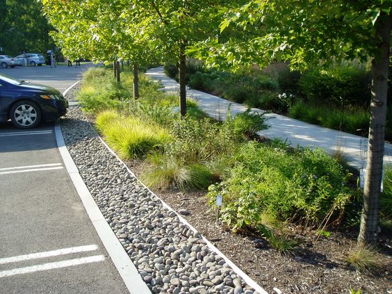
Figure 12: Car parking border treatment – discourages cutting through and allows natural surveillance while softening the impact of the car park.
(b) It will not adversely affect visual and residential amenity.
3.5.7 All development proposals need to respect the impact that the development will have on nearby residential amenity. In terms of car parking most impact on nearby residents is likely to come from the activity of cars entering or exiting the site. A good way to minimise this is by detaching these competing activities as much as possible. Moving the entrance to the rear and assigning residential outlook to the front of the building helps to improve the quality of residential environment in terms of outlook, reducing noise and disturbance but also providing for active frontages.
(c) Provision has been made for security, and the direct and safe access and movement of pedestrians and cyclists within the site.
3.5.8 The amount and arrangement of car parking can have a significant impact on the quality of both the built and natural environment. They should provide a safe and convenient access or egress and a direct, safe internal movement for cyclists and pedestrians including people with disabilities and those with a mobility impairment. It is important that users of car parks feel secure and that appropriate consideration is given to the movement of pedestrians and cyclists.
3.5.9 Crime Prevention through Environmental Design (CPTED) is a crime prevention theory focusing on tactical design and the effective use of the built environment, which when applied reduces both crime and the fear of crime. There are four key principles:
- Surveillance – people are seen and can be seen;
- Access Management – users of an environment are passively directed to some places, whilst being restricted in others;
- Territoriality – ownership of spaces is defined by clear boundaries; and
- Environmental Quality – well maintained and high-quality environments that attract users and aid surveillance.
3.5.10 Security is of particular importance in the design of car parks. Developers will therefore be expected to address this matter, particularly in relation to multi-storey and basement car parking, and are encouraged to seek advice from the Police Service of Northern Ireland, Architectural Liaison Service to discuss Secured by Design.
(d) Provision has been made for accessible parking bays which facilitate safe, convenient access for people with a disability or impaired mobility.
3.5.11 Spaces designed and marked for use by people with disabilities should be provided in grouped parking areas. Dwellings intended for occupation by wheelchair users should have specially designed in-curtilage provision for parking.
3.5.12 Applicants should refer to Creating Places for parking bay dimensions and best practice designs in relation to in-curtilage driveways, hardstanding, grouped parking areas and demarcation of communal parking spaces.
Cycle Parking Standards
3.5.13 Cycle parking quantum standards are outlined in DfI’s Parking Standards.
3.5.14 All long-stay cycle parking (i.e. that provided for residents or employees as opposed to shoppers, users of leisure facilities, etc) should be both covered and secure where this is practical and possible. In the case of cycle parking standards where the number of spaces per employee is not specified under that particular Use Class, the Council will negotiate with the applicant for a target of 25 per cent of the required cycle parking provision to be covered and secure.
Appendix 1
Measures that may be required as part of a Travel Plan (Table 3)
Pedestrian Measures
- Ensure the provision of appropriate, well lit, safe paths for active modes on approach to the development (including from connecting modes, e.g. bus stops)
- Pedestrian access points
- Provision of on-site security patrols
- Design that provides natural surveillance of routes to, from and within the site
- Safe, inviting access and egress through areas that may traditionally be designed for cars, providing lighting and walkways
- Adoption of home zone principles or home zone features
Cycling Measures
- Secured, covered parking (Sheffield stands at workplaces)
- Provision of changing facilities and lockers
- Cycle access points and safe, inviting navigation of the site
- Bicycle User Group
- Provision of on-site repair kit
- Cycle mileage rate for business travel
Bus Measures
- Ensure bus and rail infrastructure and service provision is adequate to meet travel plan targets
- Provision of safe and inviting routes on and off site to access public transport
- Market and promote public transport options
- Provision of discounted ticketing through salary
Promotion of motorcycles/powered two wheelers
- Appropriate secure covered parking
- Changing and locker facilities
To reduce car use
- Sustainable, accessible site location
- Implement effective car park management policy based on operational needs of post, not hierarchy - car park marked, signed, and managed accordingly
- Provision of matching service such as Liftshare.com
- Review company car policy in line with the aim of reducing car use and meeting Transport Assessment/Travel Plan targets
- Review mileage rates as above
- Encourage work planning to facilitate route planning and reducing car use to as few days per week/month as possible
- Develop a culture of shared journeys for pool cars/journeys
- Use of calls, tele/video conference to reduce the need to travel for work
- Provision of pool cars/bikes
- Car club membership/provision - residential and office
- Parking measures
- Demarcating spaces according to the sustainable transport hierarchy - cycling, car share, car club, electric vehicle and scooter with associated infrastructure, operational users
Figure 13: Securing Travel Plans through the Planning process
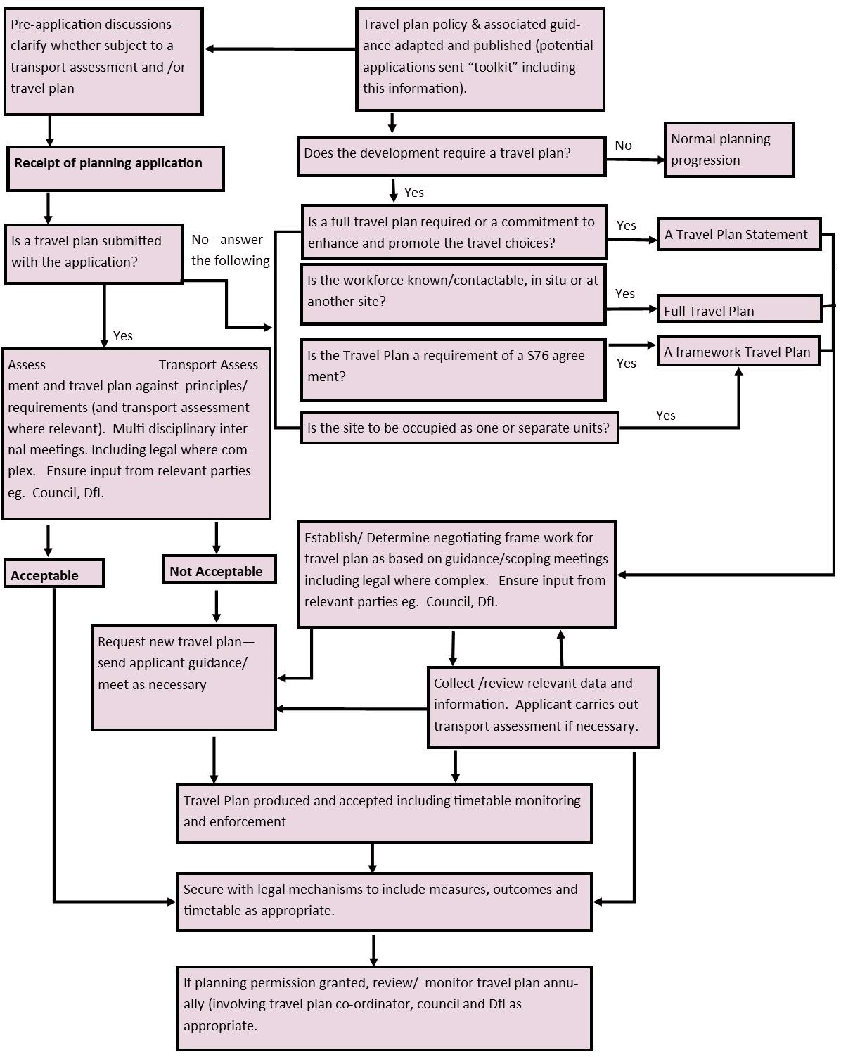 Source: Diagram adapted from ‘Using the planning process to secure Travel Plans: Best practice guidance for local authorities, developers and occupiers (Department for Transport, 2002)’
Source: Table adapted from Good Practice Guidelines: Delivering Travel Plans through the Planning Process (Department for Transport, 2009)