Published in October 2018
Contents
- Preface
- Introduction
- Context
- Vision and place-making themes
- A framework of connected places
- Reshaping East Bank
- Making it happen
- Forward planning
- Appendices
- Appendix 1 A redefined movement framework
- Appendix 2 Key projects
- Appendix 3 Key sites and design principles
Preface
East Bank was identified in the Belfast Metropolitan Area Plan (BMAP) (2014) and the City Centre Regeneration and Investment Strategy (CCRIS) (2015) as an area for new growth in the city centre. The area needs to be better connected to the city centre and provide better linkages northwards to the Titanic Quarter and eastwards to the Short Strand area and wider East Belfast.
It is recognised that the area facilitates strategic vehicular access to and from the city centre via the M3 motorway. However, it comes at a significant cost. Central to unlocking the area’s full potential is the need to address the negative impacts of the shatter-zone and tackle the dominance of road and rail infrastructure. Their combined effect is a poor quality city centre gateway.
The East Bank Development Strategy promotes a rebalancing of the highway network to transform the pedestrian, cycle and public transport user experience whilst incorporating strategic access. It seeks to fully co-ordinate development of key sites and realise a world class waterfront delivering social, economic and environmental benefits to the area and the wider city centre.
The scale of challenge and potential requires an ambitious and integrated approach to urban design and placemaking. Bold but carefully planned and implemented change will be necessary over the short, medium and long terms.
Introduction
Belfast City Council commissioned Arup to develop a detailed strategy for the East Bank area which encompasses the Sirocco site, Queen’s Quay and the area commonly referred to as the “shatter zone”.
An important part of the project will be to consider how this area can be integrated with the city centre and to the adjacent inner city communities and to identify potential interventions to help achieve this.
The work takes a comprehensive approach to the wider area and seeks to integrate future development activity with council’s vision for the city centre as outlined in the City Centre Regeneration and Investment Strategy with a particular emphasis on addressing the need for greater consideration of future infrastructure needs and existing opportunities in this area.
The purpose of this project is to undertake detailed work and develop a framework for the identified East Bank area which falls within the Oxford Street and Eastern Bank Special Action Area. This will help inform a longer term assessment of the potential for change that could inform future planning and development decisions in this area.
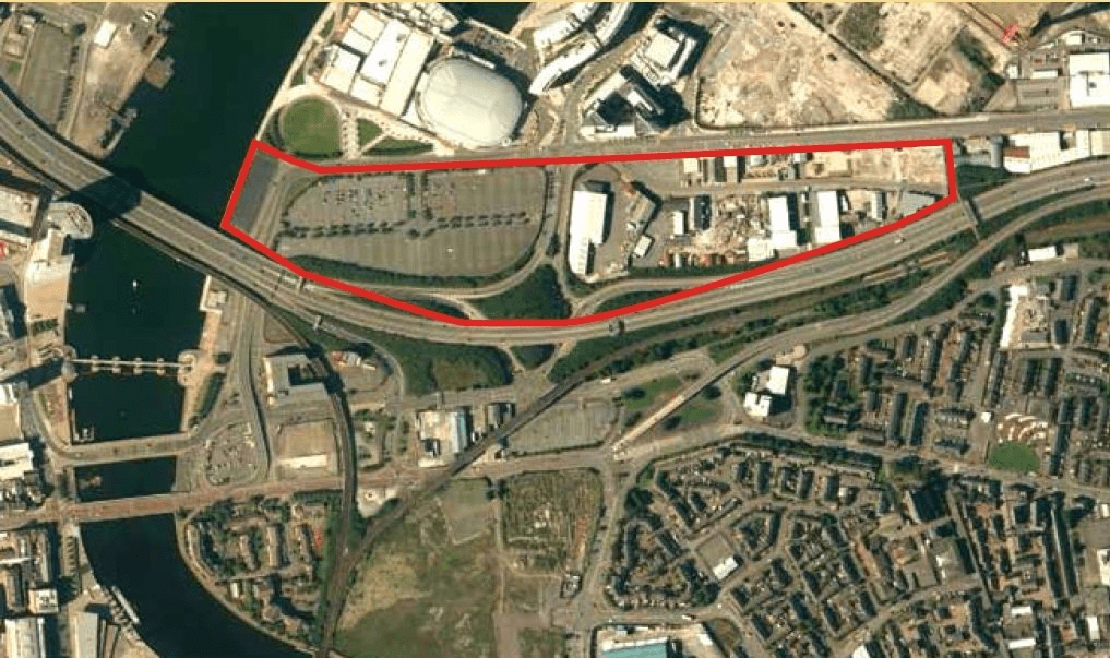
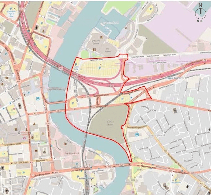
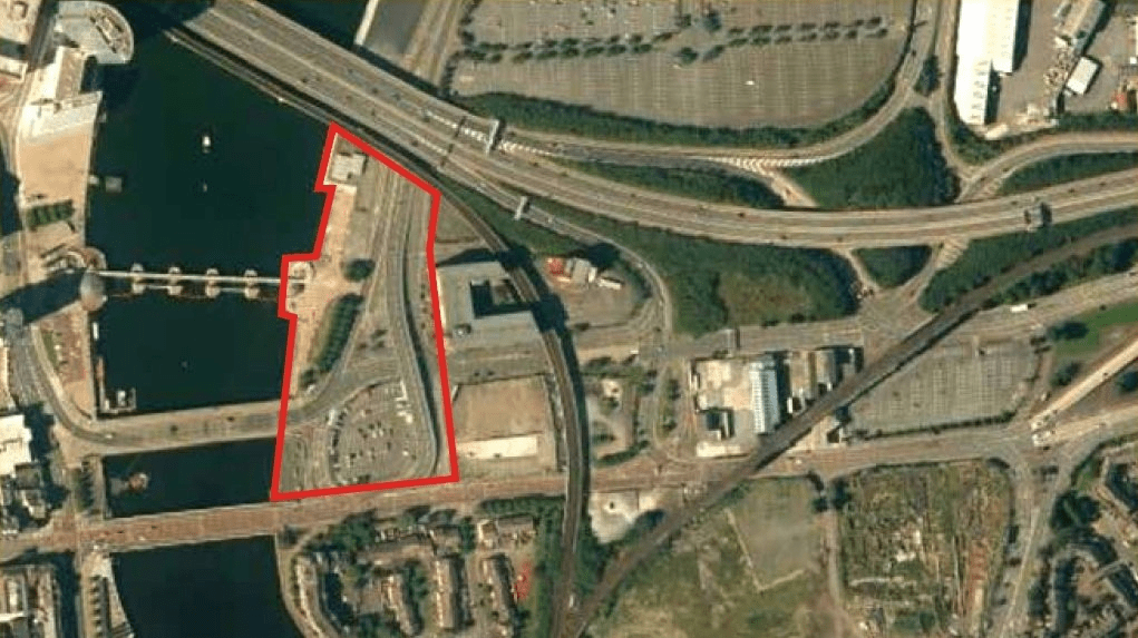
Figure 1 Aerial colour photograph shows study boundary and local context for East Bank in Belfast
Context
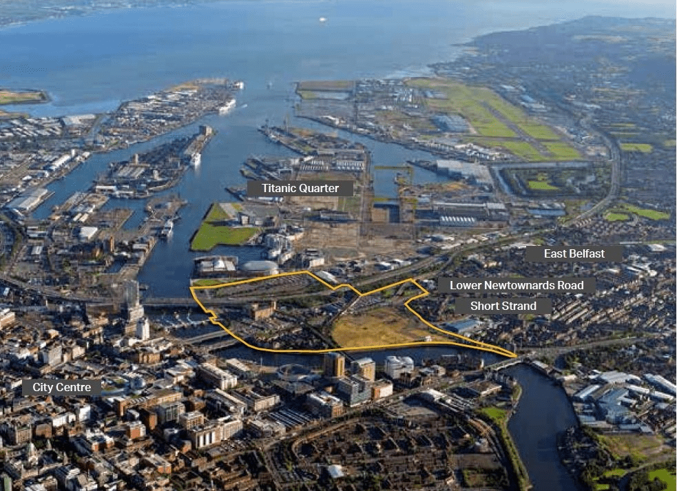
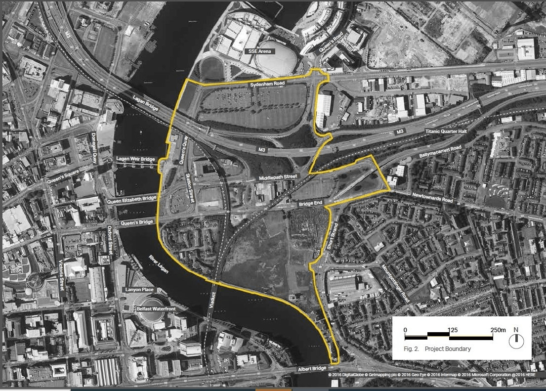
The East Bank development site area encapsulates a significant area to the east of the River Lagan from the current SSE Arena carpark to the north, the central area which is a collective of privately-owned sites and Department for Infrastructure (DfI) or Department for Communities (DfC) public owned carparks known as the ‘shatter zone’ and also the Sirocco Works site to the south bounded by Short Strand road to the east.
The area is steeped in history and during the 19th and 20th centuries in East Belfast, heavy industries such as shipbuilding and rope works dominated the site, in particular the Howden Sirocco Works which forms a significant portion of the East Bank. There is a scheduled chimney and an associated scheduled archaeological area on the Sirocco site and also some historic features such as the boundary wall, that though not formally protected might allow an understanding, within a wider development, of the long history of this area. Since the closure of the Sirocco works, the site has been purchased and sold on again and remains vacant today.
Throughout the East Bank there is a dominance in both rail and road infrastructure bisecting the site area. The M3 stretch of the motorway runs from west-east across the site to the north with associated on and off slip roads. The central ‘shatter zone’ area is surrounded by Middlepath Street and Bridge End which provide the primary vehicle routes into and out of Belfast from the east.
The rail routes to the north and east towards Bangor are in part on embankment and on an elevated structure, due to the route from Central Station passing over the Lagan via a rail bridge.
The presence of the infrastructure constraints contribute to a negative perception for East Bank as a gateway into Belfast and there is significant disconnect with the city centre, Short Strand, Lower Newtownards Road and wider East Belfast communities and movement to the north due to the M3 elevated infrastructure.
Belfast City Council are currently driving forward the regeneration and development of the City Centre. The Belfast City Centre Regeneration and Investment Strategy published in September 2015 sets out the ambitions for the city to 2030. The regeneration strategy identified the East Bank as a ‘Special Action Area’, thus requiring a more intensive local plan.
Belfast City Council also recently published its first Community Plan for the city known as the ‘Belfast Agenda’. It sets ambitious goals for the city including the attraction of 70,000 new residents and the creation of 50,000 more jobs.
The four overarching priorities for the city are:
- Growing the economy – creating jobs and investment in the city
- Living here – creating a great city and neighbourhood living experience
- City development -creating the right infrastructure and regeneration
- Working and learning – Supporting growth and connecting people to opportunities
The regeneration of the East Bank is highlighted as a priority project.
The East Bank Strategy explores the contribution the East Bank can make towards the aspirations of the community plan. It is also important to recognise the existing statutory planning context set out in the Belfast Metropolitan Area Plan (BMAP) and the commitment to encouraging design quality in the Northern Ireland Architecture and Built Environment Policy.
Furthermore, the East Bank Development Strategy has taken into account the key findings of the Strategic Environmental Assessment (SEA) and Habitats Regulations Assessment (HRA).
East Bank project boundary
Vision and place-making themes
Transforming East Bank: Making a new city quarter
By 2030, East Bank will be fully woven into the fabric of the city centre. It will be lively, diverse, accessible and well connected to the city core, the River Lagan, Titanic Quarter and surrounding communities; providing places to live, work and socialise.
Place-making themes
The spatial framework of the strategy is based upon five mutually supporting themes underpinned by the need to protect the environment, promote sustainable development, encourage energy-efficient design, sustainable urban drainage and low carbon initiatives. The themes are:
1. Encouraging sustainable development and respecting the natural and historic environment
- Safeguard against any deterioration in water quality at the Lagan Estuary and Belfast Harbour by reviewing wastewater treatment capacity and, if appropriate, phasing growth
- Protect against the threat of pollution to marine life in the harbour and birdlife in the designated Special Protection Areas (SPAs) in Belfast Lough by incorporating effective storm drainage management measures such as Sustainable Urban Drainage Systems (SUDS)
- Ensure that potential on site and adjacent off site sources of contamination do not pose an unacceptable risk to environmental receptors, notably groundwater, surface water and future site users
- Strike a balance between the desire to energise the waterfront with new development/activities and the requirement to respect the aquatic environment. This chiefly relates to: the protection of biodiversity from noise and disturbance; safeguarding water quality from spillages; and preventing marine litter
- Promote a model shift from use of the car to walking, cycling and travel by public transport. This is necessary in order to improve air quality and to reduce noise levels for people living and working in and near this area
- Ensure that the new urban grain proposed for this area acknowledges its industrial heritage
- Emphasise the need for new development to reduce emissions by various means, including use of gas energy, renewable energy (solar panels, biomass, CHP) and heat efficient design in the construction of buildings
2. Facilitating the optimum development of key sites
- Ensure mixed use development including offices, residential, leisure, bars, restaurants
- Active ground floor building and destination uses
- Secure high quality urban design and architecture including taller buildings in appropriate locations
- Proactively guide and shape proposals for Queen’s Quay and Sirocco Quays sites
- Create a range of employment opportunities which attract people and investment to the area
- Provide a diverse range of residential tenures and types, including a proportion of social and affordable housing along with accessible and wheelchair dwelling units
- Design outdoor streets, walkways and spaces so that they can host a range of activities during the day and into the evening
- Ensure continuity of building frontage along all key routes and streets
- Promote development density given walking, cycling and public transport connectivity
3. Energising the River Lagan corridor
- Promote the Lagan Loop – a continuous pedestrian walkway linking east and west banks, new and existing destinations and attractions
- Introduce temporary, pop up and permanent uses to bring activity to the walkway at key locations
- Facilitate year round activated waterspace via the introduction of moorings, leisure craft, canoes and water sports, and potential moorings of houseboats
- Water taxi service with multiple landing stages
- Ensure high quality frontage development and public realm
- Provide additional pedestrian space via extended board walks, projecting piers, pontoons, moorings and stepped seating areas to water
4. A connected and legible East Bank
- Establish a coherent and high quality north to south pedestrian link from Sirocco riverfront to the Titanic Quarter
- Relocate the Titanic Quarter station to a more central and accessible location
- Improve east-west pedestrian and cycle links to riverside and city centre including new bridge links
- Extend wayfinding and information system provision along primary pedestrian routes, at bus stops and water taxi landing stages
- Facilitate a creative approach to lighting the public realm, bridges and other structures, and buildings to create a more welcoming image to first time or occasional visitors and help people to find their way around more easily
5. Making streets and spaces for people
- Rationalise and rebalance highway infrastructure enabling strategic access but transforming the pedestrian, cycle and public transport experience
- Promote pedestrian and cycle first routes through key development sites and reduce the detrimental impacts of the vehicular traffic passing through the area or accessing it
- Provide high quality public realm, active ground floor building uses
- Introduce 20mph speed limits across the area and implement two way routing to help reduce vehicular speeds and create more civilised street environments
- Open up opportunities for recreational and sporting use of the river
- Incorporate the principles of lifetime homes in public realm design
Reshaping East Bank
A generational opportunity
The East Bank area as defined by the study boundary presents considerable challenges for regeneration, not least in terms of the negative impacts of the inherited physical environment. However, the area has considerable potential for positive generational change. The historic environment is an asset of great cultural social, economic and environmental value. Underutilised brownfield development sites could be translated into places to live, work and visit, highways could be rebalanced transforming the pedestrian, cyclist and public transport user experience, and a new relationship could be forged between the East Bank area and the River Lagan.
To unlock the full potential of the area to the economic, social and environmental benefit of the wider city centre, adjacent communities and areas such as the Titanic Quarter, an ambitious and integrated approach is now necessary.
This approach will require sustained partnership and collaborative working by a number of public bodies and government departments, community and private sector players. It is an approach which puts people centred place making and urban design quality at its heart.
The unacceptable alternative is to accept the ongoing adverse impacts of traffic and infrastructure on the area, piecemeal, uncoordinated and inward looking development, and a poorly connected and fragmented environment.
Positively planned and implemented change can bring multiple benefits for local residents, commuters, investors and those who increasingly visit the city centre for leisure and tourism. The future development potential of the Titanic Quarter will be partly reliant on how East Bank develops over the next few years.
A number of bold and imaginative interventions will be required over the short, medium and long terms. The nature and phasing of these interventions will need to be underpinned by a full understanding of the knock-on impacts, particularly in terms of traffic access and movement, and how they can be mitigated. Further detailed feasibility study will therefore be necessary.
Parts of the proposed development site are currently at risk of coastal flooding and flood risk. Future climate change and appropriate mitigation measures should be considered at the earliest stage in the design process. The Department for Infrastructure will shortly be issuing new guidance on climate change and how it impacts on flood risk. This will also provide detailed guidance on designing for climate change. Department for Infrastructure Rivers recommends that this new guidance be used during the design process.
A re-imagined central spine
The central spine is composed of a number of underutilised sites that could play a significant role in creating mixed use frontage development to Middlepath Street and Bridge End, providing active frontages with overlooking, entrances and ground floor uses that establish streets. The opportunity exists for development of a significant scale enabled by land assembly and highway rationalisation and supported by a new rail station.
A new north-south link
The opportunity exists to create a north-south pedestrian route that connects the River Lagan frontage at the Sirocco site, the proposed relocated train station and the Titanic Quarter. This will require the imaginative rationalisation of highways that provide access to and from the M3 motorway
A new urban boulevard
Bridge End has the potential to be transformed into an east-west urban boulevard linking Short Strand to the city centre with greater emphasis on bus, cycle and pedestrian movement whilst accommodating local vehicular access to frontage sites. The rationalisation of road space creates a canvass for major public realm improvements including widened footways, extensive tree planting, new street furniture and lighting.
A River Lagan loop walkway
The River Lagan walkways are a considerably under exploited city centre asset. They can play a pivotal role in the regeneration of East Bank. The Lagan Loop concept promotes the creation of a continuous walkway loop linking east and west banks, the east bank to Titanic Quarter, key attractions and new pedestrian and cycle bridges. Bringing activity to the waterspace, waterside public spaces and waterside development will create a new city centre destination.
An activated riverfront
High quality mixed use development can provide enclosure and definition of riverfront pedestrian walkways and provide active ground floor buildings uses and new public spaces that can host a range of activities throughout the day and into the evening. Significant potential exists at Queen’s Quay and the Sirocco site to create hubs of activity, the latter a major waterside space incorporating extended board walks, pontoons and moorings.
A railway station at the core
Relocating the Titanic Halt to a more pivotal and better connected location will enhance public transport accessibility to East Bank as a whole, support higher density development and aid legibility for visitors to the Titanic Quarter. Onward journeys from the station on foot will be supported by public spaces adjacent to the station assisting orientation and wayfinding and the creation of a high quality route northwards to the SSE Arena and Titanic Quarter. Translink recommend that this proposal will require early determination (in the short term, 2017-2020) in terms of feasibility and value for money.
A redefined movement and access network
East Bank is currently heavily dominated by the existing infrastructure constraints based primarily on the road and rail network which create a vehicle dominated space with poor connectivity in and around East Bank. There needs to be a future vision created which addresses the placemaking themes outlined earlier which is based upon the phased development of the six key moves.
Maximising the placemaking potential of key development sites will rely on the rationalisation of the surrounding road network and transition from a segregated layout to an integrated longer-term vision for East Bank. A well connected and legible movement strategy for cars, pedestrians, cyclists and buses will help deliver the 2030 vision for East Bank, improving connection to the city core, the River Lagan and surrounding communities.
The proposed movement framework in Figure 6 seeks to address the six key moves including further development proposals for the extension to the bus priority network corridor along Bridge End for use by all public transport buses alongside cycling provision. The long-term vision is based upon proposing bold highway interventions, alteration to the current road network and direction of travel.
It is recognised that this concept is still at a visionary stage but highlights what could potentially be achieved in the long-term and will need to be worked towards in a carefully planned, phased and controlled manner working alongside all statutory bodies that will be impacted. It is envisaged that changes to the road and rail infrastructure will be introduced in phases over time and each stage will require more detailed traffic modelling studies, on a localised and city-wide scale to understand the full impact of the change prior to its implementation. A significant change will be required in the way people travel on this corridor, in favour of public transport, walking and cycling, to compensate for the reduction in road space.
The creation of a future sustainable transport corridor along Bridge End boulevard will provide the following benefits:
- Encourage use of reliable, extended two-way bus routing system and cycling to promote healthy mode of transport
- It will rebalance and rationalise the road network through the “shatter zone” to unlock key development sites and will create a distinctive sense of place and gateway into Belfast city centre from Short Strand
- It will transform the pedestrian, cycle and public transport experience
- Provide opportunities for a high quality public realm with active ground floor building uses
- Dominant vehicle movements rebalanced to two-way flow along Middlepath Street
Alongside the road and cycleway improvements, there needs to be an improved pedestrian connectivity strategy which addresses the current poor movement in the north-south direction from Short Strand and Sirocco up into the Titanic Quarter. This needs to be based around the current route along the River Lagan under the M3 as a short term priority and future consideration for either tunnelled routes or a bridge link over the M3 associated with central developments in and around a potential relocated rail halt. Improvements to facilitate east-west links to the riverside and city centre with new Lagan bridge link and movement routes through the Sirocco to the Short Stand community are essential.
The East Bank Development strategy requires to be tested with the strategic multi-modal transport model of Belfast to assess the impacts more fully and is explained in Section four: Making it happen - Collaboration.
Figure 6 aspirational movement diagram in Belfast East Bank
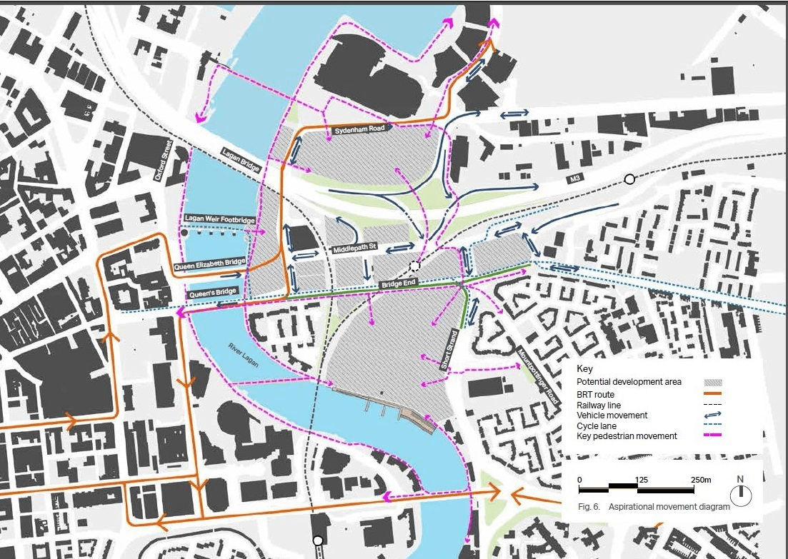
Diagram key
BRT route: solid red line
Railway line: broken black line
Vehicle movement: two navy arrows in opposite directions
Cycle lane: broken blue line
Key pedestrian movement: broken pink line
A framework of connected places
The rationalisation and rebalancing of the movement and access network in the area presents a catalyst for configuring new development over the short, medium and longer terms. Improved public transport, cycle and pedestrian connectivity to, through and within the area will support lower car parking levels within development sites. New residents will be within a short walking distance of city centre attractions and facilities and are likely to include those willing to embrace a new city lifestyle in which car ownership is not essential as other options exist.
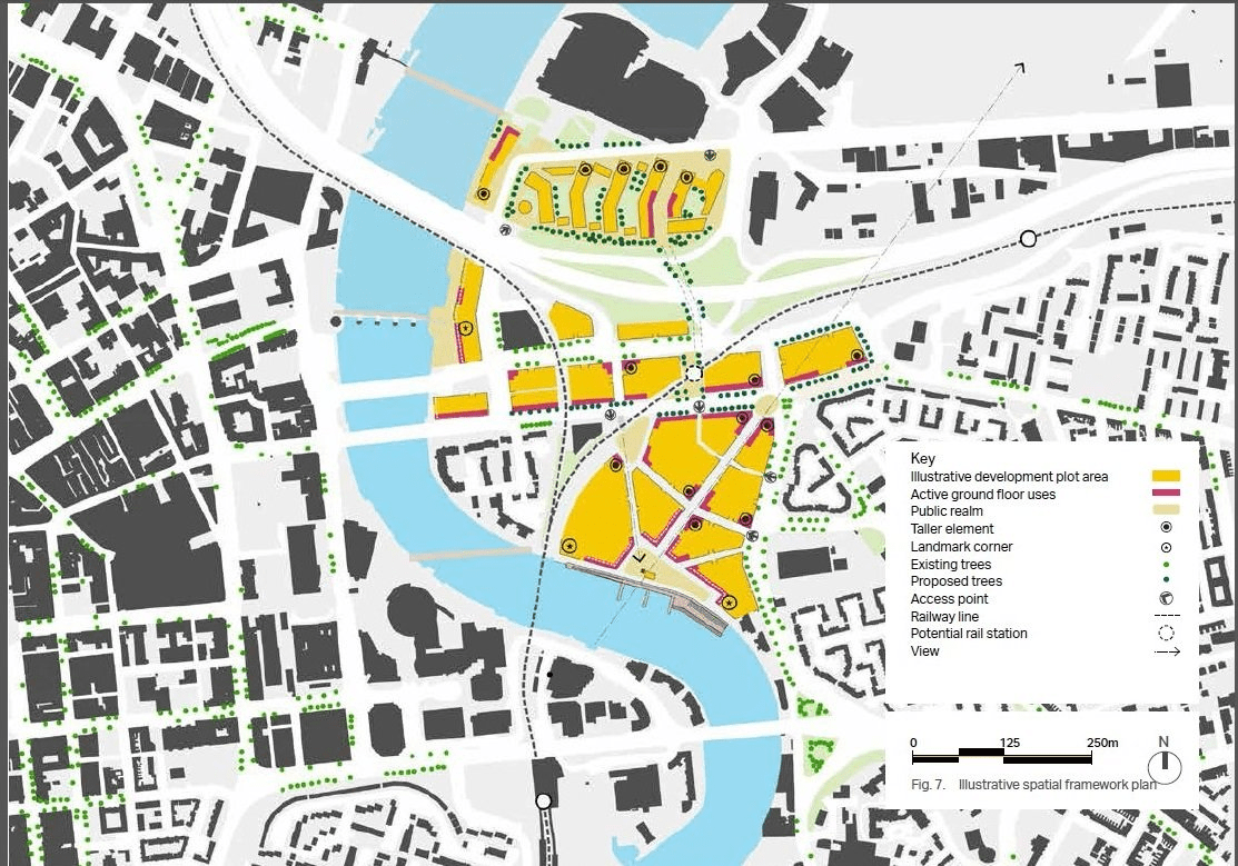
The indicative spatial framework plan shown in Figure 7 is illustrative and demonstrates the extent of development opportunities. It illustrates a conceptual approach to how those development opportunities could be realised. It is anticipated that detailed designs will be brought forward by individual developers for sites. The plan includes those sites with planning permission, those which are currently being planned by private developers and those with development potential but not being considered for development currently.
The plan suggests where key routes (pedestrian, cycle and vehicular), public spaces and street blocks could be located. It is envisaged that the super scale street blocks shown will be further subdivided to create a finer grain of development creating a rich mix of uses and a strong character and identity. The plan shows where frontage development is required to enclose and define streets, walkways and public spaces to establish a coherent urban design structure.
The Sirocco site is pivotal to the regeneration of the area and Figure 7 shows a major public space fronting the river, as highlighted in the City Centre Regeneration and Investment Strategy (CCRIS), and major pedestrian and cycle links. The latter ensure high quality pedestrian links to Short Strand and Bridge End promoting a permeable and outward looking approach to the site.
The plan indicates where active ground floor building uses would be best located. Uses should include restaurants, bars, small convenience and specialist retail, offices, and professional services. Frontage development must also provide overlooking and building entrances. In addition the plan indicates where opportunities exist for landmark buildings and building elements that reinforce street block corners.
The major development sites and areas are:
- Queen’s Quay (Department for Communities progressing)
- Odyssey Quays (planning permission granted)
- Central Spine and adjacent sites (multiple sites)
- Sirocco Quays site (masterplan consultation currently in progress)
Key design principles have been developed for the major sites and are included in Appendix 3.
Figure 7 illustrative spatial framework plan in Belfast East bank
Map key
Illustrative development plot area: solid yellow area
Active ground floor uses: solid red line
Public realm: pale yellow area
Taller element: black circle in white circle
Landmark corner: black dot in white circle
Existing trees: dark green dot
Proposed trees: bright green dot
Access point: arrow in circle
Railway line: broken black line
Potential rail station: broken circle
View: black arrow pointing right
Making it happen
A delivery partnership
The draft East Bank Development Strategy has been developed following extensive consultation and engagement with partners and stakeholders. It is a key move towards implementation of the Special Action Area that has been identified in the Belfast City Centre Regeneration and Investment Strategy.
The strategy focuses on the key moves which will help weave the East Bank into the fabric of the City Centre. These key moves aim to create a lively, diverse, accessible and well connected quarter.
To achieve this ambitions vision for East Bank, the implementation strategy will focus on collaboration, future proofing and forward planning.
Collaboration
There are many key actors required to implement the East Bank Development Strategy. Collaborating with government departments and the private sector is essential to delivering the long-term vision. As a key starting point, there will need to be further engagement with the Department for Infrastructure (DfI) to develop a deliverable plan to consolidate the transport infrastructure. The strategy will be tested with the strategic multi-modal transport mode in the context of the future development of Belfast City Centre as a whole including all currently planned major new developments. The results of the test could be used to confirm the strategy or to optimise and reconfigure elements of the strategy in order to meet objectives shared by Belfast City Council and the Department for Infrastructure as Transport Authority. There will also need to be close dialogue with the Department for Communities (DfC) to ensure that the development brief for Queen’s Quay acknowledges the key principles set out within the East Bank Strategy and that the East Bank complements the plans for East Side Urban Village. Alongside this, there will need to be continued collaboration with DfC to ensure funding for urban regeneration is guided to those projects which have the greatest impact. A land assembly strategy and economic business case appraisal will need to be made to evaluate feasibility of development sites and its contribution to the wider Belfast City Council city-wide agenda.
Collaboration with the private sector to bring forward development which benefits the East Bank will be essential to ensure the best value is achieved.
Future proofing
There will need to be a strong focus on the long-term aspirations. This is crucial when bold moves are required. Short-term gains which are detrimental to the long-term vision should be avoided wherever possible. This will require clear lines of communication between all those involved in the regeneration of East Bank. It would therefore be beneficial to engage with developers through the planning process to ensure an integrated approach to the redevelopment of the area and that the key principles are observed.
Phased implementation
Re-balancing the transport network will require a multi-modal approach to include both incentives and disincentives. In order to make this achievable there must simultaneously be credible provision of public transport, cycling and walking alternatives to the car. This will help soften the impact of rebalancing the road network.
The creation of a park and ride on the edge of the city would be a positive first step and would allow the re-location of the current site, thus providing space for future development. Alongside this the BRT system and improved wider bus network provides incentives for people to use public transport whilst the reduced road capacity will provide a disincentive to driving.
A phased development approach has been taken to establish the implementation of the East Bank Development Strategy.
If appropriate, this will include addressing wastewater treatment capacity in the East Bank via review and phasing of growth.
Short term (2017-2020)
- Traffic Monitoring and data collection of existing cycling and pedestrian movements
- Environmental baseline appraisal including impact of air and noise pollution to residents and vehicle users of the road network
- Preparation of Strategic Environmental Assessment and Habitats Regulation Assessment of the Strategy
- Utilise forthcoming DfI (Rivers) guidance on climate change and impacts on flood risk during design development
- Study and roll-out of uses including pop-up restaurants, small retail offer and exhibitions
- Land assembly study and business case appraisal
- Detailed highway modelling (local access, junction and strategic network consideration)
- Cost-benefit analysis of proposed highway interventions assessment
- Feasibility and Value for Money Assessment of proposal to re-locate rail halt
- Public realm strategy guide-material palette and landscape review
- An animation/meanwhile use strategy to look at short term interventions particularly within public realm and adjacent to the Lagan
- Historic environment and urban landscape review - tall buildings, protection of listed structures and context, and retention of key views
Medium term (2021-2026)
- Review of public transport links, network routing resulting from wider highway proposals such as York Street interchange on implementation of BRT CITI route
- Station Street flyover removal to enable the development of Queen’s Quay site
- Sirocco site bridge link
- Relocation of existing Park and ride facility once an alternative site further east has been evaluated and implemented
Long term (2027-2037)
- A2 Approach flyover removal from the east to create the development of a gateway site
- Rail Halt relocation and development of the ‘shatter zone’ area
- New two-way cycle link along Bridge End
- Two-way bus implementation along Bridge End Boulevard and re-balancing of traffic to Middlepath Street
Forward planning
Belfast City Council is currently progressing the Local Development Plan (LDP) for the city. Following the adoption of the LDP Plan Strategy, the council will be in a position to review the East Bank Development Strategy with a view to bringing it forward as more formal planning guidance. This would provide the East Bank Development Strategy with greater weight in the decision-making process as a more detailed articulation of LDP policy.
The council is currently exploring investment opportunities for Belfast. The UK government is working towards a comprehensive and ambitious set of City Deals to boost investment and help unleash the full potential of Northern Ireland. Belfast along with partner councils is seeking to develop a Belfast City Region Deal (BCRD) with a cohesive programme of investment across infrastructure, innovation and skills.
The council is preparing an infrastructure study to identify the infrastructure priorities to support the growth ambitions of the Belfast Agenda. The priorities identified will contribute to the delivery of the East Bank Development Strategy.
Appendices
Appendix 1
A redefined movement network
The establishment of the Bridge End boulevard concept and the re-balancing of the road network is a long-term vision which will require further detailed modelling on a phased approach to verify what amendments are achievable at that particular timeframe. There are a number of existing highway interventions currently being planning or due to commence shortly and the impact on private vehicle, cyclists and public transport needs to be fully understood before additional measures can be considered.
Over a long-term period the background environmental issues, changing traffic flows, political influence and economic cost of vehicle users, together with adjacent land development needs will be reviewed as this will have a direct impact on the feasibility for phasing of any possible highway interventions.
The phasing shown in the following diagrams are an aspirational phased approach to address the wider East Bank Development Strategy. These are an indicative approach to help deliver the vision for an improved public realm environment and will be subject to review with stakeholders and developers going forward.
Road network in Belfast East Bank
Existing
Diagram 1 illustrates the existing baseline network prior to any committed or proposed changes. As identified previously, East Bank is currently heavily dominated by highway infrastructure which has led to an area which is has relatively poor development potential due to a landscape dominated by the car. Community severance is caused by the large scale infrastructure and facilities for pedestrians, cyclists and public transport users could be significantly improved.
It is also noted that the highway network is known to be relatively constrained in the AM and PM peak hours as a result of congestion, primarily in the westbound and eastbound directions respectively due to the tidal flow of traffic to Belfast city centre.
Diagram 1 Existing transport layout in Belfast East Bank
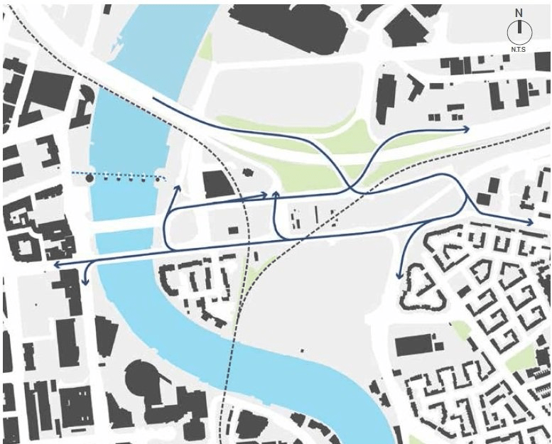
Diagram key
Railway line: broken black line
Existing vehicle access: solid black line
Existing cycle lane: broken blue line
Stage 1 - Cycle path 2017
Implementation of the consented cycle path link by DfI along Middlepath Street.
Diagram 2 reflects the introduction of a two-way cycle lane along the southern edge of Middlepath Street. The cycle lane will occupy one of the current 4 lanes and will provide connectivity to the existing cycle link over the Lagan-Weir Bridge.
An additional toucan crossing point will be required to the east of Queen Elizabeth Bridge and further to the east across Middlepath Street leading towards Titanic Quarter rail halt.
Diagram 2 proposed cycle path in Belfast East Bank
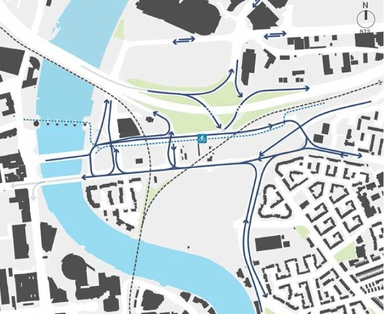
Diagram key
Railway line: broken black line
Existing vehicle access: solid black line
Existing cycle lane: broken blue line
Stage 2 - BRT line 2018-2019
Diagram 3 shows implementation of the CITI route BRT line which will occupy a dedicated vehicle lane in both directions from the city centre to Titanic Quarter.
This route forms an extension to the east-west BRT route and will provide an improved public transport provision utilising a lane over the Queen Elizabeth Bridge and also return across the Queen’s Bridge.
There will be one remaining lane in either direction along Queen’s Quay for non-BRT traffic. A BRT Halt is to be provided outside the SSE Arena.
Diagram 3 Implementation of bus priority route in Belfast East Bank
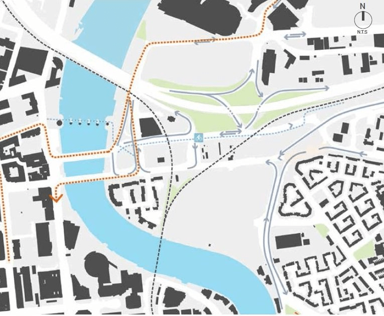
Diagram key
Railway line: broken black line
Existing vehicle access: solid black line
Existing cycle lane: broken blue line
Bus priority route: broken orange line
Stage 3 - Queen’s Quay highway improvements 2021-2026 (indicative timescale)
Diagram 4 shows development of the Odyssey Quays, the development will introduce a new roundabout at the gateway to the development and the Queen’s Quay masterplan will remove the existing Station Street flyover.
The removal of Station Street flyover is required to create development space for the Queen’s Quay site. The road space for BRT and vehicles in and out of Titanic Quarter along Queen’s Quay and Station Street will need to be redesigned and aligned further east, closest to the existing Quay Gate building.
Future pedestrian and cycleway provision could also be considered from Odyssey Quays site across to City Quays development.
Diagram 4 Odyssey Quays development in Belfast East Bank
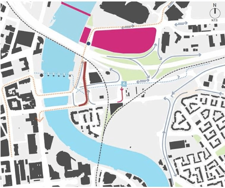
Diagram key
Railway line: broken black line
Existing vehicle access: solid black line
Existing cycle lane:broken blue line
Road closed: solid red line
Existing access removed: thick solid brown line
Anticipated development during phase: thick solid pink line
Stage 4A - City centre gateway creation 2021- 2026 (indicative timescale)
Diagram 5 shows implementation of the Queen’s Quay site the Sirocco and creation of the eastern gateway by removal of the approach flyover from the A2. This stage will also require the relocation of the existing Park and Ride facility once an alternative site further east has been evaluated and implemented.
The removal of the eastern flyover will coincide with a phased change to the 2-way flows along Middlepath Street and development of the sustainable transport corridor along Bridge End.
The southern facing Sirocco site and its Bridgend frontage could be created to improve the public realm along the Lagan alongside the new bridge connection to the city centre and frame the area opposite the central spine sites.
Diagram 5 City centre gateway in Belfast East Bank
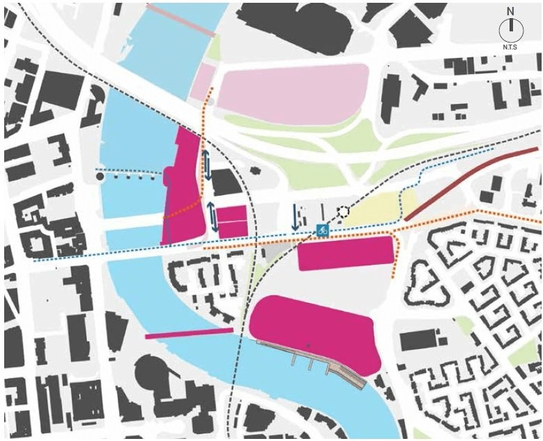
Diagram key
Railway line: broken black line
Existing vehicle access: solid black line
Existing cycle lane: broken blue line
Bus priority route: broken orange line
Existing access removed: thick solid brown line
Park and ride relocated: pale yellow line
Anticipated development during phase: solid pink area
Development completed or under construction: pale pink area
Stage 4B - Bridge End boulevard creation 2027-2037 (indicative timescale)
A long-term aspiration for the East Bank development is the creation of a sustainable transport corridor along Bridge End. Diagram 6 shows new development sites fronting Bridge End would create an active frontage with
a phased re-balancing of the roads to Middlepath Street. Key aspects include:
- rationalising and rebalancing highway infrastructure enabling strategic access but transforming the pedestrian, cycle and public transport experience
- a high-quality public realm, active ground floor building uses
- two-way bus routing along Bridge End
- dominant vehicle movements re-balanced to two-way flow along Middlepath Street
Diagram 6 Bridge End boulevard development in Belfast East Bank
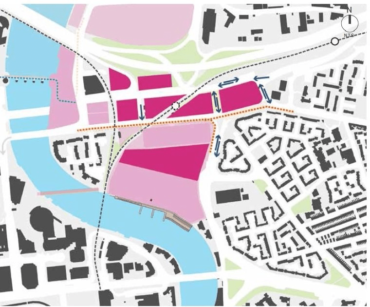
Diagram key
Railway line: broken black line
Existing vehicle access: solid black line
Existing cycle lane: broken blue line
Bus priority route: broken orange line
Existing access removed: thick solid brown line
Park and ride relocated: pale yellow line
Anticipated development during phase: solid pink area
Development completed or under construction: pale pink area
Appendix 2
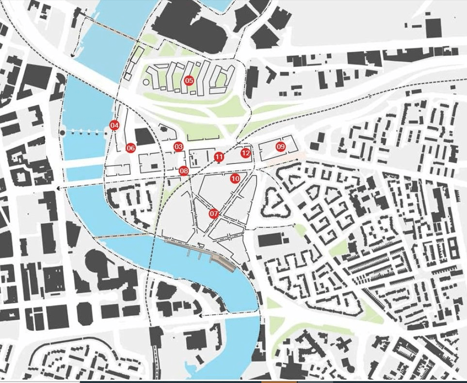
This table should be read along with Key transport projects and movement plan in Figure 15 diagram. These phasing abbreviations are used in the table: 'S' for short; 'M' for medium and 'L' for long.
| Key transport projects and movement projects | Phasing | Delivery | Comments |
|---|---|---|---|
| 1. Integrated multi modal transport modelling, business case and funding bids preparation | S | Belfast City Council Transport NI | Refinement of integrated scenarios and their detailed testing. Selection and development of preferred option, development of business case and funding bids, detailed design of construction phases |
| 2. Introduction of a new car parking standard for all new development in the East Bank area | S | Belfast City Council | In partnership with Transport NI the development and adoption of a new car parking standard as part of the Local Plan Framework |
| 3. Middlepath Cycle path | S | Department for Infrastructure | Implementation of proposed cycle path |
| 4. Bus Rapid Transport Network | S | Department for Infrastructure | Implementation of the BRT network in the area linking SSE Arena, Titanic Visitor Centre and NI Science Park to the city centre |
| 5. Odyssey Quays development | S/M | The Odyssey Trust Company/Odyssey Millennium Ltd | Impact of access to and from 2,700 car parking spaces to be considered in light of additional car parking provision at Queen’s Quay and Sirocco Quays |
| 6. Queen’s Quay development | S/M | Department for Communities/Private development partner | Removal of Station Street flyover |
| 7. Sirocco Quays | S/M | Sirocco Quays development | Improvements to Short Strand and Bridge End including contributions to the realisation of Boulevard concept, improved pedestrian crossings to Short Strand community area |
| 8. Bridge End/Middlepath Street/Dalton Street | M/L | Department for Infrastructure Transport NI (TNI) |
Implementation of new road hierarchy and allocation of road space, removal of A2 flyover, introduction of two way routing, enhanced bus access and improved pedestrian and cycle environment subject to 1 |
| 9. Rationalisation of A2 flyover | M/L | Department for Infrastructure Transport NI |
In partnership with Belfast City Council, DfI and TNI. Subject to 1 |
| 10. North-south pedestrian link | M/L | Department for Infrastructure Transport NI |
In partnership with Belfast City Council, DfI and TNI. Subject to 1 |
| 11. Relocation of Titanic Rail Station | M/L |
|
In partnership with Belfast City Council, DfI and TNI. Subject to 1 |
| 12. Relocation of Eastside Park and Ride site | M | Transport NI | Closure of the existing car park creating a development site and the re-provision of car parking in an outer location |
Figure 15 diagram Key transport projects and movements plan in Belfast East Bank
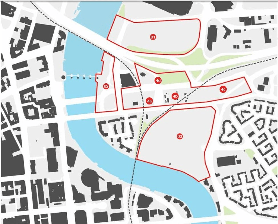
This table should be read along with Key development sites plan in Figure 16 diagram. These phasing abbreviations are used in the table: 'S' for short;' 'M for medium and 'L' for long.
| Key development site project | Phasing | Delivery | Comments |
|---|---|---|---|
| 1. Odyssey Quays | S/M | The Odyssey Trust Company/Odyssey Millennium | Area: 6.9 hectares, 17 acres Height: 5 to 29 storeys Size: 158,000 sqm, 1.7m sqft Uses: apartments, hotels, retail, offices, cafés, bars, restaurants, community uses, car parking (2,700 spaces) Planning approval granted |
| 2. Queen’s Quay | S/M | Department for Communities/Private development partner | Area: 1.3 hectares, 3.2 acres Uses: mix to be determined Removal of Station Street flyover and Handy Park surface car park facilitates a larger development site opportunity Viability testing ongoing |
| 3. Sirocco Quays | S/M | Swinford (Sirocco) Ltd (part owned by St Francis Group) | Area: 6.5 hectares, 16 acres Uses: offices, housing, hotel, apartment hotel, restaurant, café, local retail, multi-storey car park, new pedestrian bridge across the River Lagan Current scheme subject of public and stakeholder consultation during 2018 |
| 4. Central Spine sites | S/M | Belfast City Council private developers |
Multiple sites requiring land assembly Potential for significant development density and creation of enclosing building frontages |
| (a) Station Street to Dalton Street (West) | S/M | Belfast City Council private developers |
Requires removal of Queen’s Bridge (East) Handy Park surface car park, adjacent surface car park and rationalisation of Dalton Street |
| (b) Dalton Street (East) to elevated railway line | M/L | Belfast City Council private developers |
Requires land assembly of existing employment space |
| (c) Elevated Railway Line to Middlepath Street/Newtownards Road | M/L | Belfast City Council private developers |
Requires land assembly, removal of M3 off ramp, removal of park and ride site and new rationalised road layout. Inclusion of existing petrol filling station subject to feasibility |
| (d) Scrabo Street/Middlepath Street (North) | M/L | Belfast City Council private developers |
Land assembly and rationalisation of M3 slip road required |
Figure 16 diagram Key development sites plan for Belfast East Bank
This table should be read along with key public realm projects plan in Figure 17 diagram. These phasing abbreviations are used in the table: 'S' for short; 'M' for medium and 'L' for long.
| Key public realm project | Phasing | Delivery | Comments |
|---|---|---|---|
| 1 East Bank Public Realm design guide and manual | S | Belfast City Council | The guide will ensure the co-ordinated design of the public realm identifying key design principles and parameters, street furniture and materials palette, temporary, event and pop up uses, public art and lighting, management and maintenance, procurement |
| 2 Lagan River front Pedestrian Walkway | S/M/L | Belfast City Council | The co-ordinated design and delivery of the Lagan Loop concept |
| Section a - SSE to Queen’s Bridge | S/M | Odyssey Quays and Queen’s Quays developments | The potential for temporary and pop up uses to draw visitors into the area should be considered at an early stage. Queen’s Quay to deliver major facelift and improvement of existing walkway spaces |
| Section b - Queen’s Bridge to Lagan Viaduct | S/M | Belfast City Council | Upgrade of existing walkway |
| Section c - Lagan Viaduct to Albert Bridge | S/M | Sirocco Quays development | To include new footbridge linking Sirocco Quays to Lanyon Quay and Belfast Waterfront, River front Plaza and new extended board walk, piers, pontoons and moorings |
| 3 Odyssey Quays Plaza | S/M | Odyssey Quays development | Explore opportunities for alignment with the East Bank Strategy at an early stage |
| 4 Sirocco Quays | Sirocco Quays development | Major public realm improvements are required of this development | |
| (a) River front Plaza | S/M | Sirocco Quays development | River front plaza design to fully integrate with transformed river front walkway spaces including extended board walk, view points, piers, pontoons, moorings |
| (b) Internal spaces for example Bridge End Square, public courtyards |
M | Sirocco Quays development | The Spatial Framework Plan promotes a network of connected courtyard spaces within major street blocks and the creation of a space facilitating access to the relocated rail station and into the site. |
| (c) Key internal streets | M | Sirocco Quays development | To include a clear a hierarchy of streets, paths and walkways |
| (d) Key external streets interface - Short Strand, Bridge End | M | Sirocco Quays development | The scheme must contribute to the creation of a consistent building line and frontage along Bridge End and Short Strand and the realisation of the Bridge End Boulevard concept. |
| 5 Key mixed use streets | M | Transport NI | n partnership with Translink, TNI and Belfast City Council |
| (a) Station Street | M | Transport NI | Linked to the delivery of Bus Rapid Transit and the Queen’s Quay development |
| (b) Sydenham Street | M | Transport NI | Linked to the Odyssey Quays development |
| (c) Middlepath Street | M/L | Transport NI | Feasibility study/traffic modelling required short term to determine possible interventions. Financial contributions from frontage sites required. |
| (d) Bridge End | M/L | Sirocco development | Key bus, cycle and walking route, Boulevard Concept to be further developed. Financial contributions from frontage sites required |
| (e) Short Strand | M/L | Sirocco development | Improved pedestrian crossings to be included. |
Figure 17 diagram Key public realm projects plan for Belfast East Bank
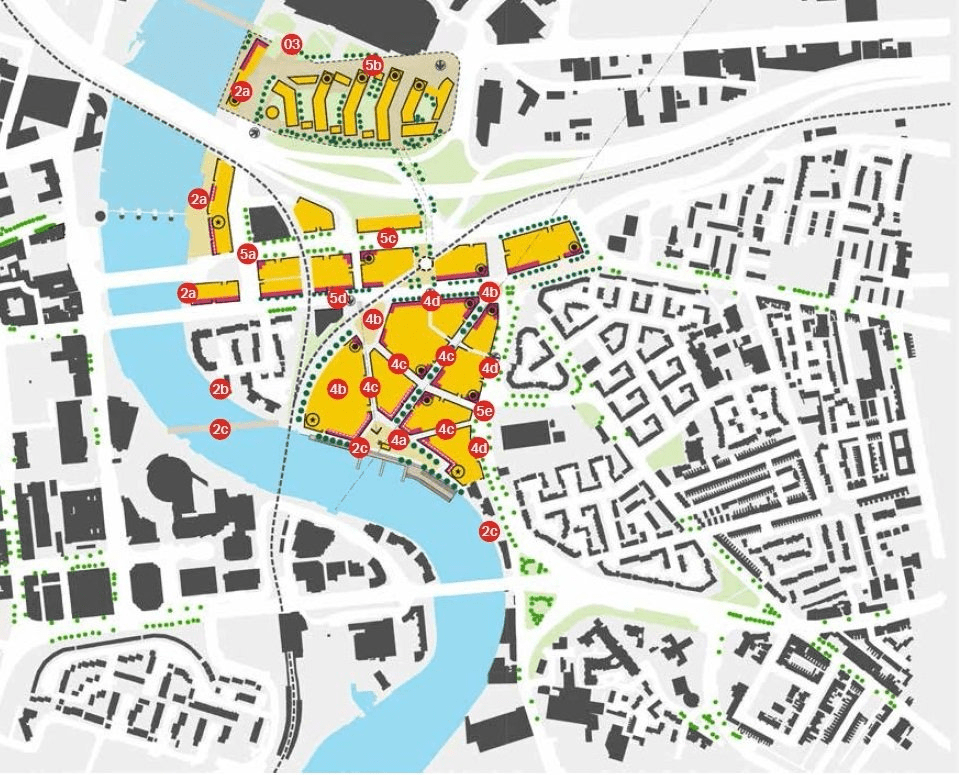
Diagram key
Proposed development: solid yellow
Public realm: pale yellow
Existing trees: dark green circle
Proposed trees: light green circle
Railway line: broken black line
Potential rail station: broken black circle
Appendix 3
Sirocco site
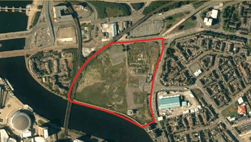
A 6.5 hectare (16 acre) former industrial site located at Short Strand and adjacent to Bridge End and the River Lagan.
The high quality mixed use redevelopment of this site supporting the objectives and principles of the East Bank Development Strategy is essential if the regeneration of the area as a whole is to deliver the maximum social, environmental and economic benefits.
Proposals which are inward-looking or poorly connected, which do not fully address the potential of the riverfront should not be supported. Development on the site should create continuity of street frontages, a quality public realm and a mix of activity during the day and into the night.
Key design principles
All development proposals for this site should respond to the following key principles:
- Ensure a coherent street and building block structure that creates and defines key pedestrian routes, mixed use streets and public spaces to include a clear definition of public and private space. Large street blocks should be subdivided to create a finer grain of development permeated by pedestrian routes and punctuated by public spaces
- Buildings must provide active frontage to Short Strand and Bridge End and contribute to the achievement of a quality streetscape in both locations including, but not limited to, street tree planting, footway widening, street furniture and lighting and new and improved pedestrian crossings
- Ensure that new buildings create continuity of built frontage to all streets, spaces and pedestrian paths. Unnecessary setbacks are to be avoided unless enhancing the public realm. Frontages are to incorporate main entrances and facilitate overlooking from upper floors. New development should also create active ground floor uses that interact with the street including cafés, bars, restaurants, convenience and specialist retail
- It is envisaged that new frontage buildings will generally be between five and 10 storeys in height. Subject to a coherent design rational the opportunity exists for a limited number of taller building blocks in excess of 10 storeys. In addition potential exists to highlight building corners or building elements that feature in key views via a selective increase in building height. Arcaded building frontages should be included on the river front and along primary pedestrian routes
- The objective is to achieve a unity of building frontage design and avoid monotonous uniformity of height, elevation design, materials treatments and rooflines. This will create visual interest and rhythm in the street scene and help to create a world class riverfront
- Public space should be the subject of a co-ordinated design approach that incorporates significant areas of planting including street trees and sustainable drainage systems, creates flexible green spaces that are able to host a range of activities during the day and into the evening, integrate public art and creative lighting
- The layout of individual sites should include high quality external amenity spaces, parking (car and cycle) and servicing spaces (including waste storage and recycling areas) to support mixed uses, in particular residential development
Sirocco site
Queen’s Quay
A 1.3 hectare (3.2 acre) site promoted by the Department for Communities.
Queen’s Quay represents a major opportunity to both reconfigure the highway network via the removal of the Station Street flyover within the vicinity of the site and deliver a major riverfront mixed use development.
Contributing to the quality, coherence and activation of the Lagan Loop pedestrian walkway at this location will be a critical factor in the success of any scheme that comes forward.
Uncoordinated, overbearing and overscaled development will have a negative impact on the city’s riverfront albeit that higher density development and outstanding architectural design will enhance the aesthetic impact, encourage wider regeneration and city centre living.
All development proposals for this site should respond to the following key principles:
- Ensure that new buildings create continuity of built frontage to the River Walkway and adjacent streets. Unnecessary setbacks are to be avoided unless enhancing the public realm. Frontages are to incorporate main entrances and facilitate overlooking from upper floors. New development should include active ground floor uses that interact with the walkway and streets including cafés, bars, restaurants
- New frontage buildings will generally be between 6 and 10 storeys in height. Subject to a coherent design rational the opportunity exists to consider taller building blocks and to highlight building corners or building elements that feature in key views via a selective increase in building height.
- It is envisaged that this prominent riverside site will be composed of a mix of land uses including offices, residential, possible hotel use, and bars, cafés and restaurants at ground floor
- The riverside walkway must be significantly enhanced by any new development. Overbearing development that compromises the usability and attractiveness of the walkway should be rejected
- Consideration should be given to ground floor arcades being incorporated into the riverfront elevations to enhance the walkway, and provide weather protection for spill out ground floor uses such as cafés
- The objective is to achieve a unity of building frontage design and avoid monotonous uniformity of height, elevation design, materials treatments and rooflines. This will create visual interest and rhythm in the street scene and contribute positively to the riverfront. Green space is also encouraged
This extensive and high density mixed use scheme is the first of the major development sites to secure planning permission. Its implementation will be a considerable boost to investor confidence in East Bank if delivered and to the right level of quality. The density and scale of development is considerable and includes a 29-storey tower component on the riverfront.
The proposal for the site includes residential apartments, two hotels, cafés, bars and restaurants, retail, community uses, offices, public realm improvements and car parking.
The scheme predates the East Bank Development Strategy. However, the opportunity should be taken to reassess the integration with the rest of the area in light of the strategy should the circumstances arise or via a proactive development management approach seeking to shape the area in a manner that delivers wider benefits.
Queen's Quay
Odyssey Masterplan
Developer: Odyssey Trust Company
Architect: Henry J Lyons Architects
Scheme refinement
The proposed north south pedestrian link from Sirocco river plaza to the Titanic Quarter may, subject to detailed modelling, require the rationalisation of the M3 slip roads adjacent to Odyssey Quays. This could suggest the better integration of the proposed development and the link to mutual benefit. It is noted that this part of the scheme is seen as a later phase of delivery. In addition should the opportunity arise the impact of the development on the Lagan Riverfront public realm should be reconsidered.
Aerial perspective of the proposed scheme along Sydenham Road to the proposed 29 storey tower adjacent to M3 Motorway Bridge
Aerial perspective of the proposed scheme from the south east illustrating the height, scale and massing of proposed blocks in relation to the SSE Arena
Revised sketch of the proposed tower and block fronting the River Lagan
Central spine sites
Site area: 5.7 Hectares (14 acres) approximately
The central spine is composed of a number of sites in private and public sector ownership. The overall objective is to secure the mixed use redevelopment of sites, creating a coherent urban structure characterised by continuity of new building frontages and bringing activity along all streets.
The proposed rationalisation of the highway network and the relocation or decommissioning of surface car parks will provide an additional impetus for change in this part of East Bank. Subject to feasibility study and business case development it is proposed to relocate the Titanic Quarter rail halt to the central spine. This would support development density and further reduce the need for car parking and vehicular access potentially exacerbating traffic congestion in the area. Land assembly may be required to support the delivery of development and the realisation of the Bridge End boulevard concept.
Key design principles
All development proposals in the area should respond to the following key principles:
- Ensure that new building create continuity of built frontage to all streets. Unnecessary setbacks are to be avoided. Frontages are to incorporate main entrances and facilitate overlooking from upper floors. New development should also create active ground floor uses that interact with the street including cafés, bars, restaurants, convenience and specialist retail.
- It is envisaged that new frontage buildings will generally be between 6 and 8 storeys in height. Additional storeys of up to 12 floors will need to be set back from the main frontage. Subject to a coherent design rationale the opportunity exists to highlight building corners or building elements that feature in key views via a selective increase in building height.
- The proposed relocation of the Titanic Halt railway station to the central spine will increase public transport accessibility and suggests that development density should respond to this factor.
- The objective is to achieve a unity of building frontage design and avoid monotonous uniformity of height, elevation design, materials treatments and rooflines. This will create visual interest and rhythm in the street scene. Green open space is also of key importance to these sites.
- It is envisaged that pedestrian routes will be required to and from the proposed relocated rail station to Middlepath Street and Bridge End and that public spaces will be required to facilitate access, to provide an appropriate setting and increase visual linkages from adjacent streets.
- The layout of individual sites should include high quality external amenity spaces, parking (car and cycle) and servicing spaces (including waste storage and recycling areas) to support mixed uses in particular residential development. All proposals should indicate a clear definition between public and private space. Where a significant scale of development is proposed consideration should be given to the provision of a car club electric/hybrid vehicles for residents use.
- It is envisaged that the central spine will be composed of a mix of land uses including:
- offices
- residential
- bars/cafés/restaurants (ground floor)
- convenience and specialist retail (small scale, ground floor)
Development site in Odyssey Masterplan
