Prepared by AECOM on behalf of the applicant Belfast City Council
September 2022
Table of contents
1. Introduction
- 1.1 Background
- 1.2 Purpose of Report
3. Qualitative responses and consideration
4. Conclusion
1. Introduction
1.1 Background
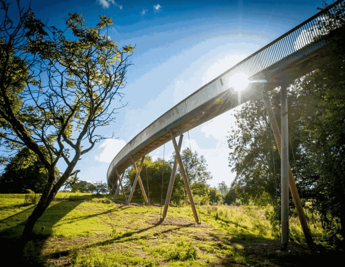
AECOM acting on behalf of our client, Belfast City Council (BCC), is applying to the Planning Department at BCC for planning permission to undertake environmental improvement works (hereafter referred to as “the proposed development”) for Phase 2 of the Lagan Gateway project in South Belfast. The proposed development will build on the success of Phase 1, which included a new pedestrian and cycle bridge, connecting Stranmillis to Annadale. Phase 2 will see the development of a greenway connection from Lagan Lands East at Annadale through to Belvoir Forest Park, to further encourage and enable more sustainable travel. The proposed development is summarised as follows:
- Proposal: Lagan Gateway Phase 2 - environmental improvement works to create a shared walking/cycling connection between Phase 1, Annandale Embankment, Hampton Park, Galwally Avenue and Belvoir Park Forest. To incorporate widening and re-surfacing works to existing informal paths providing new 3m and 4m wide asphalt paths, new 3m wide compacted gravel path and new 2m wide mown grass path; new 3m wide raised timber boardwalk (approximately 84m long); new bollards and associated vegetation removal/planting.
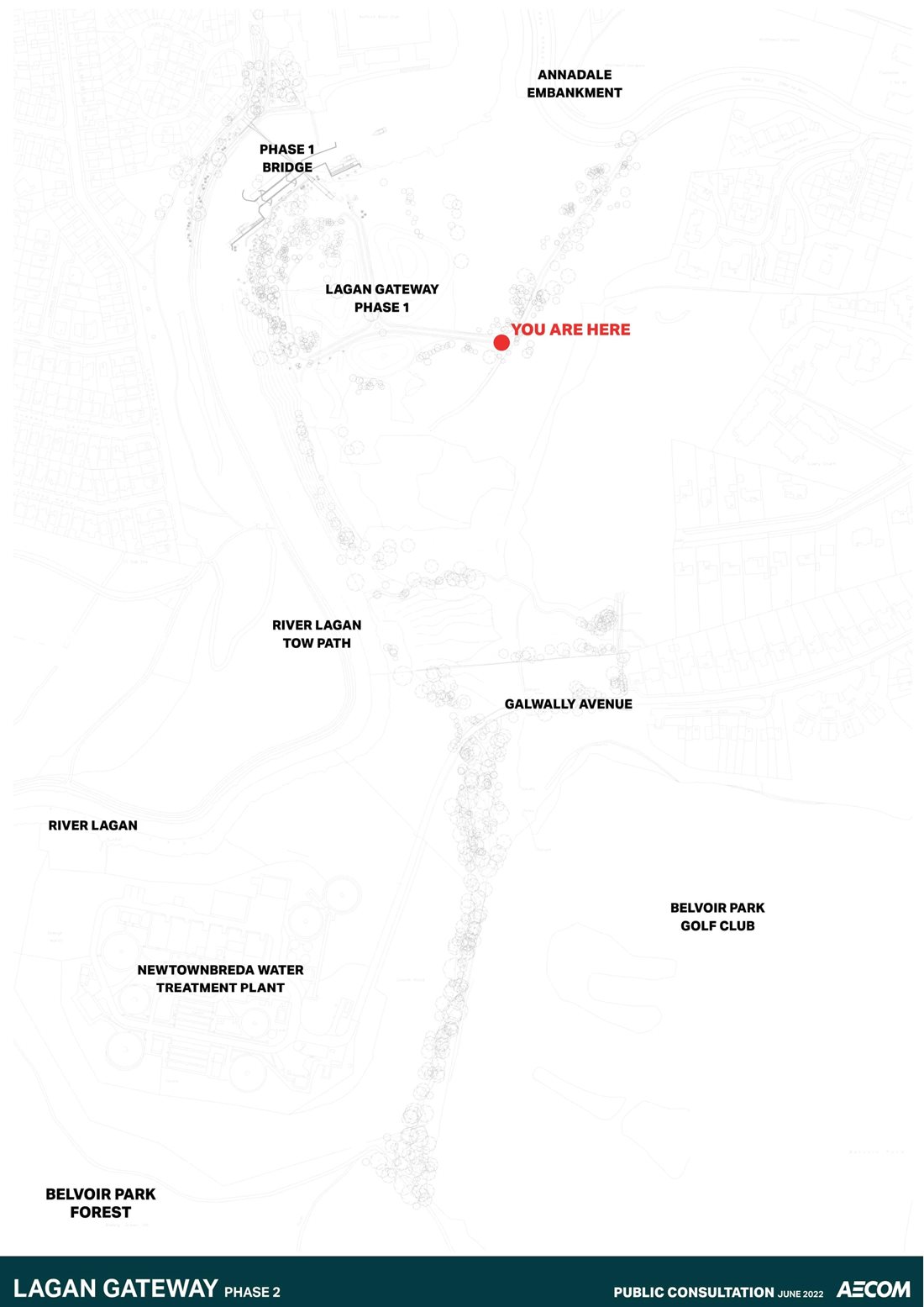
- Address: Lands to the east of the River Lagan located between Lagan Gateway Phase 1 and Belvoir Park Forest, crossing at Galwally Avenue, running adjacent to Belvoir Park Golf Club and Newtownbreda Water Treatment Plant, Belfast.
1.2 Purpose of Report
The purpose of this report is to outline the consultation process which has been undertaken in relation to the proposed development, providing a summary and analysis of the comments collected during the consultation, demonstrating how the views of the consultees have been considered where applicable. It is hoped this report will address the community issues raised during the consultation, providing for smoother and more effective decision-making process.
Section 27 of the Planning Act (Northern Ireland) 2011 places a statutory duty on applicants for planning permission to consult the community in advance of submitting an application, if the development falls within the major category as prescribed in the Planning (Development Management) Regulations (Northern Ireland) 2015 (see relevant extract replicated in Table 1). Developments which meet or exceed the criteria set out in column 2 are considered major development, in relation to this table the proposed development is considered in to fall within Category 9 - All other development.
Table 1
| Description of Development | Major Developments Threshold or Criteria |
|---|---|
|
9. All other development. Any development not falling wholly within any single class of development described in Parts 1 to 8 above. |
a) development that comprises 5,000 square metres or more gross floor space; or b) the area of the site is or exceeds 1 hectare. |
The proposed development has a site area under 1ha and does not include development that comprises 5,000 square metres or more gross floor space. Therefore, the proposed development doesn’t constitute major development, as such there is no statutory requirement to undertake community consultation. However, as the proposed development is part of a wider programme of important developments in the area, the applicant thought it was necessary to consult with the community prior to the submission of the planning application. By undertaking consultation, the applicant has sought to raise awareness of the proposals whilst also gathering initial feedback to inform the emerging designs.
2. Consultation responses
2.1 Introduction
This chapter provides a summary of the views expressed by those who responded to the consultation process. The consultation material (see Appendix A) was hosted online between 5 June 2022 and 4 July 2022 on BCC’s consultation portal [1]. An online survey including 16 questions was provided to allow the public to submit their views. In addition to this, an in-person information event took place on site on 18 June 2022, at Lagan Land East were members of the project team were present between 10am and 2pm to discuss the proposals.
2.2 Summary of Public Engagement
In total, 322 individual surveys were returned by the public. At the end of the consultation the survey responses were collated and analysed. This involved both a numerical analysis of the quantitative data and a thematic analysis of the qualitative data collected from the open-ended questions.
The following section includes graphs and charts which visualise the collated results of the close-ended questions from the survey. Note, Questions 7 and 8 of the survey were open ended and the results of these are detailed within the following chapter. Questions 9 to 16 have been excluded from the analysis as these don’t directly relate to the proposed development, instead these questions largely relate to BCC’s Section 75 [2] equality duties.
2.2.1 Quantitative Data from Survey
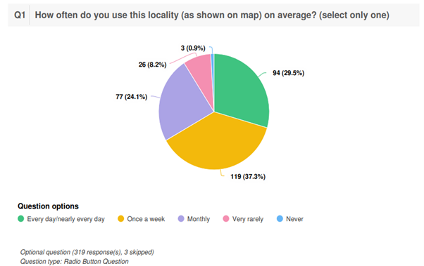
Question 1
How often do you use locality on average?
Question 1 asked respondents to indicate how often they use the proposed development’s locality. As shown in Figure 2-1, “Once a week” was the most popular response at 37.8 per cent, followed by “every day/nearly every day” at 29.5 per cent and “monthly” at 24.1 per cent. “Very rarely” and “Never” received much lower levels of response at 8.2 per cent and 0.9 per cent respectively.
Figure 2-1: Question 1 Response Summary
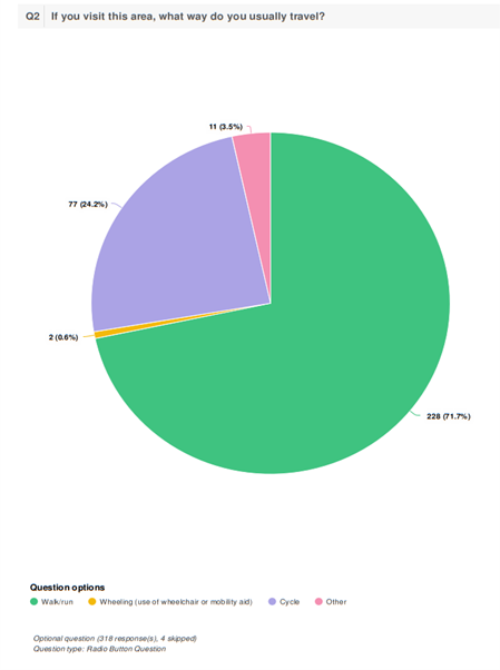
Question 2
If you visit this area, what way do you usually travel?
Question 2 asked respondents how they usually travel to the area. Figure 2-2 shows that the majority of respondents (71.1 per cent) “walk/run” to the area. A smaller proportion (24.2 per cent) visit the area by “cycle”, whilst 0.6 per cent visit the site “wheeling” using a wheelchair or other mobility aid.
Figure 2-2: Question 2 Response Summary
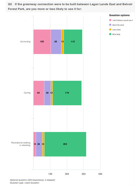
Question 3
If the greenway connection were to be built between Lagan Lands East and Belvoir Forest Park, are you more or less likely to use it for:
Question 3 asked respondents to rank how likely they were to us the proposed connection for commuting, cycling and recreational use. From the results 252 respondents stated that they were likely to use the greenway for recreational usage, with commuting being the least popular, with 103 respondents stating they don’t believe they would use it for commuting purposes.
Figure 2-3: Question 3 Response Summary
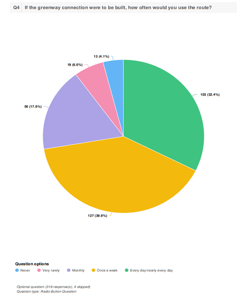
Question 4
If the greenway connection were to be built, how often would you use the route?
Question 4 asked respondents how often they would use the proposed route. Figure 2-4 shows that “Once a week” was the most popular response at 39.9 per cent, followed closely by “Every day/nearly every day” at 32.4 per cent, both representing higher proportions than the same responses in relation to existing usage (see Question 1). The next most popular response was “Monthly” at 17.6 per cent. “Very rarely” and “Never” received much lower levels of response at 6.0 per cent and 4.1 per cent respectively.
Figure 2-4: Question 4 Response Summary
Question 5
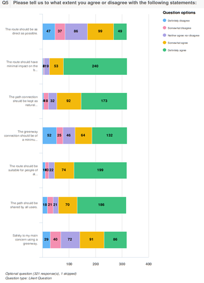
Tell us to what extent you agree or disagree with the following statements:
Question 5 asked respondents to what extent did they agreed or disagreed with the following statements:
- The route should be as direct as possible.
- The route should have minimal impact on the biodiversity.
- The path connection should be kept as natural as possible and follow the existing informal route.
- The greenway connection should be of a minimum of 4 m so that it meets the standards set out for national cycling.
- The route should be suitable for people of all abilities.
- The path should be shared by all users.
- Safety is my main concern using a greenway.
Figure 2-5 shows the results of this question. The strongest level of agreement across the seven statements (combining definitely agree to somewhat agree) was for “The route should have minimal impact on the biodiversity”.
The next greatest level of agreement came for “The route should be suitable for people of all abilities”, followed by “The path connection should be kept as natural as possible and follow the existing informal route” and “The path should be shared by all users”.
It is clear the respondents were most divided on the following statements: “The route should be as direct as possible”, “The greenway connection should be of a minimum of 4 m so that it meets the standards set out for national cycling” and “Safety is my main concern using a greenway”.
Figure 2-5: Question 5 Response Summary
Question 6
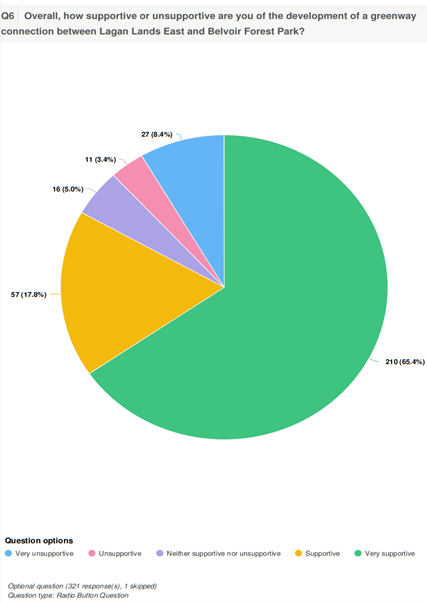
Overall, how supportive or unsupportive are you of the development of a greenway connection between Lagan Lands East and Belvoir Forest Park?
Question 6 asked respondents how supportive they were of the development of a greenway connection between Lagan Lands East and Belvoir Forest Park. As shown in Figure 2-6, the vast majority (83.2 per cent) of respondents were either “supportive” or “very supportive” of the proposed development. Conversely, only 11.8 per cent of respondents were either “unsupportive” or “very unsupportive”, whilst 5.0 per cent were “neither supportive nor unsupportive”.
Figure 2-6: Question 6 Response Summary
- [1] https://yoursay.belfastcity.gov.uk/lagan-gateway-phase-2
- [2] Section 75 of the Northern Ireland Act 1998. This places a statutory obligation on Public Authorities to carry out their functions with due regard to the need to promote equality of opportunity and good relations
3. Qualitative responses and consideration
3.1 Introduction
This chapter explores the main themes raised during the consultation process, providing a response to each of issues and detailing, where appropriate, how the proposals could be amended. Questions 7 and 8 within the questionnaire were open ended and allowed respondents to express their opinions, recommendations and concerns on the scheme. The questions asked:
- Question 7: Do you have any comments about the proposed greenway connection?
- Question 8: Is there anything else you might want to see supplementing the greenway?
3.2 Feedback and applicants’ response
It is recognised that a number of concerns were identified during this consultation process. Table 2 and Table 3 provides a summary of the themes raised.
Table 2
| Theme | Summary of concern | Applicant’s Response |
|---|---|---|
| Tree removal | Trees should not be cut down for the proposed development. |
Site investigation works were planned to be undertaken at Lagan Lands East to inform the final designs for proposed development. This required the removal of a small area of hedgerow, in order to enable these essential works to be carried out. These works were developed with a certified ecologist, and inspections undertaken, in accordance with the relevant legislation, to ensure there were no active nests within the small area of hedgerow which was removed. The proposed route has been chosen as it largely formalises existing informal paths and desire lines, reducing potential extent of tree clearance. |
| Trees and hedges need permission to be cut down. |
Consent is not required to carry out works to unprotected trees/hedges. Any works required to trees with TPO status will require an “application for tree works” to be completed and approved in advance of any works. |
|
| Query if felled trees would be replanted? | Yes, felled trees will be replaced where appropriate to ensure the character of the site is retained. Advice from landscape planners and biodiversity officers will be sought as required. | |
| Tree removal should not have taken place in the middle of nesting season. |
As noted above the removal of a small area of hedgerow has been required to enable essential site investigation works to be carried out. These works were developed with a certified ecologist, and inspections undertaken, in accordance with the relevant legislation, to ensure there were no active nests within the small area of hedgerow which was removed. |
|
| Environmental concerns | The proposals should have minimal impact on biodiversity and ecology. |
As part of the pre-application discussion (PAD) process Northern Ireland Environment Agency (NIEA) have been consulted and liaised with on the proposals. Ecological surveys have also been undertaken to inform the design and construction methods. The proposed route has been chosen as it largely formalises existing informal paths and desire lines, reducing potential extent of tree clearance. The planning application will be supported by a Construction and Environmental Management Plan (CEMP) detailing management measures to minimise environmental impact from the construction phase. |
| How can the potential biodiversity loss be justified? |
As noted above, ecological surveys have been undertaken to inform the design and construction methods. The proposed route has been chosen as it largely formalises existing informal paths and desire lines, reducing potential extent of tree clearance. The proposed development will bring many benefits, building on the success of Phase 1. The new greenway will connect Lagan Lands East to Belvoir Forest Park, as part of the Department for Infrastructure’s Belfast Cycling Network. It’s anticipated that this will ease the pressure on the existing towpath on the Stranmillis side; currently the towpath is used extensively by walkers, cyclists, commuters, dog walkers, families with children. It is envisaged that the new route will be mainly used by cyclists and pedestrians looking for a different experience. |
|
| Query if there is another route which would reduce the environmental impact of the proposed development? | A number of design options were considered prior to this consultation. The option which was consulted on largely formalises existing informal paths and desire lines, reducing potential extent of tree clearance. | |
| Query if an Environmental Impact Assessment (EIA) would be undertaken? | In line with relevant legislation BCC Planning Department will be required to make an EIA Screening Determination. An Environmental Statement will be required should it be concluded that the proposed development constitutes EIA development. | |
| Will natural surfaces be used, to limit the use of manmade materials? | All surface materials will be considered through the design process. Natural materials would be preferable to retain the natural character of the site but will require the necessary approvals from DFI (Funders) and BCC maintenance departments. | |
| How will the increase in noise level impact wildlife? |
A Construction and Environmental Management Plan (CEMP) will be prepared and issued to NIEA, detailing mitigation measures to reduce impacts associated with noise and vibration during the construction phase. The impact of user generated noise on wildlife hasn’t been raised as a concern by NIEA as part of initial consultations. |
|
| Query if rewilding would take place? | This will be considered through the design process but subject to approvals from landowners/funders and BCC maintenance departments. | |
| Design and safety | Query if signs would be erected to direct users? | As with the existing towpath arrangement, wayfinding/directional signage will be installed to direct users along the proposed route. |
| Query if segregated cycle lanes would be possible? | No delineation is proposed to separate cyclists from pedestrians along the route to tie in with the Lagan Tow Path and paths within Belvoir Forest. Segregation could have a bigger impact on the surrounding environment as the footprint of the path would be wider. | |
| Query if the proposed private development on Hampton Park could include through-access for pedestrians and cyclists? | A private developer is currently undertaking construction works for a residential development at Hampton Park. The plans associated with this private scheme suggest a connection will be provided between the residential development and the Lagan Lands East area. | |
| What safety features there would be for pedestrians against high-speed cyclists? | Where possible the proposed path has been widened, allowing users to pull-in/pass-by. It’s unlikely that cyclists will be traveling at high speeds along the route as there are no clear straight runs. Breaks along the route including Galwally Avenue and the boardwalk) will encourage cyclists to slow down. |
|
| Query if bitmac could be used for paving? | This will be considered through the design process but the preference currently is for a more natural material e.g. crushed stone/quarry dust but will be subject to approvals from DFI (Funders) and BCC maintenance departments. | |
| Query if access gates could be removed as they restrict access for wheelchairs/bikes/prams? | Where appropriate gates will be removed to improve access for all. Existing kissing/gate adjacent to golf club is proposed to be removed. | |
| Antisocial behaviour issues | How antisocial behaviour would be limited in this area? | With the expected increase in footfall along this route it is expected that this “passive surveillance” will be enough to limit the anti-social. Based on previous experience on similar projects this has proven to be very successful at mitigating anti-social behaviour. |
| Query if CCTV be provided? | There is currently no CCTV planned for this scheme. | |
| How can graffiti be limited in this area? | With the expected increase in footfall along this route it is expected that this “passive surveillance” will be enough to limit the graffiti in the area. In addition, there is limited surfacing proposed within phase 2 that graffiti could be placed on. | |
| Accessibility | What is being done to ensure that all wheels (abilities) can use the development? | The proposed route will be designed to be at least 1:21 and therefore DDA compliant and accessible for all. In addition, surfacing will be designed to be robust enough to cater for all wheeled access. |
| Consultation | Query if there would be public involvement on the route options and a face-to-face meeting with BCC? | is considered that the issues raised in consultation have been adequately addressed and one feasible route currently exists. There will be opportunity to make formal representations regarding the proposed development at the planning application stage when normal neighbourhood notification and publicity will be undertaken. |
| Maintenance | Query if more bins would be provided? | Yes, additional bins will be located along the route. |
| Who would be responsible for the maintenance of the pathways and wider area? | BCC City and Neighbourhoods will be responsible for maintenance for the extents of the proposed development. This will be subject to agreements with the various landowners. |
Table 3
| Theme | Summary of Concern | Applicant’s Response |
|---|---|---|
| Dedicated lanes | Query if there could be dedicated cycle lanes? | No delineation is proposed to separate cyclists from pedestrians along the route. |
| Lighting | Will there be lighting along the path? | There is currently no lighting planned for this scheme. |
| Query if low level LED lighting could be used to reduce light pollution? | There is currently no lighting planned for this scheme. | |
| Seating and picnic areas | Query if seating would be supplied? | These will be considered as part of the proposed scheme. |
| Query if picnic and public spaces would be provided? | These will be considered as part of the proposed scheme. | |
| Design/location | Could an alternative route for cyclists only be considered? | Whilst the proposed greenway will be part of the Department for Infrastructure’s Belfast Cycling Network, there are no plans for a cycle only route at this location. The proposed development will seek to promote all forms of active travel including walking, wheeling and cycling |
| What measures will be put in place to limit parking in the surrounding area? | Car parking in the surrounding area will continue to be managed and enforced in line with current arrangements. Issues in regard to public roads and car parks should be a raised matter with DfI Roads. | |
| Will speed ramps be put in place to limit cyclists speed? |
No speed ramps are proposed along the route as these have potential to restrict access to other wheeled users (i.e. pram, mobility scooter and wheelchairs. It’s unlikely that cyclists will be traveling at high speeds along the route as there are no clear straight runs. Breaks along the route (including Galwally Avenue and the boardwalk) will encourage cyclists to slow down. |
|
| Signage and awareness | Will signs be erected to show the route/trails of the greenway, allowing users to understand how the shared space should be used? | As with the existing towpath arrangement, wayfinding/directional signage will be installed to direct users along the proposed route. |
| Will educational signs detailing local ecology and biodiversity of the area be provided? | The need for interpretive panels will be considered in development of a signage strategy as part of the next stage of detailed design. | |
| Query if there will be any community events or volunteering with the new development? | Any community events or activities will be considered by DFI/BCC and landowners following the completion of the scheme. | |
| Toilets | Query if toilet facilities would be provided along the route? | There are currently no new toilet facilities planned for along the route. |
| Drinking water | Query if water taps and drinking fountains would be supplied along the route? | There are currently no new taps/drinking fountains planned for along the route. |
| Entrance points | Could a connection to Galwally Avenue and Hampton Park be provided, while also increasing access points at Annandale Avenue? |
The proposed development crosses Galwally Avenue, providing an opportunity to join the new route here. The proposed development also link to the existing Lagan Gateway Phase 1 scheme which includes public access from Annadale Embankment. A private developer is currently undertaking construction works for a residential development at Hampton Park. The plans associated with this private scheme suggest a connection will be provided between the residential development and the Lagan Lands East area. |
| Antisocial behaviour | What will be done to limit antisocial behaviour in this area? | With the expected increase in footfall along this route it is expected that this “passive surveillance” will be enough to limit the anti-social. Based on previous experience on similar projects this has proven to be very successful at mitigating anti-social behaviour. |
| Bins | Request for more bins in this area. | Yes, additional bins will be located along the route. |
| Fishing stands | Request for fishing stands to be erected in the area | There are currently no new fishing stands planned for along the route. |
| Bike stands | Query if secure cycle stands to be put in place? | There are currently no new cycle stands planned for along the route. Cycle stands will be considered at either end of the route but not along the route itself. |
4. Conclusion
The consultation has given the community an opportunity to express their views and opinions before the submission of the planning application for Lagan Gateway Phase 2. This consultation report provides a summary of the comments and queries raised by the local community. We have acknowledged these comments in Chapter 3 and provide responses to help address the issues raised.
4.1 Design Amendments Following Consultation
This section details the potential amendments that will be made to the proposed development following the conclusion of the consultation. These potential amendments have been made in response to concerns raised by the public and other stakeholders. A summary of the potential amendments are as follows:
- Felled trees will be replaced where appropriate to ensure the character of the site is retained.
- The final design will consider arrangement of routes and widths. All surface materials will be considered throughout the design process. Natural materials would be preferable to retain the natural character of the site.
- Picnic and public spaces will be considered as part of the revised scheme.
- Where appropriate, gates will be removed to improve access for all. Existing kissing/gate adjacent to the golf club is proposed to be removed.
- Additional bins will be located along the route.
- The need for interpretive panels will be considered in the development of a signage strategy as part of the next stage of detailed design.
- Cycle stands to be considered at either end of the route but not along the route itself.
In conclusion, the vast majority of respondents support the proposed development. Where required, mitigation measures have been identified to reduce the potential impact of the proposed development, where comments have not led to changes in the proposed development, a justification has been provided. It is considered that the issues raised in consultation responses have now been adequately addressed and potential amendments will be inputted into the final design.
Appendix A Consultation Board
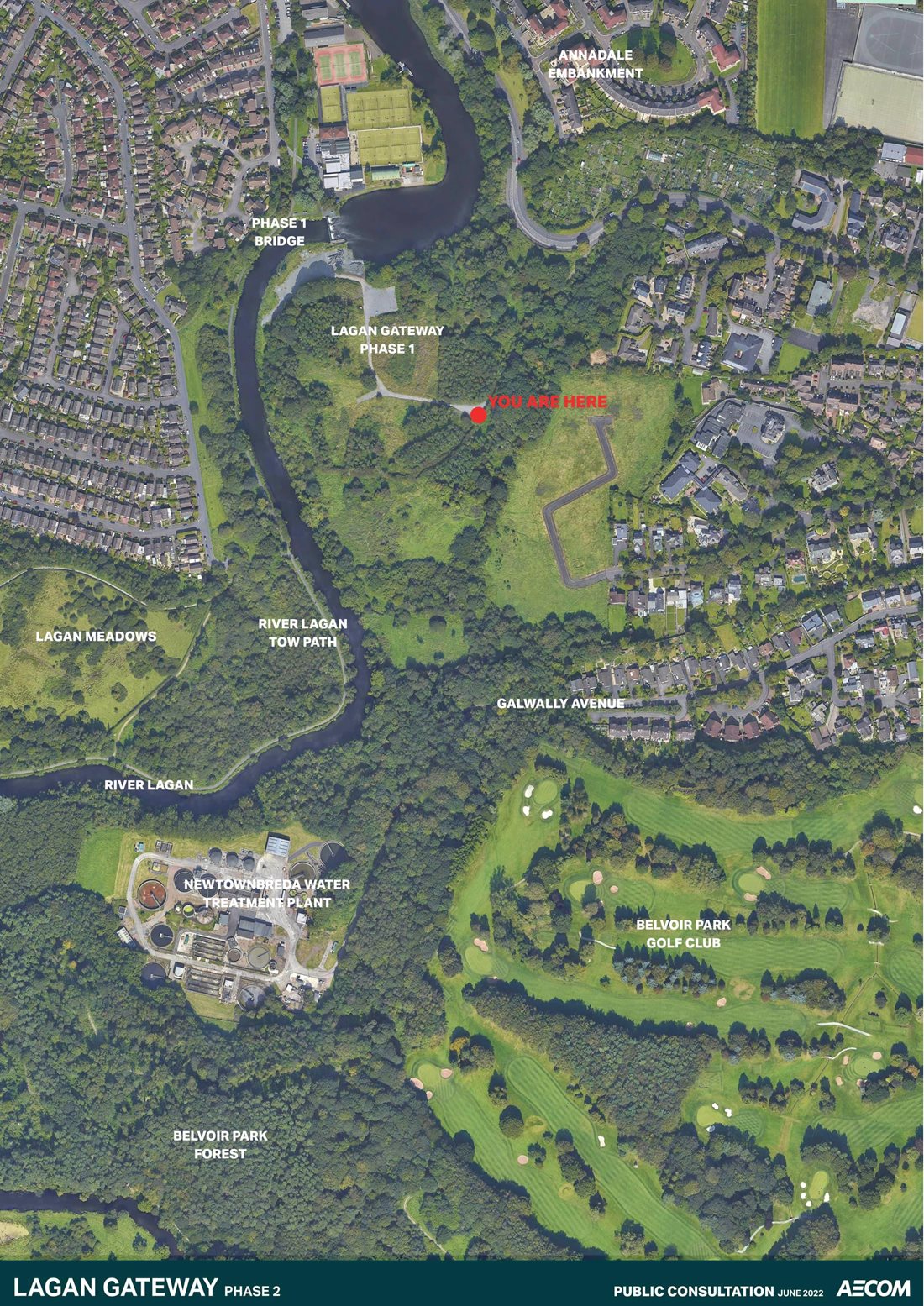
Aerial photo showing the area of Phase 1 and Phase 2 of Lagan Gateway project between Stranmillis, Annadale Embankment and Belvoir Forest Park.
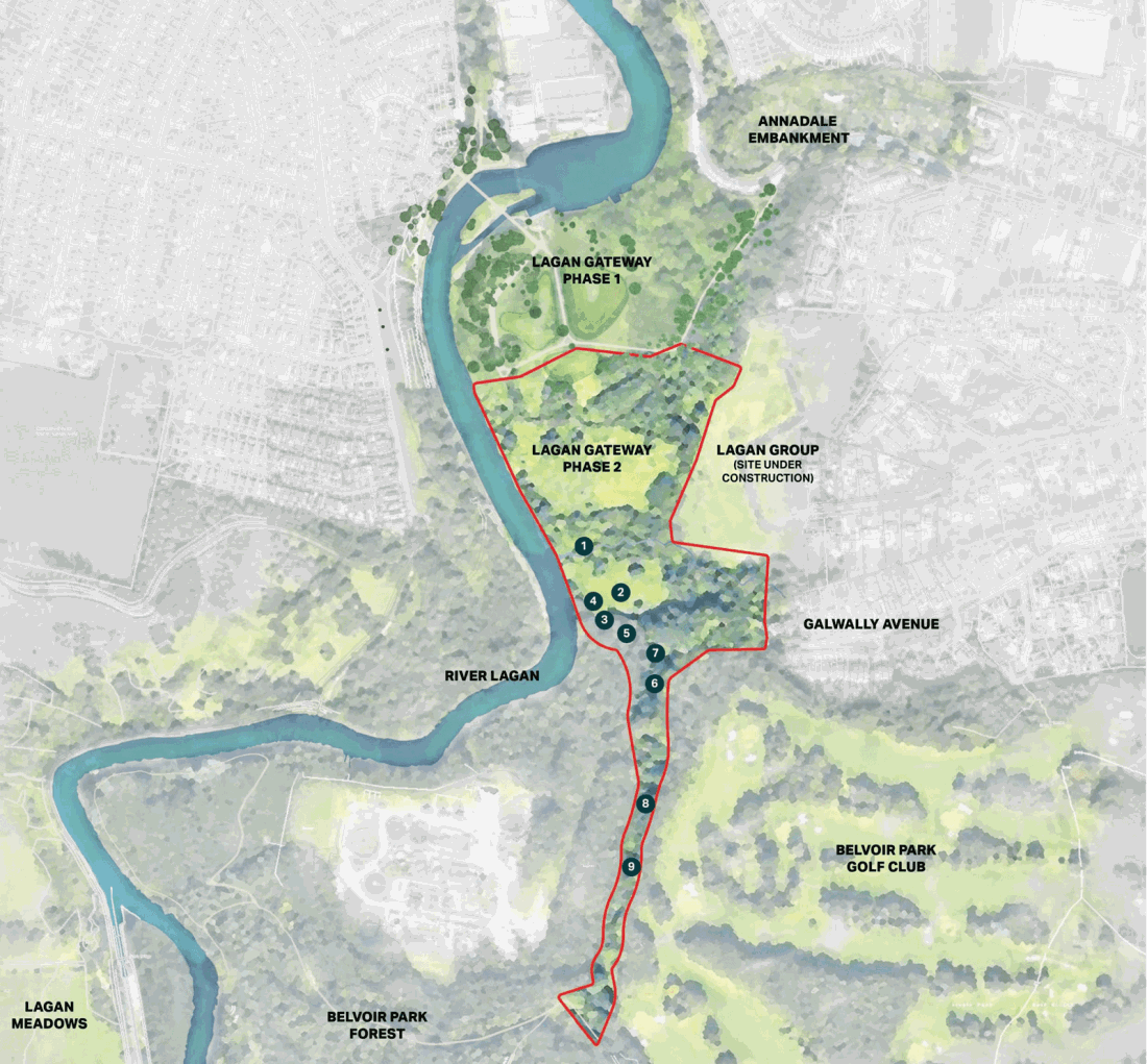
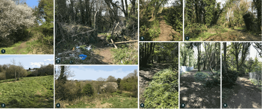
Map showing Stranmillis area of south Belfast with a red boundary line showing the proposed area where Lagan Gateway phase 2 works will take place. The main landmarks highlighted on the map include Annadale Embankment to the north, existing housing to the east and west (including the location of Lagan Group’s proposed housing development) and Belvoir Park Golf Club to the south east. The map has a key which is numbered one to nine to illustrate: 1 is an existing trail at the northern part of the site, 2 and 4 are open meadows in central part of the site, 3 and 5 are existing trails in central part of the site, 6, 7, 8 and 9 are existing trails through Belvoir Forest Park adjacent to the golf club
What would you like to see?
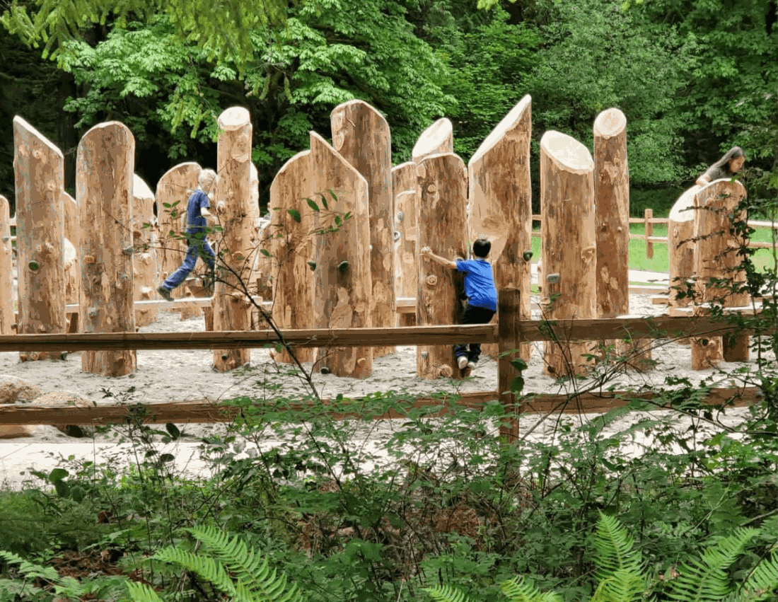
- Informal natural play
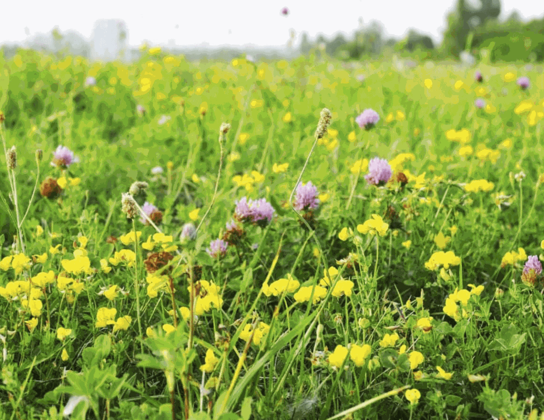
- Native wildflower/grass meadows
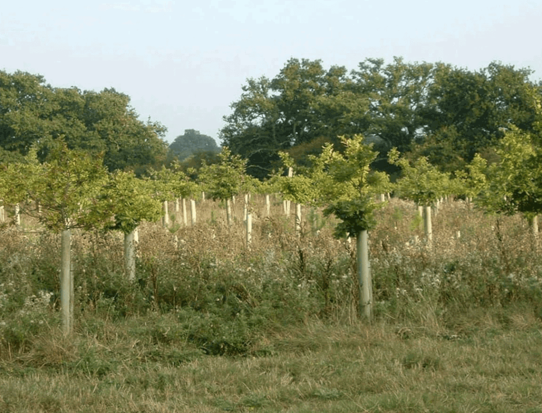
- New native woodland planting
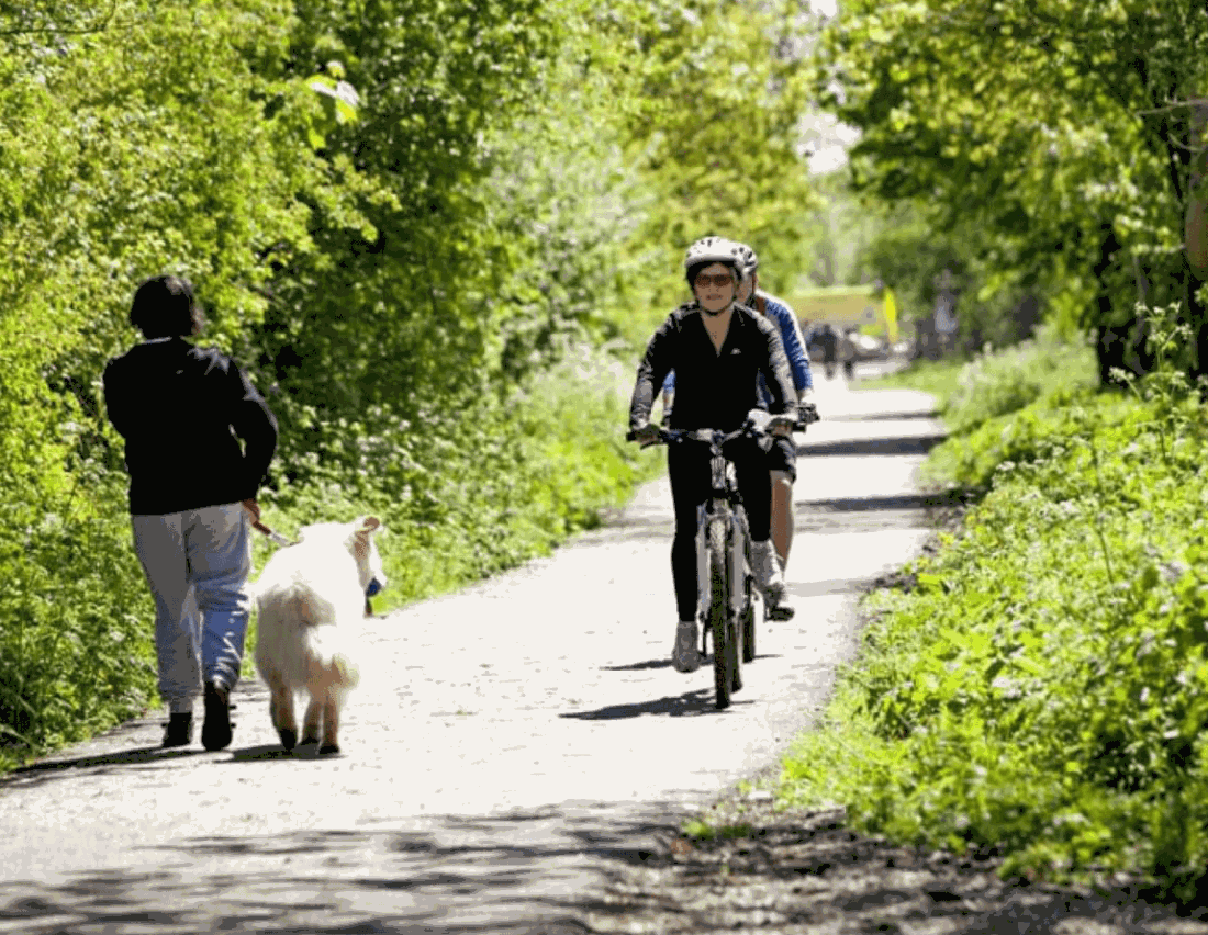
- Shared pedestrian and cycle paths
- Feature elevated boardwalk
- Informal compacted gravel paths