It looks like you're using IE11...
This browser offers limited functionality on our website. We recommend you use the latest version of Chrome, Safari, Edge and Firefox.
Horizon Europe has funded us to become an UP2030 pilot city (link opens in new window)
During this three-year programme, we’ll work in partnership with other global cities including Lisbon, Milan and Rotterdam to develop a framework for creating Net Zero neighbourhoods, with the aim of being able to scale and deliver this in any city in the future.
Belfast’s Resilience Strategy, our Net Zero Carbon Roadmap and the One Million Trees programme are the foundations for our ambitions to achieve carbon neutrality (80 per cent reduction by 2030 and 100 per cent by 2050). We’ve also prioritised making our city centre more liveable, sustainable, connected and mixed-use in the multi-partner strategy, A Bolder Vision for Belfast. We want to create a people-focused environment with playful streets and spaces for children and families to live and thrive.
UP2030 will guide us through the changes we need to make to become climate neutral and we’ll use urban planning and design to create neighbourhoods which offer better quality of life.
UP2030 is putting cities at the centre of the innovation that’s needed to drive transformative change by helping them to:
We’re looking forward to working with a wide range of partners and representatives from the pilot area (the Market, Donegall Pass, Sandy Row, Barracks Street and the Linen Quarter district, which aims to become NI’s first sustainable and net zero business district) to create a framework to guide all future regeneration projects - integrating tree planting, green infrastructure, play and co-design with young people.
We’ll be engaging with residents, and representatives from transport to industry, seeking opportunities to align with relevant plans and projects and co-designing the actions we take. The framework that we design together will provide a menu of options for integrating Net Zero into neighbourhoods. And we’ll use the lessons we learn during this pilot to identify opportunities for rolling out the concept of Net Zero districts across the city.
Map of the pilot area:
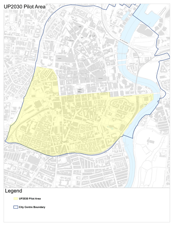
The boundary for UP2030 extends westward from East Bridge Street, proceeding north onto Cromac Street and west along May Street, Donegall Square South, Howard Street, and onto Grosvenor Road at its junction with Westlink. It extends southwards to encompass Great Victoria Street, lower Donegall Road, Donegall Pass, lower Ormeau Road, and Gasworks and Market areas. From the Grosvenor and Westlink junction, the boundary extends North along Westlink as far as Divis Street, and eastwards to College Avenue.